
Part 17: Kelso to Speyside
Date: Wednesday 22 August 2018
Start: Kelso Conservation Area
End: Speyside Resource Management Area
Distance covered: 13 km
Total distance covered: 214.8 km

203. A damp start to the day as we set out from Kelso. There are already plenty of kids about waiting to start their various programs. The Trail is damp after an overnight downpour, though after this early drizzle the rest of the morning stays dry but very humid.

204. We are approaching another milestone in our odyssey. This bridge carries Highway 401 over Appleby Line. The 401, whose section through Toronto is Canada’s busiest and widest highway, runs from the US border at Windsor to the Quebec border near Montreal. Once under the 401 …

205. … we have crossed the boundary between the Iroquoia and Toronto Club Sections of the Bruce Trail. (We entered Iroquoia Club territory in Part 7.) The border between the Iroquoia and Toronto Clubs is at km 203.4, which means that we have now completed 22.7% of the Trail. The Toronto Section, the shortest of the nine, runs 49.9 km from Highway 401 to the Cheltenham Badlands.

206. We’re a bit disappointed, however, that the Toronto Club doesn’t provide a sign welcoming us to their Section. Instead there is this plaque affixed to a rock: “Near this spot the first blaze on the Bruce Trail was painted in July 1962. Erected by the Toronto Bruce Trail Club to commemorate forty years of cooperation between the landowners and volunteers of the Bruce Trail.”

207. Looking back south, we see the Escarpment at Kelso standing ruggedly in the morning sun. As the poet for whom the town of Milton was named might have described the scene:
“Insuperable height of loftiest shade,
Cedar, and pine, and fir, and branching palm,
A sylvan scene, and, as the ranks ascend,
Shade above shade, a woody theatre
Of stateliest view….”

208. … but the prospect to the east is a different story. Milton described a similar scene in Paradise Lost:
“The dismal situation waste and wild.
A dungeon horrible, on all sides round,
As one great furnace flamed; yet from those flames
No light; but rather darkness visible
Served only to discover sights of woe ….”
Worse is to come. Deep in the woods near the top of the Escarpment, we hear a noise that first we assume is a passing train (though there are no nearby tracks), then a Niagara-sized waterfall (none is marked on the map), until suddenly we find ourselves on the brink of a manmade chasm …

209. … and are shocked to discover that a whole section of the Escarpment has gone missing! A road (unmarked on the Bruce Trail app) has been driven through the gap …

210. … and once again Paradise Lost comes to mind:
“… a broad and beaten way
Over the dark Abyss, whose boiling gulf
Tamely endured a bridge of wondrous length,
From Hell continued, reaching th’ utmost orb
Of this frail World …”
The roaring noise, which never ceases …

211. … is made by conveyor belts pouring aggregate into a pile and from there into the buckets of an endless crocodile of dump trucks. Yes, Milton the poet would have instantly recognised the “abortive gulf” known locally as the Dufferin Gap!
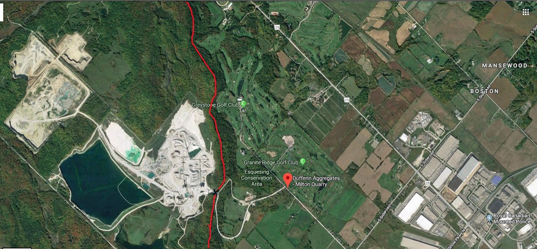
211.1. A satellite view, courtesy of Google Maps, shows the scale of the Dufferin Aggregates Milton operation. The red line is an approximately 5 km section of the Bruce Trail, following the treed course of the Escarpment. The quarry includes the white patches to the left of the line. The Dufferin Gap, at the black cross, was blasted through the Escarpment in 1962 so trucks would have easier access to the quarry. It was this outrage that indirectly led to the creation of the Niagara Escarpment Commission in 1973. Since then little has changed for the better, unless you count the installation of the pedestrian bridge and a side trail shamelessly touting a viewpoint over the quarry. Can anything good be said to have come out of this environmental atrocity? Hopefully, public awareness of what the quarry industry, if allowed to regulate itself, is capable of: smashing to fragments the Niagara Escarpment, that “strictly protected” UNESCO World Biosphere Reserve, and trucking it away, bit by bit.

212. Let’s put Milton behind us and return to the forest. These bright red wayside blooms are cardinal flowers (Lobelia cardinalis), which enjoy marshy spots and are favourites of hummingbirds. Their name alludes to the scarlet robes of Catholic cardinals.

213. Nature paints an abstract expressionist masterpiece on a lichen- and moss-covered rock.

214. They may look a bit like blueberries but actually they are the fruit of the blue cohosh (Caulophyllum thalictroides), clustered at the end of stalks near the forest floor. The berries are not considered edible but have been used in traditional obstetric medicine.

215. Towards the end of today’s hike, we notice this poster stapled to a Trailside tree. According to a map on the SOB website, Ontario is practically swarming with Bigfeet, Sasquatches, and their ilk. All over the province there have been sightings, footprints, tree knockings, nesting sites, rock-throwing incidents, vocalizations, and incidences of “bad odour” emanating from elusive big hairy apemen. Yet our encounters on the Trail with bipedal hominids of any description, even regular-sized ones with smooth skins and backpacks, have been scarce.
Go to Part 18: Speyside to Sixth Line
