
Map 5. Governors Road, Dundas, from Main Street to St. Bernadette School. Governors Road, the local name for Dundas Street, runs west-south-west, bypassing Dundas’s business district on King Street.
From its earliest days, Dundas was the hub of trails that prefigure today’s road system: Governors Road west to Paris, Woodstock, and London; King Street northwest to Galt or north via Brock Road to Guelph; York Street / York Road northeast to Toronto; Main Street / Osler Drive east to Hamilton and Niagara; Ogilvie Street / Old Ancaster Road southwest to Ancaster and Brantford. Now, however, the main roads in the area – Highways 5, 6, and 403 – bypass central Dundas entirely. The Valley Town is a quiet backwater these days … which is how most of its residents like it.
What Dundas does not like is to be referred to as a suburb of Hamilton, even though this has been technically the case since Dundas’s extremely unwilling absorption by the City of Hamilton on 1 January 2001. The animosity between Dundas and Hamilton that resurfaced then is now more than two centuries old. It may have begun when Dundas, the older settlement, was passed over as the County Town of Gore District in 1816 in favour of the upstart Hamilton.
Hamiltonians subsequently registered their disapproval of Dundas’s preference for Responsible Government over the Family Compact. The Hamilton Spectator in 1849 called Dundas “the most purely violent and radical place of its size in Western Canada … the somewhat notorious Wm. Lyon Mackenzie here began his career; succeeding we believe the other reptiles for which the place was noted and which procured for it the designation of Ratttlesnake Den”* (quoted in Byers 10). “Place of its size” was a dig at the increasing disparity between the two settlements. And indeed the population of Hamilton today is at least twenty times that of Dundas, so to continue to see them as conventional interurban rivals is absurd.
But though Dundas may have been soundly beaten in its attempt to command the head of Lake Ontario, in other, subtler ways, it has quietly come out on top. It’s an attractive, liveable small town in a spectacular location with a distinctive history and an independent spirit … and if you want to live there, be prepared to pay about twice what you’d pay for a similar property in its much larger neighbour.
*As Elizabeth Simcoe’s diary reminds us, real rattlesnakes once abounded on the face of the Niagara Escarpment which encloses the Valley Town (see #9 above).

45. The first white settlers in the Dundas area were the widow Anne Morden (1743-1832) and her four sons, three daughters, one nephew, and two orphaned granddaughters. They were Quaker refugees from Pennsylvania, where Anne’s husband had been executed as a British spy. In 1787 the Mordens built a squatter’s cabin just off the top right corner of Map 5 above. Simcoe’s Queen’s Rangers laid out Dundas Street in 1793, the same year that the Mordens were granted Loyalist land rights. In 1799 the Mordens built a sawmill between Dundas Street and Spencer Creek,* then sold the property to Edward Peer in 1801. That year Peer built a grist mill, which he named “Dundas Mill” for the street it was on, near where Governors Road and Main Street now intersect.
Richard Hatt and his brother Samuel, immigrants from London, England, bought this mill and its surrounding land from 1804-08. With the help of the Pennsylvania millwright Manuel Overfield, the Hatts greatly expanded the industrial settlement, now known as “New Dundas Mills.” By 1814 the community around the Mills was large enough to require an official post office, located in the Hatts’ general store (see #47 below). The address of this post office, the first in Upper Canada west of York, was simply “Dundas.” That’s when this name superseded “Cootes Paradise,” the townplot east of here incompetently surveyed in 1801.
By the time of his death in 1819, Richard Hatt owned all the water privileges on Spencer Creek, three farms, two saw mills, a grist mill, a store, a cooper’s shop, a blacksmith shop, a distillery, and several houses. Hatt’s mill wheels were driven not by Spencer Creek itself but by a mill race running parallel to and north of the Creek. His main mill (above) was a limestone building four storeys high. From 1835 it was owned by James Bell Ewart; in 1900 it became the Kerr Milling Company; and later it was used as a storehouse by Top Notch Feeds. All but one of the mill buildings were demolished in 1968. The site at 15 Governors Road is currently occupied by Dundas’s only supermarket and its parking lot.
*This stream was known first as Morden’s Creek, then Dundas Creek. It’s been called Spencer Creek since about 1834.

46. Dundas had petitioned for incorporation as a town from the time of the opening of the Desjardins Canal in 1837. But requests had been ignored by the government of Upper Canada, probably because of Dundas’s radical reputation through its connection with William Lyon Mackenzie. Meanwhile, neighbouring rival Hamilton, though it was barely 30 years old, had been granted city status in 1846. Eventually, a decade after Mackenzie’s abortive rebellion, Dundas was incorporated on 28 July 1847. A town hall was required.
Benjamin and Samuel Overfield, sons of Manuel, donated a triangle of land called Hay Scale Square where Main and Hatt Streets meet. So Dundas Town Hall does not stand on Governors Road, but 50 metres to the north. Its construction was put out to tender, and a bid of £1,870 by builder James Scott was accepted. It was designed by local millowner Francis Hawkins; Scottish stonemason William Fisher helped build its walls of Whirlpool sandstone. The building embodies a classically-inspired solidity and civic dignity.
The Town Hall’s council chamber was first occupied on 16 July 1849; Dundas’s population in that year was 2,311. Town offices were on the main floor, and upstairs was a large chamber that served as a ballroom and as a venue for political meetings, plays, and operas. The basement contained butchers’ stalls, farmers’ stands, a saloon, and a jail: “very handy for the policeman – he had to drag drunks only a few feet” (Woodhouse 220-28). It’s one of the oldest and finest pre-Confederation municipal buildings in Ontario, and was the first edifice in Dundas to receive a heritage designation. But after Dundas was absorbed by the City of Hamilton, the building lost its primary function. It’s now a ServiceOntario facility, where you go for drivers’ licences and health cards. Its pink cupola remains visible from many of the high viewpoints over the Dundas Valley.
In the 2001 amalgamation, Hamilton absorbed several other affluent peripheral municipalities. What Hamilton gained was a boost to its faltering tax base. It’s much less clear what Dundas, Ancaster, Waterdown, Flamborough, and Stoney Creek got out of the arrangement. In Dundas’s case, a single seat on 15-member Hamilton City Council was hardly a suitable recompense for the total loss of municipal independence.


47. (Top) Only one building remains from Hatt’s New Dundas Mills complex: his former general store-cum-post office, built from Escarpment dolostone probably in 1804. Though its southern side adjoins Governors Road, its address is 2 Hatt Street. It’s the oldest building in town, and may be the oldest still standing along the entire length of the original Dundas Street.
(Middle) You’d think that such an old building in such a historic location would be cherished, but you’d be wrong. After spending a number of years as a blacksmith shop, a private residence, and a retail lighting outlet, it’s been empty since 2013 and its entrance is now boarded up. Presumably the Quebec-based owners were hoping that demolition by neglect would save them the expense of maintenance. However, after about 20 years of recommendations and proposals – so dilatory is the Hamilton Municipal Heritage Committee – the building did receive Ontario Heritage Designation in August 2025.
(Bottom) In the meantime, its crudely patched-up walls offer shelter for a variety of critters. Yet rumours of its imminent collapse have so far proved unfounded. It’s a survivor, this little building, and one hopes it’ll receive some urgent TLC and a new purpose in its old age.

48. Less than one block after Main Street, Governors Road crosses Spencer Creek. The town of Dundas owes its existence to this waterway, distinguished chiefly by the fact that it drops 187 metres (615 feet) from its source atop the Niagara Escarpment to its mouth at Cootes Paradise. While lesser creeks freeze over, thanks to this drop Spencer Creek continues to flow even in winter, as we have seen. With the help of a dam and a mill race (both now gone), it consistently provided hundreds of horsepower to the waterwheels of mills built by its side.


49. (Top) A plaque bearing the title “Dundas Mills” stands in a field across Governors Road from the former site of #45 above. It reads: “By 1799, the Morden family had a sawmill near this site on Spencer Creek north of Dundas Street. They sold this property in 1800 to Edward Peer, who built a grist-mill about 300 yards southeast, close to Dundas Street, and adopted the name Dundas Mills. Peer sold the property in 1804 to Richard and Samuel Hatt and a partner, but by 1807 Richard had become sole owner. Then, or slightly earlier, Richard Hatt built northwest of Peer’s grist-mill the tall stone flour mill that stood near this site until 1968. The other mills were destroyed long before. The community of ‘Dundas Mills’ became part of the town of Dundas in 1847.” On a rise in the background at left are the St. Joseph’s Estates condos.
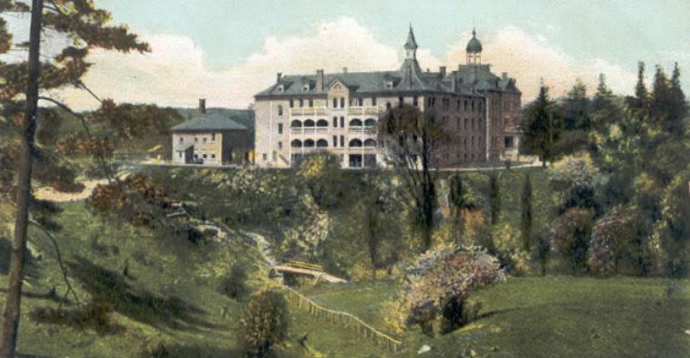
(Bottom) On that rise once stood Coleman’s Castle, a huge residence built by the merchant James Coleman, wealthy thanks to the Desjardins Canal. It twice burned down, so Coleman, believing the building to be cursed, sold it to the Methodist church for their Wesleyan Institute, a boarding school for boys. That lasted only from 1874-78, when it was closed down because of the boys’ unruly behaviour. In 1879 the building, later greatly expanded, became the Catholic-run House of Providence, a home for the elderly, orphaned, and disadvantaged, the forerunner of today’s St. Joseph’s Villa (see #53 below). The enormous edifice was demolished in 1971 after the current St. Joseph’s Villa was built.

50. On the Governor’s Estate highrise apartment building (built 1974) at 50 Governors Road is this giant mural. No one seems to know who painted it. It’s probably a depiction of the Titan Prometheus, who stole fire (the source of human technology) from heaven (the sun) and gave it to humanity, to our great benefit but incurring the jealous wrath of the Olympian gods. To punish the immortal Prometheus, Zeus bound him to a rock and dispatched an eagle to tear out and eat his liver every time it regrew.
Quite why this image from Greek mythology dominates this stretch of Governors Road in both directions is unclear. However, the Dundas cartoonist Graeme MacKay has licensed the image and made it available on various merchandise through Redbubble. If you want instant recognition by fellow aficionados of the Valley Town, then sport a T-shirt depicting the Dundas Prometheus.


51. (Top) Dundas was once an industrial powerhouse. The enormous factory complex of John Bertram and Sons, a.k.a. The Canada Tool Works, occupied the site between Hatt Street (along which the streetcar is running), Ogilvie Street (meeting Hatt at right angles from the left), and Spencer Creek. A section of Governors Road is visible in the upper left background.
At its peak the Bertram enterprise made wood- and metal-working machine tools: planers, shapers, drills, milling machines, lathes, bolt cutters, punchers, shears, slotting machines, plate bending rolls, steam hammers, and radial drills. After 1905, its Pratt and Whitney Division made smaller tools and gauges. In WWI the main shop was refitted to manufacture artillery shells, while in WWII Bertram machine tools were widely used to manufacture marine engines, tanks, gun mounts and ships. Postwar, the factory passed through a variety of different owners, the last being Orenstein and Koppel, until changing economic circumstances led to its closure and the demolition of most of it.
However, three buildings in the foreground still stand. The two larger ones have been converted to loft condos and a rest home, while the middle one is now the Dundas Valley School of Art.
(Middle) The upscale Amica Retirement Home, and (bottom) Spencer Creek Village midrise apartments sit where the large factory complex in back once stood.

52. Governors Road looking east from its junction with Ogilvie Street. New Dundas Mills stood where that Metro supermarket sign now stands.
Simcoe’s Dundas Street was the dividing line between York and Lincoln Counties, and subsequently between West Flamborough and Ancaster Townships. In the early days, when serving on juries, Dundas residents on the north side of the Governors Road (left above) had to go to York, those on the south side to Niagara.

53. St. Joseph’s Villa (1970) at 56 Governor’s Road is one of Ontario’s largest long-term care homes, with 425 residents. Sharing the same “campus” are St. Joseph’s Estates condos, providing independent living for those 55+, and St. Margaret’s Place, a hospice. You might say that this huge facility and several other similar institutions for the elderly and infirm now constitute Dundas’s main industry.
Three historic villas built in the mid-19th century on high ground overlooking the south side of Governors Road form ”an historic complex that is of provincial significance” (Cuming 24) Their ownership also reveals something of Dundas life at the time of its incorporation.

54. Orchard Hill, 190 Governors Road, built ca. 1848 on land owned by the Overfield family. Though it has a Governors Road address, the house faces Overfield Street, from where it is best viewed.
Orchard Hill is a brick house built in Flemish bond. The front portico is an addition from the 1920s. It was first occupied by Rev. William McMurray (1810-94), an Irish-born Anglican missionary to the Natives of the Upper Great Lakes. He was married to Charlotte, the daughter of John Johnston, fur trader of Sault Ste. Marie and his wife Susan (Ozhahguscodaywayquay), herself the daughter of an Ojibwa Chief. Charlotte was fluent in French, English, and Ojibwa, and served as her husband’s interpreter on his tours in the north. The McMurrays came to Dundas in 1838 to serve the Anglican parishes of St. James and St. John’s, Ancaster. From then till 1857, Rev. McMurray was an important local religious leader.
Orchard Hill was later owned by Alexander Richard Wardell, lawyer and Mayor of Dundas from 1868-1871 and 1879. In 1920 Fred Warren, architect and MPP, bought it and returned it to its original grandeur.
“190 Governor’s Road is a gracious, two-storey, brick Georgian mansion that is attractively situated on a small rise of land. Both the centre-hall plan and symmetrical window placement are characteristic of the Georgian style. Of particular architectural interest are the vernacular, Palladian window above the entrance, the horizontal proportions of the facade, and the relatively low central gable indicative of its early date. The interior continues the same gracious proportions and high quality of craftsmanship that the exterior displays” Ontario Heritage Trust.

55. Foxbar, 10 Overfield Street, built 1845.
Foxbar was built by Scottish stonemasons for Alexander Robertson, born in Foxbar, Scotland, and his wife Matilda Simons. It was passed on to their son Thomas, a lawyer, till 1878, when Thomas was elected Liberal MP and moved to Hamilton. The house then was occupied by the Binkley family and later by Frank Ernest Lennard, partner in the Dundas hosiery and knitted underwear firm. In 1931 a fire destroyed the interior. In 1936 it passed to Lennard’s son Frank Exton Lennard, later a Conservative MP. Subsequently it became a home for severely handicapped children. There are pictures of the interior in Shaw 51-3 and at ontarioarchitecture.com
The house is currently in private hands. It served as the exterior set for Grey House in the Hallmark Channel’s The Good Witch franchise, which includes seven made-for-TV films (2008-14) and a subsequent seven-season TV series (2015-21). Foxbar’s owner has described visits by passionate fans of the series: “They just want to see Grey House … They’ve come from California, Chicago, Texas, Florida, Australia and a couple came from Italy … It’s just craziness … A couple of them have cried. ‘She walked on this floor.’ They get quite emotional.”

56. Ballindalloch, 192 Governors Road, built ca. 1865.
This striking house is on the south side of Governors Road just west of its intersection with Overfield Street. Quite unlike any other house in the area, it’s been described as a Tuscan villa as conceived by Italianate Revival architects active in upstate New York (Norris 54). It was built for John Forsyth, a former Gartshore Foundry apprentice who went on to found factories in Dundas making screws, farm machinery, sewing machines, and stoves. Forsyth had a family connection to Ballindalloch, a village on the River Spey in Scotland known for its castle and whisky distilleries. The house was later owned by James Somerville (1834-1916), owner of the Dundas True Banner newspaper, Mayor of Dundas (1874), and long-serving Liberal MP (1882-1900). A Reformer in the Dundas tradition, Somerville strongly opposed the policies of Tory Prime Minister John A. Macdonald.

57. Q. What’s unusual about this picture taken at the corner of Governors Road and Avon Drive? (Hint: it’s nothing to do with Dundas Baptist Church at 201 Governors Road.)
A. The apostrophe on the green street sign! The singular possessive form of Governor, long forgotten just about everywhere else, is technically accurate: Dundas Street was Simcoe’s pet project.

58. Looking west, Governors Road runs steeply down another of the Valley’s glacial mounds and past its junction with Creighton Road. The segregated bike path on the south side of this heavily trafficked section of the Road is a recent development. It improves the safety of the many schoolchildren who use it on their way to and from Dundas’s main school district at the top of the far rise.

59. On the south side of Governors Road at Huntingwood Avenue, a new townhouse development is being built. Only five years ago, this small lot, surrounded on all sides by suburbia, contained an overgrown orchard around an abandoned barn, where this deer and I surprised one another.

Map 6. From Dundas Valley Secondary School to Binkley Road.
This map takes us from the western edge of Dundas, through the Dundas Valley Conservation Area, over the Niagara Escarpment, as far as the former limit of the town of Dundas just east of Binkley Road. All this area is now part of the City of Hamilton.

60. Dundas Street earns a Government of Canada plaque on a cairn in front of Dundas Valley Secondary School (DVSS) at 310 Governors Road. The plaque reads: “Dundas Street, named for Henry Dundas, Secretary of State for the British Home Department (1791-1794), was built on Lieutenant Governor Simcoe’s orders in 1793-1794. The road, cut by a party of Queen’s Rangers from Burlington Bay to the upper forks, a navigable point on the Thames River, was part of a land and water communications system linking Detroit and Montreal. The road also connected the site of Simcoe’s proposed capital, London, 26 km downstream, with the larger network. While Simcoe’s primary consideration was military, Dundas Street also helped to open the region for settlement.”
The placement of the cairn on this site – rather than, say, at the east end of Dundas Street (see Part 1) – was perhaps intended to enlighten the many kids who pass by it daily: DVSS high schoolers and their younger counterparts at St. Bernadette and Sir William Osler Elementary Schools. But the plaque fails to anticipate the response of almost anyone who reads it: “Dundas Street? But this is Governors Road!”


61. This section of Governors Road cuts through an extensive tract of suburbia.
(Top) The Road, bisecting the Dundas Valley, crosses another couple of glacial hummocks …
(Bottom) … before flattening out as it approaches the edge of the built-up area.

62. The Dundas Water Tower, a landmark rising from the thickly forested Dundas Valley, stands 200 m south of Governors Road behind Sir William Osler Elementary School. The steep face of the Escarpment looms in the background.

63. We’ve reached the western limit of Hamilton’s public – and not very rapid – transit system. From here at Governors Road and Pirie Drive, the 5B Delaware bus runs roughly every 30 minutes to Hamilton’s east end, taking well over an hour to make the trip of almost 20 km.


64. (Top) The bus stop above is 400 m short of the main entrance to Dundas Valley Conservation Area (DVCA) at 650 Governors Road. So if you want to walk in to the DVCA from there, you’ll have to negotiate the Governors Road shoulder. Shorten the unpleasantness by turning left on quiet Ridgewood Boulevard, from where you can access the John White Trail.
(Bottom) The DVCA is the Hamilton Conservation Authority’s crown jewel, and the HCA would prefer you to arrive by car, as the admission fee is $11.50 per vehicle while pedestrians walk in free.
Conservation authorities were set up to safeguard the natural environment from water pollution and protect human infrastructure from flooding. But years of reductions in provincial funding, increased political interference, and lobbying by developers, have severely limited their capacity to fulfil their original mandate. Their current policy seems to be to monetize every asset at the expense of affordable accessibility by the general public.
The Ontario government currently plans to merge 36 Conservation Authorities into nine umbrella regions. Critics argue, not without cause, that this will take away the ability of conservation officers to maintain consistent scrutiny over their local watersheds, while making conservation lands more vulnerable to inappropriate development.

65. The DVCA has two faces. North of Governors Road is rolling open countryside, offering spectacular views from high hummocks eastward over the Dundas Valley as far as Lake Ontario. This area is where to go to enjoy fall colours.

66. South of Governors Road, there’s a large parking lot at the end of the access road (#64 above). From it, trails thread heavily wooded ravines in the heart of the Valley, where Spring and Sulphur Creeks wind their way eastward towards their rendezvous with Spencer Creek. This lovely forest is where to get back in touch with nature, though in winter the absence of leafage discloses that you are rarely far from suburban backyards.

67. The Trail Centre, 200 m from the parking lot, is a simulation of a 19th-century train station. Here the 900 km Bruce Trail, Canada’s oldest and longest waymarked hiking trail, crosses the bike-friendly 35 km Hamilton to Brantford Rail Trail. It’s one of the most important and popular trail hubs in southern Ontario.
The Dundas Valley Conservation Area is a wonderful resource, so it’s more than a little alarming to learn how close we came to losing it. In 1967 the Government of Ontario planned to build a four-lane highway, about 11 km long, diagonally between Peters Corners at the junction of Highways 5 and 8, and what was then the proposed junction of Highway 403 and Mohawk Road in Ancaster.
On a map, this road, the Dundas Bypass as it was called, seemed to make sense. But on the ground it would have been a disaster. The Bypass would have scythed through the site of the Trail Centre above and what is now the Main Loop Trail of the DVCA, and the heart of the Dundas Valley would have been buried under concrete and asphalt. The story is told by Thomas A. Beckett in his memoir My Path to the Dundas Valley (127-33). He recalls that only a direct appeal to John Robarts, Ontario Premier at the time, killed the plan.
Beckett concludes: “maybe it is time to recognize John Robarts, not just for killing the highway but for all he did in creating and sustaining a conservation authority movement in Ontario. One of his successors, Mike Harris, did whatever he could to destroy the Conservation Authorities by reducing their subsidies from 50% or more to near zero, but thankfully most have survived, although with a much-reduced means to carry out their collective mandates” (133). Can the present Ontario Government, with its mantra of “getting shovels in the ground” and its plans to amalgamate the Conservation Authorities, be trusted to safeguard the precious legacy embodied by the DVCA?

68. Back to Governors Road. A magnificent barn on the north side belongs to Valley Farm, a facility for boarding horses. If you take, first, the section of the Bruce Trail running north from Governors Road (#69 below), then the McCormick Trail loop to the west, chances are you’ll have a close encounter with some of the beautiful animals grazing in neighbouring fields.

69. Here’s where the Bruce Trail, its white “Keep Straight On” blaze visible at the top of the rise, meets Governors Road. The Bruce here briefly shares its route with the McCormick Trail of the DVCA. If you fancy starting a hike here, there’s plenty of space to park on the shoulder of Governors Road, but you’ll be ticketed if you do, even if you’ve laid out $130 + HST to display your HCA annual pass. The neurotic display of warning signs above suggests that HCA bureaucrats have too much time on their hands and are too little concerned to provide affordable public access to their lands. They’ve even placed a collection box under that blue sign to guilt long-distance Bruce Trail hikers into donating their toonies! By acting in this penny-pinching way, Conservation Authorities, hamstrung by government cuts, are losing public trust and unfortunately playing into the hands of those who wish to reduce their power even further.


70. (Top) There don’t seem to be any contemporary visual depictions of Simcoe’s original Dundas Street. But an old photograph of Governors Road gives some sense of what it looked like back in the day.
Guillet’s The Story of Canadian Roads explains what early road construction in Upper Canada involved: “an explorer went ahead to mark out its rough course; he was closely followed by two surveyors with compasses. Blazers then notched trees on either side to show the boundaries, and axemen chopped down those which lay in the roadway. Gangs of men followed with oxen to clear away the trunks and brush, and wagons with provisions brought up the rear … Usually the larger stumps were left in the ground to rot, often for years, and consequently few routes ran straight over even short sections. There were no mechanical aids. Ploughs were sometimes used instead of shovels to level hills, but in general hand tools predominated. It was hard, exhausting work. Fever and ague frequently struck, decimating the work crews, and deaths were not uncommon” (49).
The roadway would be quickly reclaimed by nature unless there were settlers along it who, in return for their land grants, had promised to keep their section cleared. And travel, by wagon or sleigh, was always easier in winter, when the frozen earth offered a hard surface rather than the knee-deep mud of the milder seasons.
(Bottom) I like to think that this is the stretch of Governors Road depicted in the old photo above. It’s looking west just after the intersection with the Bruce Trail (#69 above).


71. (Top) The Niagara Escarpment, like a letter U lying on its right side, makes a tight turn around the western end of Lake Ontario. The arms of the U, about 4 km apart, enclose the town of Dundas and its Valley. While those arms turn a precipitous face to the Valley, the midpoint of the curve that connects them is much less steep, thanks to accumulated glacial rubble. The Queen’s Rangers who opened Simcoe’s Dundas Street undoubtedly followed the course of an existing Native trail that allowed a relatively easy portage over that point. If you turn left at this junction …
(Bottom) … you find yourself on Sulphur Springs Road, a winding gravel road that takes you into the heart of the Valley. Soon you cross the Hamilton to Brantford Rail Trail, along the line of former Toronto, Hamilton and Buffalo (TH&B) Railway, abandoned in 1986. This brilliantly engineered line, rising almost imperceptibly from east to west, allowed trains from Hamilton to Brantford to mount the Escarpment with ease. And today the section of the Rail Trail from west Hamilton to Highway 52 is a fine way to enjoy the beauty of the Dundas Valley by bike or on foot.
The small sign on the tall post above indicates that this was “Brock’s Route, 1812.” In August 1812, the USA having declared war the previous month, Major-General Sir Isaac Brock, commander of British forces in Upper Canada, made his famous journey from York to Detroit. Of course, there was no railway or rail trail in those days. But there was Dundas Street, Simcoe’s military road, just north of here. So which way did Brock and his men go?
Brock’s 1845 biographer believed he knew: Brock “left York on the 6th of August for Burlington Bay, whence he proceeded by land for Long Point, on Lake Erie. In passing the Mohawks’ village, on the Grand River, or Ouse, he desired the Indians there to tell him who were, and who were not, his friends; and at a council held on the 7th of August, they promised that about 60 of their number should follow him on the ensuing Monday, the 10th. At Long Point, a few regulars and nearly 300 militia embarked with him on the 8th of the same month in boats of every description, collected among the neighbouring farmers, who usually employed them for transporting their corn and flour” (Tupper 63).
Most subsequent accounts claim that it was at Port Dover, not Long Point, where Brock and his men boarded a flotilla of a dozen batteaux to sail to Fort Amherstberg (now Fort Malden). But most agree with Tupper that Brock did go via Brant’s Ford, then south to Lake Erie. It was at Detroit, of course, where Brock and his ally, Shawnee Chief Tecumseh, became Canadian legends by engineering the almost bloodless surrender of an American force almost twice the size of their own.
What all this tells us is that Brock and his men likely took a Native trail overland to Brant’s Ford, on a route that closely matched this section of today’s Hamilton to Brantford Rail Trail. Dundas Street may have been in no fit condition to handle marching men, and anyway didn’t lead far enough in the right direction. The time had come to put into practice Simcoe’s concept of an overland military route to Detroit, but sadly, Dundas Street failed to rise to the occasion.

72. Now Governors Road climbs the Escarpment, though most westbound drivers barely notice. It’s not much steeper than the rolling hillocks of the Dundas Valley that they’ve already negotiated.

73. Looking east from the junction of Governors Road with Binkley Road, 6.5 km from downtown Dundas. We’re now standing just outside the former limit of the former town. It’s 14 km from here to the centre of Hamilton, and there’s still a long way to go in the opposite direction before we reach the boundary between that city and Brant County.
Dundas started as a mill village, until steam engines made its water wheels redundant. It became a lake port, until the Burlington Canal and the railway era put paid to that ambition. It became a centre of manufacture, and then of heavy industry, but all that eventually migrated to Hamilton, then offshore. Now it’s a quiet dormitory town with only a few traces of its storied past. Governors Road, a.k.a. Dundas Street, is one of the most significant of those traces.
Part 3 coming soon
