
Before we start following Dundas Street’s easterly course to Toronto, let’s summarize where we’ve been so far:
- The first Lieutenant Governor of Upper Canada, John Graves Simcoe, had a vision: a military road between Montréal, then the largest settlement in British North America, and Detroit, a British fort guarding the entrance to the Upper Great Lakes. In the sparsely settled territory between those points, the road would allow inland travel and settlement that would be less vulnerable to US incursions by water.
- The section of Dundas Street between the head of Lake Ontario (now Dundas) and the site of what is now London was the first to be constructed, in two phases in 1793 and 1794. It connected the Lakehead to two navigable rivers, the Grand (flowing into Lake Erie) and the Thames (into Lake St. Clair). It was the only section completed before Simcoe left Upper Canada for good in July 1796.
- Simcoe named the road after Henry Dundas, then British Home Secretary. Dundas never visited Upper Canada, but he was knowledgeable about the province and, in their extensive correspondence, offered Simcoe good advice about its development. It was Dundas who persuaded Simcoe to choose York (now Toronto) as the provincial capital rather than Simcoe’s preferred site at the Forks of the Thames. York had a natural harbour defensible from US attack at a time when British military power was chiefly exercised through its navy.
- In recent years Henry Dundas has been maligned as one who deliberately obstructed anti-slavery legislation. Yet Dundas was without question an abolitionist. As a seasoned politician, however, he understood that a gradualist approach to abolition was more likely to prevail against powerful slaveholding interests in the British Houses of Parliament. In retrospect, his delaying strategy in 1792 was probably the correct one, as a bill to immediately abolish slavery would never have passed the House of Lords at that time.
- In early Upper Canada, the Native trail known as the Detroit Path was the preferred portage route west from the Lakehead, and Dundas Street remained in rudimentary condition. But gradually settlers with land grants requiring them to maintain their section of the roadway cleared the dense forest lining the Street. They uncovered, between Copetown and London, some of the best agricultural land in North America.
- Where Dundas Street crossed major rivers, settlements arose: Paris (1829) on the Grand; Woodstock (1800) at the navigable head of the Upper Thames; and London (1826) at the Forks of the Lower Thames. In each, “Dundas Street” is still today the name of the main east-west thoroughfare. In other places, “Governors Road” is used synonymously, commemorating Simcoe for his founding vision.
- Today, Highway 401, the Macdonald-Cartier Freeway, one of the busiest highways in North America, fulfils Simcoe’s vision of a great east-west inland route through southern Ontario. But low-key Dundas Street continues to exist in parallel to the 401. It should be celebrated as one of the few extant links to the earliest stage in Ontario’s settler history.

Map 16. Dundas Street toward Toronto begins at Clappison’s Corners* (see Map 19 below). This leaves a gap of roughly 8 km, with the Niagara Escarpment running through it, between it and the original Dundas Street. However, there was always a road through this gap, though the Escarpment – “the Mountain” locally – proved a formidable impediment to easy movement in and out of the Dundas Valley. We learn, for example, that “On September 20, 1816, a regular stage coach started running from York to Niagara via Dundas. It left York on Monday via Dundas Street and the York Road, arriving in Dundas on Wednesday” (Woodhouse, Dundas 44). Given that York (Toronto) was the destination of Dundas Street’s eastward extension, today’s York Road, a.k.a. York Street, one of the four oldest streets in Dundas, is where we’ll begin. Letters in bold on this and the other maps in this episode locate the relevant entries. The map above traces the first leg of this road, from Dundas Town Hall (A) to Olympic Drive (B), a distance of 2.5 km.
*Clappison’s Corner or Corners? The plural form is now preferred, though the blue sign as you enter it from the south on Highway 6 displays the singular version.

187. We’re on the second floor of the former Dundas Town Hall, looking out of a south window (see #46 above). The cannon below us is aimed down Main Street, threatening invaders entering the Valley Town from Hamilton. At the lights, Main Street is crossed by Dundas Street (left) and its alter ego Governors Road (right), giving us our initial connection to Simcoe’s original route and our point of departure. (Centre right) Richard Hatt’s stone store-cum-post-office (see #47) at 2 Hatt Street, the oldest building* still standing in what is now the City of Hamilton, is boarded up and awaiting demolition by neglect. Hatt Street (lower right), now blocked off from the intersection, commemorates the founder of the town of Dundas.
*Some authorities give the Griffin House (1827) in Ancaster as Hamilton’s oldest building. 2 Hatt Street (ca. 1804) is considerably older, and its current condition is scandalous.


188. While we’re in the Old Town Hall, let’s look around.
(Top) Upstairs is “one huge room that had a stage at one end and a gallery at the other, and it served as an opera house, ball room, and debating rostrum, and for political meetings, amateur theatricals, travelling shows and lectures” (Woodhouse, Dundas 220). Nowadays, things are … quieter.
(Bottom) The former town council chamber is in an octagonal extension on the north side of the building built in 1972. Long before the extension was built, council’s dodgy dealings provoked this editorial: “We boldly venture to assert that in the history of corporate jobbing, corporate despotism, and official impudence, there can be no case parallel to that of the triumverate of Dundas as exhibited in their doings, undoings, botchings, blunders, insolent arrogance and unblushing selfishness” (qtd. Woodhouse 218-9).
These days, Dundas no longer has a town council. The town, “amalgamated” with Hamilton in 2001, was thereafter represented by one seat (Ward 13) on Hamilton’s city council. Since the Ward Boundary Adjustments of 2018, however, the size of Ward 13 was increased tenfold to include a vast swathe of rural Flamborough. Dundas supposedly no longer has a sufficient population to earn its own ward. The result is that current Ward 13 is neither of a manageable geographical size nor composition to be effectively represented by any one person. The town of Dundas is a genuine community, a “distinct society” with a long history behind it, but its absorption by Hamilton has left it essentially without a voice of its own. So much for the march of democracy! Does anyone remember the slogan, “No Taxation without Representation!”?*
*Realistically, the path of Westmount, Québec, rather than that of thirteen American Colonies, might be one for Dundas to consider pursuing. Smaller than Dundas in population, and historically distinct as an affluent anglophone enclave with city designation on the island of Montréal, Westmount was absorbed by the surrounding City of Montréal in 2002. After a referendum, it demerged from the metropolis in 2006 and reconstituted itself as a city in its own right, a status it retains.

189. Centre right is the former Dundas town council chamber seen from the street. Hatt Street runs across the bottom of the image and comes to a dead end at right behind the old Town Hall. The junction above is where York Street begins. After it crosses Main Street at those traffic lights, it continues for one block before changing its name to York Road.

190. This building at 63 Main Street (C) opposite the old Town Hall was built in 1847 as the Merchants Exchange Hotel by Jesse Cooper, a friend of arch-rebel William Lyon Mackenzie (who once lodged a couple of doors away). Later it housed an elementary school, then a grocery, and then in 1900 became the Cliff’s Dominion Lightning Rod Factory. A lightning rod still projects from the top of the gable! In 1961 the building became the local HQ of the Independent Order of Odd Fellows, a fraternal organization founded in Manchester, England in 1810. Above is the building’s rear elevation from York Street, showing the many alterations over the years visible in the brickwork. The Odd Fellows Hall in the basement has long been a gathering place for enthusiasts of live music. A dance studio also occupies part of the building.

191. After it crosses King Street, Dundas’s main drag (left at the lights), York Street becomes York Road. On the detailed 1851 map of Dundas, York Street runs one more block as far as Park Street, thereafter becoming the “Road to Toronto.”

192. One of the oldest buildings in Dundas, 30 York Street (D) stands on the southeast corner of the intersection with King Street. Its date of construction, 1833, is carved into the keystone over the front door. It may have been built by the Hatt family (not Richard, who died in 1819), on whose property it stood. The stone gable-end building has a basement with walls one meter thick and upper walls 60 cm thick. The building now contains specialists in various forms of physical and psychological therapy.
Given the proximity of the exposed cap of the Niagara Escarpment, it’s odd that there are fewer than thirty stone houses in Dundas, but with the notorious exception of 2 Hatt Street (see #187 above), they are prized. “Not one stone house built before 1851 has been lost or demolished” (Norris 40). Of other mid-nineteenth century Dundas houses, more than half have disappeared.

193. Kaga Park at 6 York Road (E) is a small triangular green space on the northeast corner of York Road and Cootes Drive, the divided highway into west Hamilton. Although heavy traffic circulates around it, the parkette offers picnic tables and benches sheltered by a pavilion and mature trees, and in fine weather is well patronized by the local community. “Kaga” refers to the small Japanese city with which Dundas has had a student exchange program since 1968.

194. Between Kaga Park and the busy strip mall at 32-36 York Road runs Sydenham Creek. It’s one of the rivulets that descend the steep face of the Escarpment and find their way into Spencer Creek. The depth of the channel here may seem excessive, but a summer thunderstorm will quickly turn this trickle into a raging torrent.

195. Looking south down York Road at Hunter Street. The floor of the Dundas Valley is filled with post-glacial hummocks, some of which have been built on. At right, Willett Hill surmounts one of these populated humps via a narrow, steep, hairpin turn.

196. Few would claim that 56 York Road (F) deserves heritage designation. This undistinguished house has been empty for some years, and there has long been a proposal to demolish it and build a small apartment block on the site. However, developers have had to wait. It turns out that this is a historic site, in which 5,580 artifacts have been found that date from the late 1700s. According to Woodhouse (20), the house’s former garage (now demolished) stands on the exact spot where Anne Morden, Dundas’s first white settler, and her nine children –
they have more than 2,000 descendants today – built their log house in 1787. Anne Morden was a Quaker widow who had been driven out of Pennsylvania, her Loyalist husband having been executed by the Americans as a British spy in 1780. All this was of course before York Road was so named; York wasn’t founded until 1793.

197. York Road is leafy in summer, the foliage obscuring the Escarpment that towers over it.

198. Grove Cemetery Cottage (G) at 129 York Road is one of Dundas’s most photogenic stone dwellings. It was built 1854-5 to house the superintendent of the adjacent cemetery. The current owners have cultivated a spectacularly wild and colourful garden that’s a paradise for pollinators.


199. (Top) Grove Cemetery at 129½ York Road isn’t Dundas’s oldest graveyard, but it’s by far the most striking. On the steep terraced slope of a glacial hummock (centre), it offers long views eastward towards Hamilton and (bottom) a close-up view of the south face of the Escarpment.

200. York Road wiggles its way up that same hummock before turning sharply to the east near the foot of the Escarpment. The winding nature of this section of York Road suggests that it was once a Native trail.*
*The existence of the Detroit Path, other trails from the Lakehead, and numerous archaeological remains would suggest that the Dundas Valley had been occupied by Natives for millennia. In historic times, the Attawandaron Nation, a.k.a. the Neutral Confederacy, settled the Valley, until their defeat, massacre, and dispersal by the Haudenosaunee in 1650-51. Thereafter it would seem that the Valley had no First Nation settlements, though the Mississaugas occupied some of the surrounding territory.


201. (Top) This house at 246 York Road (H) has pleasing neoclassical proportions. (Bottom) It also has a magnificent view (even better in leafless months) across the Dundas Valley to the north face of the Escarpment roughly 3 km away.

Map 17. We follow York Road for 1.7 km from its intersection with Olympic Drive (J) to Hopkins Corner (N), where we’ll bear left along Valley Road. The Bruce Trail and its side trails are marked with dotted red lines west of York Road.

202. Holland Park at 294 York Road (K) on the east side is Dundas’s upscale garden centre. Here you cay buy everything plant-and-garden-related from palm trees to bird baths, wedding corsages to cannabis fertilizer.

203. York Road, though a steep and winding two-lane road from here to Highway 6, is a trucking route, which accounts for the poor condition of its surface. The sight of GO buses here raises expectations of good transit connections for the Dundas area. However, such hopes are soon dashed. GO buses from McMaster University to Aldershot GO Train station do ply York Road, but they don’t stop anywhere along it, not even at the Hamilton bus turnaround opposite the garden centre. That turnaround is the end of a Dundas Local bus route that’s hardly ever used. Could that be because it doesn’t connect with the GO system?

204. The land on the east side of this section of York Road is owned by the Royal Botanical Gardens (RBG), who are excellent custodians of their territory but, it would seem, perpetually strapped for cash. A couple of years ago, there would have been a line of cars parked by this gate (L), which offered hikers free access to beautiful trails in the RBG Arboretum on the north shore of Cootes Paradise. Now, however, this gate is locked and adorned with warning signs, as the RBG seek to monetize all their assets.

205. A motorist new to York Road and travelling north will see a freight train crossing the road ahead and assume there’s a level crossing. Actually, there’s a bridge (M) with a sharp dip beneath it concealed from the driver’s line of sight. The rail line is the Dundas Subdivision of CN, a busy freight line that also carries the occasional VIA passenger train between Toronto and Windsor. Needless to say, passenger trains don’t stop anywhere near here any more. The former Dundas train station, built for the Grand Trunk Railway in 1853, was closed and demolished in 1984.


206. If you’re near the Niagara Escarpment, you’ll meet the Bruce Trail sooner or later. The 900 km trail, following the Escarpment from the Niagara River to Tobermory at the tip of the Bruce Peninsula, is Canada’s oldest continuous waymarked long-distance hiking trail. Dundas hosts the HQ of the Bruce Trail Conservancy that runs it. Ironically, however, the Trail has recently been forced off the brow of the Escarpment onto the streets of Dundas itself, by CN Rail and by wealthy property owners who dislike a public trail running near their land. Here on York Road, however, the Trail’s course is rustic. A side trail named for the Trail’s founder Ray Lowes used to run across York Road into the RBG through the gate in #204 above. Ist jetzt verboten! (Top) Now the abbreviated side trail, marked by blue blazes, starts here on York Road by the dog park and joins the white-blazed main trail in 1 km. At the moment you can P for free at the dog park. (Bottom) A delightful section of the Bruce starts here, steep and demanding if you go west up to Borer’s Falls, easier if you head east to Valley Road.


207. (Top) Hopkins Corner (N), a crossroads hamlet of half a dozen houses, a dog park, a water utility pumping station, and the start of a Bruce Side Trail, is where York Road meets Valley Road. Don’t be taken in by the sign: the lovely waterfall called Borer’s Falls is 2 km from here (see Map 18 below), accessed by a strenuous ascent of the whole height of the Escarpment.
(Bottom) The Dog Park – sorry, “Dog Off Leash Zone” – sports a sign on which the City of Hamilton neurotically disavows any liability for anything you and your pooch might get up to. Time to get a cat?

Map 18. From Hopkins Corner (N), we take Valley Road halfway up the Escarpment, then turn right along Patterson Road. Public trails are marked with red dots. BT = Bruce Trail; BST = Bruce Side Trail; P = Parking; T = Thornapple Trail; CNS = Cartwright Nature Sanctuary.
So, why have we left York Road? Well, that road heads northeast, crosses Highway 6, then changes its name to Old York Road as it enters the City of Burlington. After a weird three-directional split and many twists and turns, it connects with Snake Road, a scenic drive up the Escarpment that takes you to the centre of the former village of Waterdown. That’s a long way east of our present goal, Clappison’s Corners. Old York Road then continues in a vaguely easterly direction, forgetful of the destination implied by its name, and ends at Lemonville Road in Burlington.


208. (Top) Narrow, forested Patterson Road, lined by the occasional property nestled under the brow of the Escarpment, has a rural, miles-from-anywhere quality,.
(Bottom) The road gives access to both the Bruce Trail (BT) and two other connected trails in the RBG’s Berry Tract: the Thornapple (T) and the Cartwright Nature Sanctuary Loop (CNS). These are lovely quiet forested walks, as P in the vicinity is limited to half a dozen cars.


209. (Top) On the Thornapple Trail my Merlin app quickly picked up several birds not common in town: an Eastern Towhee, an Indigo Bunting, a Scarlet Tanager, and this Gray Catbird, meowing its head off and showing its brick-red rump on a nearby branch.
(Bottom) Plenty of butterflies were disporting themselves on the Thornapple too, like this placid Eyed Brown (Satyrodes eurydice).
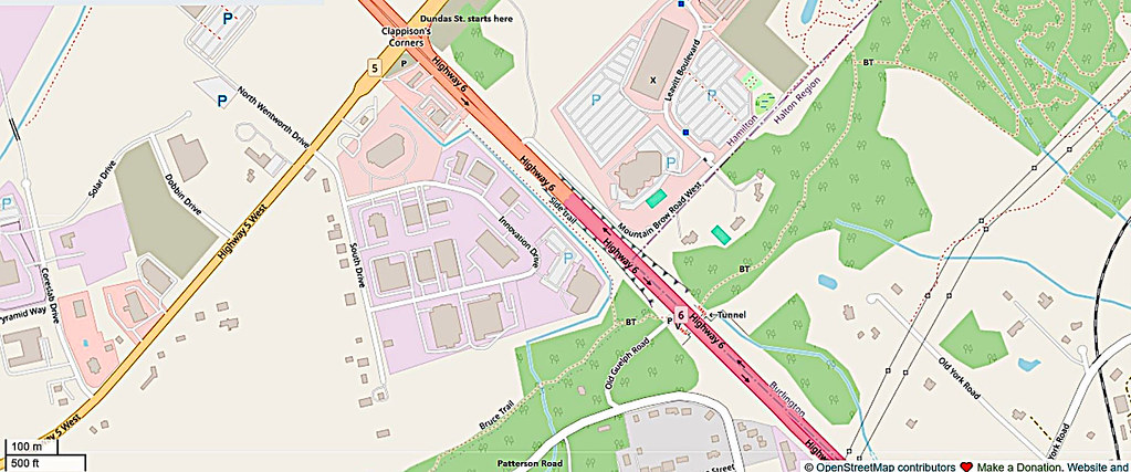
Map 19. At the eastern end of Patterson Road we take a left along a stub of Old Guelph Road. It ends abruptly at the formidable barrier that is Ontario Highway 6, where there’s a P and direct access to the Bruce Trail (BT). Back in the day, we’d have continued up winding Old Guelph Road as it ascended the Escarpment to Clappison’s Corners. But the Clappison Cut (see #211 below), has totally reshaped the landscape hereabouts. As pedestrians, we can take the tunnel under Highway 6 provided for hikers on the Bruce Trail. But though it’s only 700 m away, we cannot get up to Clappison’s Corners either on foot or by car directly any longer. (The “Side Trail” marked on the map above no longer exists.) We have to get back in our vehicle, drive back along Patterson Road to Valley Road, turn right, and take Rock Chapel Road to connect to Highway 5 a little way west of Clappison’s Corner (see Map 18 above). We’ll then creep forward, dwarfed by giant trucks, in a long line of traffic before turning into the gas station to P on the southwest corner of one of the busiest junctions in southern Ontario.

210. At the dead end of Old Guelph Road, there’s a view (V) of central Hamilton, with a sliver of Hamilton Harbour visible across the left centre of the image. The Mountain looms over the lower city.


211. (Top and bottom) The Clappison Cut was made in 1922. It involved blasting and gouging a roadway straight through the Niagara Escarpment. In the process, the continuation of Old Guelph Road with its three hairpin turns up the Mountain was replaced. More gouging took place later to widen the Cut and to guard against rock falls. These days the Escarpment is a UNESCO World Biosphere Reserve, but in 1922 there were few inhibitions about blasting through a cliff face nurturing the oldest forest ecosystem in eastern North America.

212. The Cut today. Ontario Highway 6, on the old border between West and East Flamborough, ascends the Niagara Escarpment directly. This view is from the York Road bridge, the only way across Hwy 6 for vehicles between here and Clappison’s Corners just over the rise in the distance.
Hwy 6, the main road between Hamilton and Guelph, also provides a 33 km connection between southern Ontario’s two main east-west highways, 403 and 401. Hwy 6 is notorious for bad accidents, being poorly designed for the amount of traffic it carries. True, this short section up the Mountain is properly divided, and boasts slip roads. But for much of the rest of its length between here and 401, Hwy 6 is undivided, with one centre turning lane for traffic in both directions. This arrangement practically invites head-on collisions. Hwy 6 north of here is also frequently intersected by unsignalized rural roads and private driveways, from which drivers must often wait for long, patience-trying minutes for gaps in the high-speed traffic. A right-angled turn onto Hwy 6 across the flow of traffic is a high-risk manoeuvre that many drivers avoid by long detours to the few signalized junctions. Five lanes dwindle to a two-lane bottleneck through the village of Morriston just south of the 401. And traffic southbound for Toronto must enter the 403 in the fast lane! It would be hard to deliberately design a more dangerous road, and that’s why Hwy 6 has earned the local sobriquet, the “Highway of Death.”

213. What of the Bruce Trail? Until recently, hikers somehow had to scamper across Hwy 6 without getting hit by a steady stream of vehicles coasting downhill at 100 km/h or more. (The descent is so steep most drivers find it difficult to keep to the 80 km/h limit.) The Bruce Trail Guidebook of 1985 notes, in bold: “use caution this is a 4 lane road.” Some understatement! Then in 2007 Hwy 6 was widened. A third slow inside lane was added on the uphill side to accommodate heavy trucks reduced to a crawl by the steepness of the ascent. And that’s when this 50 metre tunnel, a cast-in-place concrete culvert, was built, making it safe for hikers to cross. The roadbuilders also installed chainlink fences and a concrete median barrier to deter the suicidal from attempting to cross the road in the old way. The tunnel, meanwhile, is covered by graffiti, most of it sadly untalented. One hopes it’s well maintained. Any closure of this tunnel would render the Bruce Trail discontinuous, as there’s no nearby safe alternate pedestrian route across Hwy 6.

214. Drivers on Hwy 6 will have noted this huge new facility (X) on the east side just south of Clappison’s Corners. L3Harris is the sixth largest US aerospace and defense contractor, specializing in command and control systems. The plant here in Waterdown “designs and builds stabilized electro-optical and infrared (EO/IR) surveillance, targeting systems, and imaging solutions.” In plain English, this would seem to mean that they build high-tech systems enabling warplanes to detect and eliminate potential threats with precision.

215. Clappison’s Corners is not a place where you’d want to linger. The intersection between Highways 5 and 6 is extremely busy, especially with gravel trucks heading to and from local quarries. There are plans to construct a Hwy 5 overpass over Hwy 6 and a partial cloverleaf here. But none of this work is likely to reduce the current severe congestion. That’s because there are simultaneous plans to develop the commercial offerings in the northwest corner, to build a new supermarket and carpool lot on the southeast corner, and expand residential communities on the northeast corner. Construction of the new road configuration is supposed to take two years, so it will be advisable to avoid Clappison’s Corners for the duration. The trouble is, there are few alternative options for motorists, given that this junction is a nexus for major destinations at all four points of the compass.
As for us, we’ve reached the start of Dundas Street’s easterly extension to Toronto. Next stop: Waterdown.

