Part 12: To Old Fort Erie

137. On the American side of the Niagara River, the Ferry Street Bridge (1913) in Buffalo provides road access from the mainland to the southern part of Unity Island. A bascule bridge, it can be raised to allow vessels on the Black Rock Canal to pass under it. West Ferry Street has been renamed Robert Rich Way after the billionaire owner of Rich Products Corporation, the non-dairy/frozen food multinational, part of whose HQ can be seen behind.


138. On this side of the River, a plaque in Fort Erie marks the former location of the Bertie Street Ferry Landing. From 1796 through 1950, a ferry plied between Ferry Street in Buffalo and Fort Erie, though less frequently after 1927 when the Peace Bridge (see #142 below) was constructed. In the mid-nineteenth century, the ferry transported escaped slaves via the “underground railroad” to freedom in Canada (though not via Bertie Hall; see #131 above). The Newtown, a Niagara ferry photographed around 1920, took twenty minutes to cross the River. “Bertie,” by the way, refers to the former Bertie Township (1784-1970) that included Fort Erie and district. The Township was named after General Peregrine Bertie, Third Duke of Ancaster and Kesteven (1714-78), formerly Lord Great Chamberlain of the UK, the Officer of State in charge of the Palace of Westminster.
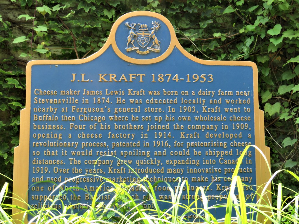
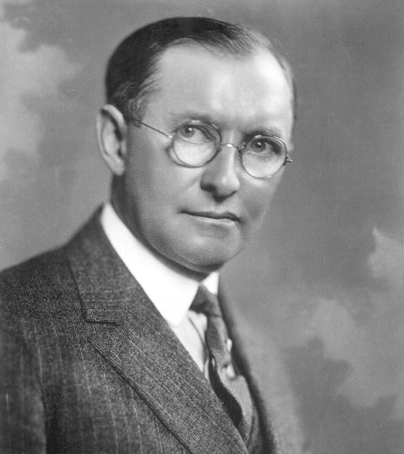
139. This plaque, partially hidden by tall grasses, is on the east side of Niagara Boulevard opposite Forsythe Street. James Lewis Kraft, a famous name in processed foods, was born the second of eleven children into the German community of Stevensville about 14 km west of Fort Erie. His parents ran a dairy farm from which they sold milk, eggs and cheese. From the age of 16 until he moved to the USA, Kraft clerked at Ferguson’s Store in Fort Erie, close to the Bertie Street Ferry Landing. His first company, J.L. Kraft & Bros. Co., specializing in cheese that had been chemically processed to preserve its quality, was founded in Chicago in 1909. Kraft was chiefly responsible for the large growth in American cheese consumption after World War I. Kraft Foods Group, the grocery division of Kraft Foods Inc., merged with Heinz in 2015 to form Kraft Heinz, one of the world’s largest food companies. The remaining division of the company, specializing in snacks, became Mondelēz International in 2012. Some of Kraft’s most famous brands include Miracle Whip, Kraft Dinner, Cool Whip, Cheez Whiz, Jell-O, Kool-Aid, Maxwell House, Philadelphia Cream Cheese, Shake ’n Bake, and Velveeta.
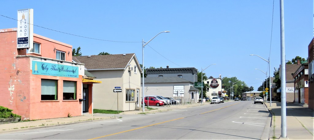
140. Fort Erie (pop. 31,000) is a town now in the Regional Municipality of Niagara, having absorbed several villages formerly in Bertie Township. At the moment, Niagara Boulevard downtown seems almost deserted and far from prosperous. That is possibly because Fort Erie depends on American tourists, and during the pandemic the land border has been closed to them for months.
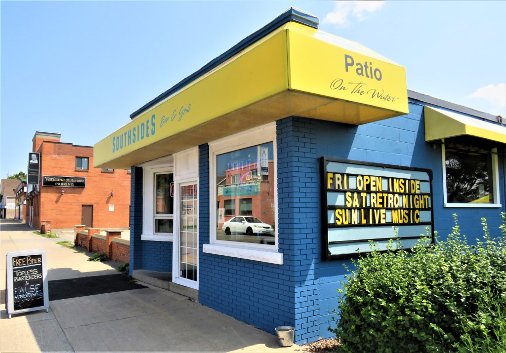
141. This bar and grill has a pleasant patio overlooking the Niagara River, where we lunched after the hike. What attracted us in the first place was the shameless message on the sidewalk chalkboard: FREE BEER, TOPLESS BARTENDERS & FALSE ADVERTISING.
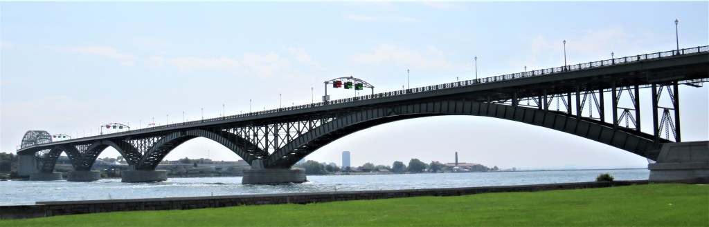

142. The Peace Bridge is the first fixed crossing of the Niagara River as it emerges from Lake Erie, and the second busiest of all the 119 border crossings between the USA and Canada. (The busiest is the Ambassador Bridge between Windsor, ON and Detroit, MI.) The Peace Bridge connects the QEW (and thus the Greater Toronto-Hamilton Area) to US Interstate I-190 in Buffalo, thence to I-90 west to Chicago or east to Boston and New York. The Bridge, opened to the public on 1 June 1927, is 1.77 km long, with five arched spans over the River and a truss span over the Black Rock Canal on the US side. There are three lanes of traffic on the Bridge, and red or green signs (lower image) indicate in which direction they are open. There are also two-metre-wide pedestrian sidewalks on either side. About 4,000 trucks cross the Bridge in both directions daily, over one million per year. Only this Bridge and the Queenston-Lewiston Bridge (about 27 km north by the QEW or 43 km on the Niagara Parkway, see #37 above) allow heavy trucks to cross the Niagara River. In non-pandemic times, you can cross the Peace Bridge by foot or bicycle. Pedestrians and cyclists pay no toll, nor do motorists entering the USA, but there’s a US $6.00 fee to enter Canada by car. From 9 August 2021, Americans who are fully vaccinated and have a negative Covid test taken within 72 hours of arriving at the border can enter Canada and do not require further documentation to return to the USA. Canadians without special permission are as yet forbidden from entering the USA by road.

143. The downtown Buffalo skyline isn’t very far away, but smoke from forest fires in Northern Ontario pervades the atmosphere, reducing the buildings almost to silhouettes. The skyscraper on the right is the tallest building in the city: Seneca One Tower (1972; 161 metres), occupied chiefly by the M&T Bank Corporation.

144. Zoomed in as close as the camera allows, Buffalo’s epic art deco City Hall (completed 1931, 121 metres) looms through the murk. It’s the third tallest building in the city and one of the largest municipal buildings in the USA, hearkening back to the time when Buffalo was the world’s largest grain port and a wealthy hive of industry. After years in the doldrums of the Rust Belt, Buffalo today, still the second largest city (pop. 280,000, metro 1,200,000) in New York State, is slowly starting to emerge as a post-industrial destination with a large range of cultural and sporting offerings.

145. The Niagara River Trail is now this pleasant path towards Old Fort Erie through parkland along the shore of the Niagara River where it emerges from Lake Erie.

146. Seemingly far from land in any direction sits the Buffalo/Emerald Channel Water Intake Building (1907), which provides the City of Buffalo with 125 million gallons of drinking water per day. (“Emerald Channel” describes the purity of the water at this spot between lake and river.) Water enters the round building through grates and collects in a circular pool. From there it drops 20 metres to a concrete tunnel under the river bed from where it is conducted by gravity to the Colonel Ward Pumping Station on the mainland where it is treated and sent throughout the city. On the building’s red roof is a light to warn passing vessels.
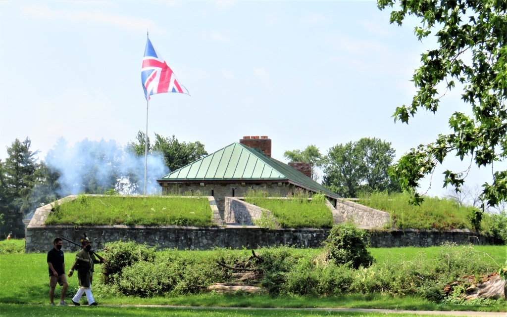


147. (Top image) We are startled by a sudden explosion! Smoke marks the spot where a cannon has just been fired near the main gate (middle image) of Old Fort Erie. In the top image we see the west (kitchen) end of the main interior buildings, defended by a demi-bastion and, in the foreground, an abatis of tree branches. This strategic location where the Niagara River flows out of Lake Erie was first fortified by the British in 1764. During the War of 1812, the bastion that occupied this elevated position opposite Buffalo was actually the third Fort Erie. It was constructed from 1805-08 from Onondaga limestone, a seam of hard Devonian dolomite that runs along the northern Erie lakeshore at this point. The Fort was still unfinished when the War of 1812 began. The Americans captured and occupied it briefly in 1813, but it was the next year that cemented its place in history. The Americans with about 2,800 men recaptured Fort Erie on 3 July 1814, and after the bloody stalemate of the Battle of Lundy’s Lane on 25 July, they retreated to the Fort, and were ordered to hold it as a bridgehead for a further invasion of the Niagara Peninsula. The Fort was then besieged for seven weeks by a British force under Lieutenant General Gordon Drummond of about 3,000 men including native allies. Drummond led a poorly planned night assault on the Fort on 15 August, to encounter withering fire from the Americans under Brigadier General Edmund Gaines. The northeast bastion was captured by the British, but by accident or design the ammunition magazine beneath it blew up with a tremendous explosion, killing or wounding over 900 British troops and 62 Americans (see bottom image). A further British attack on 17 September led to at least 500 Americans and over 600 British and allies killed or wounded. It is this combined casualty count that has earned Old Fort Erie the title of “the bloodiest battlefield in the history of Canada.” On 21 September Drummond lifted the siege and withdrew to Chippawa. On 5 November the Americans, having failed to make further inroads into Upper Canada, destroyed the Fort before retreating to Buffalo. The current Old Fort Erie is an elaborate and impressive reconstruction made between 1937-39 of how the Fort was thought to look during the War of 1812. For fuller military details of the Siege, see Mike Phifer, “Old Fort Erie: The Defiant Stand during the War of 1812″ in Warfare History Network.
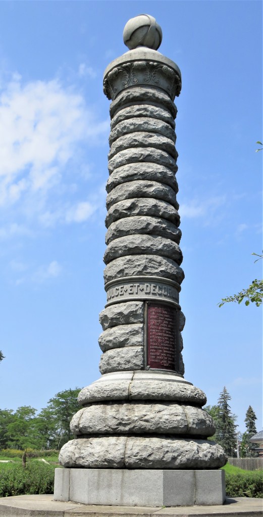
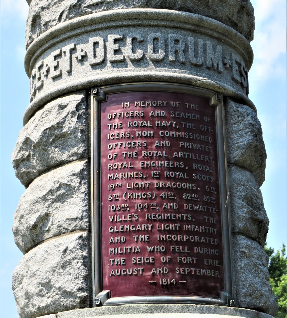
148. A nine-metre-tall monument to the dead at Old Fort Erie was erected in 1905. Around the column is carved in relief the Latin inscription, DULCE ET DECORUM EST PRO PATRIA MORI. This means, “it is sweet and fitting to die for one’s country,” and is a quotation from a poem in the Roman poet Horace’s third Book of Odes (23 BC). But there was nothing sweet or fitting about the deaths on either side at Old Fort Erie. (A posthumously published antiwar poem from World War I entitled “Dulce et Decorum Est” (1920) by Wilfred Owen may have destroyed for good the force of the ancient martial sentiment.) Check out Pierre Berton’s graphic description of the Siege (usually spelled thus) of Fort Erie in his history of the War of 1812, Flames Across the Border (1981).

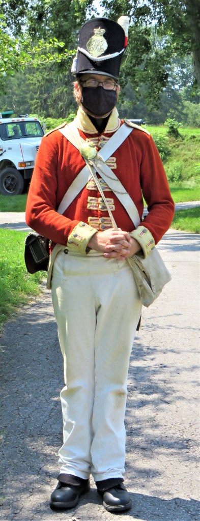
149. Staff in historical costume with orders to be friendly to visitors form one of the appeals of the Old Fort to tourists today, though it must be very uncomfortable to dress up like this while wearing a mask on this hot, humid day. In the greenish coat is a US infantryman with musket, who nevertheless assures us that he is really a proud Canadian. His redcoated counterpart is dressed as a British private of the period. It wasn’t until 1902 that the British Army exchanged their highly visible scarlet uniforms for khaki service dress. The famous scarlet dress uniforms of the Mounties are a legacy from the days of the British redcoats.
To check out more pictures and commentary about this area, please go to my photoblog on Skyscraper City, where you’ll also find shots of the Buffalo skyline on a clear day and many more images from both inside and outside Old Fort Erie.
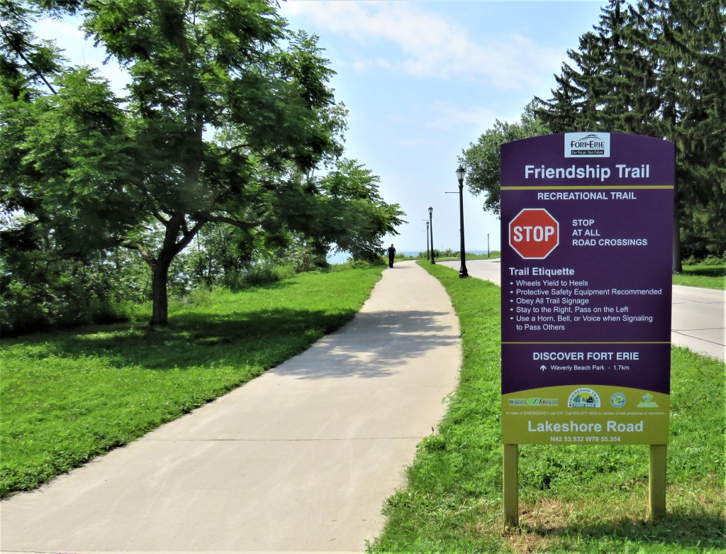
150. Here by the side of Lakeshore Road the Niagara River Trail ends and the Friendship Trail begins. The latter runs for about 25.8 km chiefly on the bed of a disused rail line from here to Welland Street in Port Colbourne. We plan to explore this Trail to see whether it has enough interest for another feature. In the meantime, many thanks for following us along the historic Niagara River Trail.
