
Hike: 1
Date: Thursday 3 December 2020
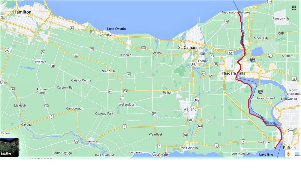
Start: Nelson Street at Ricardo Street, Niagara-on-the-Lake
End: Queenston Heights Park, Queenston
Distance Covered: 12.1 km
Total Distance Covered: 12.1 km
Part 1: South from Niagara-on-the-Lake
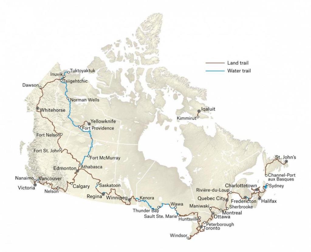
1. It’s December 2020 and having completed the Bruce Trail last month, Mike and I are up for a new challenge. The Great Trail of Canada, known until 2016 as the Trans Canada Trail (TCT), is next on our list. It’s 27,000 km long, the most extensive multi-use trail network in the world, and several branches of it pass by the Hamilton area. However, the Great Trail is nothing like the Bruce Trail, the Appalachian Trail, or other famous North American hiking trails. For a start, two-thirds of it runs on public highways, quite a lot of it is “water trail” to be navigated by canoe rather than on foot, none of it is owned by TCT (now the name of the organization that promotes the Great Trail), and “multi-use” means that it is intended to be shared with people doing a variety of activities that may or may not include hiking.
2. No, we have no intention of attempting to complete all 27,000 km of the Great Trail. It’s 30 times the length of the Bruce Trail, so it would take us about 75 years at our usual pace. As our current combined age is 141 years, I don’t need to spell out why a Great Trail End-to-End would be a bridge too far. What we plan to do is explore some local Great Trail highlights. One of the more appealing sections begins in Niagara-on-the-Lake and follows the Niagara River south (that is, upstream) via Niagara Falls to Fort Erie. We’ll follow this trail for more than 50 km, starting at Ricardo Street just east of downtown Niagara-on-the-Lake and finishing on the shore of Lake Erie. See the red line on the map above.
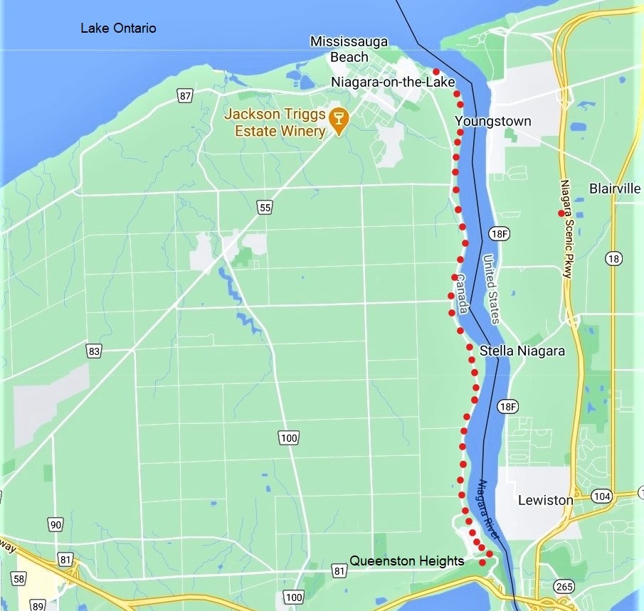
3. Our first leg (the red dotted line) will take us from the charming town of Niagara-on-the-Lake (pop. 17,500), known for its Shaw Festival theatres, past several historic riverside sites, through the village of Queenston, as far as the monument to Laura Secord on Queenston Heights.

4. Several other Trails also lay claim to this section of riverbank, and all of them are older than the Great Trail. The Waterfront Trail is the first to announce itself with a waymarker. It’s a trail that follows the St. Lawrence River westward from the Québec-Ontario border, then continues along the north shores of Lakes Ontario and Erie. Much of it is on public roads, so it’s more suitable for cyclists than for pedestrians. If we followed the arrow and kept going, we’d eventually come to Windsor, Ontario, across the river from Detroit, Michigan.

5. We find the Niagara River Recreation Trail to be the most consistently waymarked. It’s a paved, segregated path for non-motorized traffic that runs mostly alongside the scenic, two-lane Niagara River Parkway for 53 km. This is essentially the Trail that we’ll be following. And though there are no blue blazes visible yet, the section of trail we’re hiking today is almost identical to the 12.4 km General Brock Bruce Side Trail, which connects with the main Bruce Trail at the latter’s southern terminus at Queenston Heights.

6. So what about the Great Trail? Well, the only trace of it we could find as we started out were the words “Trans Canada Trail/Sentier Transcanadien” inscribed in green letters on this large rock lying by the side of the Trail near Fort George. Under the rock is a time capsule that was buried in 2017 to mark the 150th anniversary of Canadian Confederation, and is not to be opened until 2067. What’s in the capsule? A flag, a few T-shirts, and a lot of pamphlets. Nothing for alien visitors to Earth in 2067 to get excited about.

7A. We pass Fort George behind its palisade. It was built in 1796 to replace the loss of Fort Niagara (see 7B), ceded to the USA the previous year by the terms of the Jay Treaty. This pact sought to deal with unresolved issues between Britain and the USA resulting from the American Revolution. One of these issues was better defining the border between British North America (now Canada) and the United States. During the War of 1812, Fort George was captured by the Americans in May 1813, but they abandoned it in December of that same year.

7B. Fort Niagara (viewed from Niagara-on-the-Lake) is a large stone installation on the American side of the Niagara River where it enters Lake Ontario. It was built by the French but fell to the British after a siege in 1759. Though officially ceded to the USA after the Revolutionary War, it didn’t actually change hands until after the Jay Treaty was signed. These days it’s known as “Old Fort Niagara” and is the focus of a New York State Park where popular historical military reenactments take place.

8. The Niagara River looking upstream on this mild day in early December with a sprinkling of snow on the ground. Here on the Canadian side, the Niagara River Recreation Trail hugs the river’s western bank, and a short section of the Niagara Parkway is visible at centre right. It’s a peaceful scene, unusually so in that the many tourist vehicles that normally cruise the Parkway are absent due to the Covid-19 pandemic.
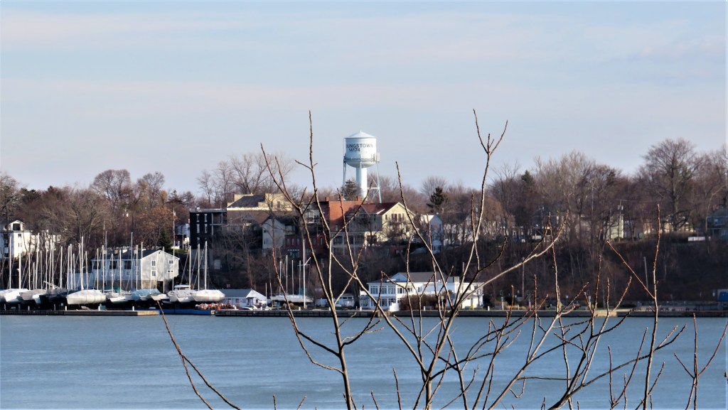
9. The river here is about 500 m wide, and rural on the Canadian side now that we’ve left behind the not-very-extensive suburbs of Niagara-on-the-Lake. On the American side is Youngstown (pop. 2,000), a village in Niagara County, New York State. While all seems quiet now, that wasn’t the case more than two centuries ago. Though the Jay Treaty had brought several years of peace, the Americans, provoked by high-handed British naval actions during the Napoleonic Wars, invaded British North America in 1812 with the intention of claiming the colony for themselves. They burnt Newark, as Niagara-on-the-Lake was then called, to the ground in 1813; in retaliation the British and their First Nations allies burnt Youngstown and vicinity. Many key events in the War of 1812, as the conflict came to be known (it actually lasted until early 1815), occurred on or near the banks of the Niagara River within a few kilometers of today’s hike. The War ended in a stalemate, though the existence of Canada as an independent nation today can be traced to the failure of the Americans to retain the territory they conquered during the conflict.
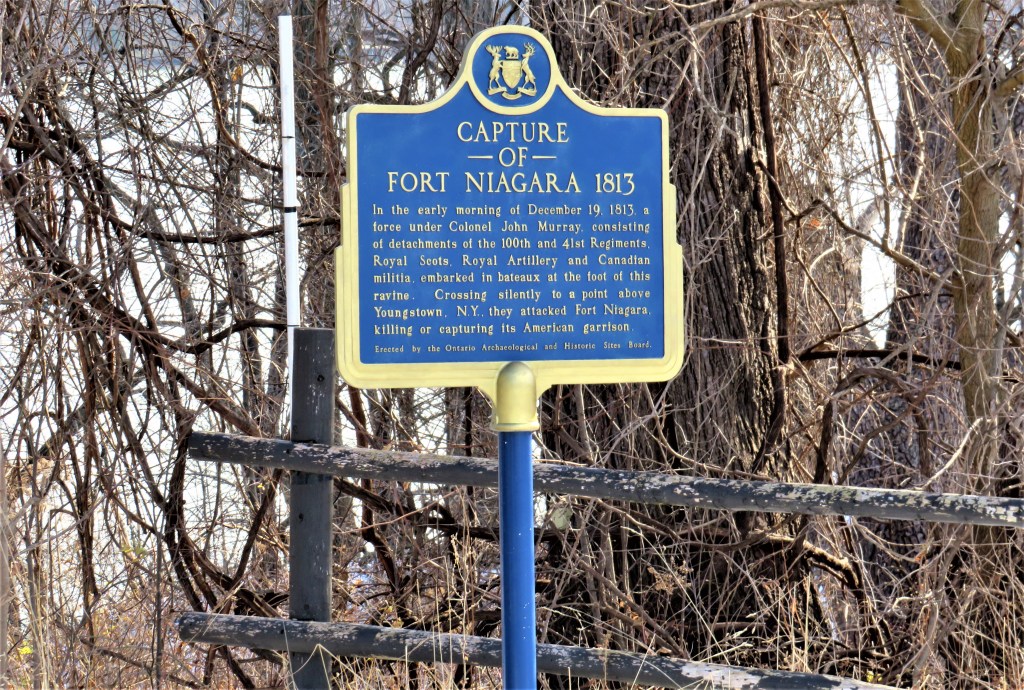
10. A plaque framed by the west bank of the Niagara River memorializes the capture of Fort Niagara by the British nine days after the burning of Newark by the Americans. This action led to 65 Americans dead and 16 wounded, all by bayonet, and 350 captured, with 6 British dead and 5 wounded. Though the casualty list in the War of 1812 seems short by later standards, the conflict was often extremely brutal. The use of bayonets, rather than firearms, in the capture of Fort Niagara was part of the successful British strategy of stealth alluded to on the plaque: letting off firearms would have given away their position too soon. The British held Fort Niagara until the Treaty of Ghent, ending the War of 1812, came into effect.

11. John McFarland (1752-1815), a ship’s carpenter, was born in Paisley, Scotland. He was an expert on the selection and cutting of timber in the Niagara Peninsula and later went successfully into business as a timber merchant. By 1800 he had built a brick kiln and with homemade bricks built this house for himself, his second wife, and his ten children on what was then called River Road, now the Parkway. During the American capture of Fort George, McFarland and his son James were taken prisoner and sent to Greenbush internment camp, near Albany, NY. James escaped, and served as one of Colonel John Murray’s guides when the British captured Fort Niagara. John McFarland’s health was ruined at Greenbush and his brick house was badly damaged during the War of 1812. He died in late 1815, and was buried in St. Mark’s churchyard in Niagara-on-the-Lake. His children restored the building, and today the McFarland House (rear view above) is a museum and tea room (currently closed by the pandemic).
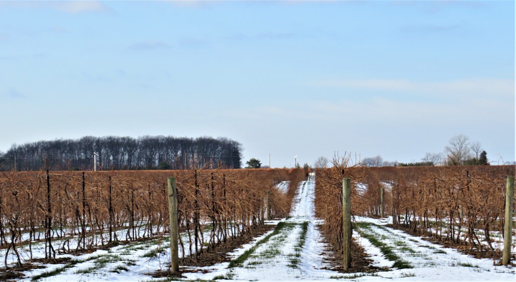
12. On the other side of the Parkway from the River are vineyards. The Niagara Peninsula is Ontario’s leading wine region, and there are more than thirty wineries in the vicinity of Niagara-on-the-Lake alone.
