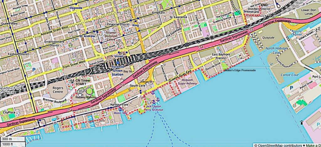
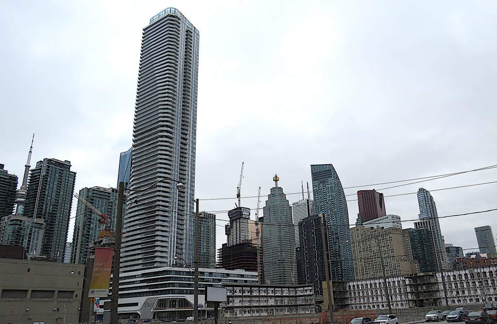
131. Today’s hike goes from the foot of the CN Tower (START) on the map above to the Distillery District (END). It’s about 3.2 km if you go straight east along the Martin Goodman/Waterfront Trail. But if you follow my devious route (the red dots on the map) to take in some of the sights between Queens Quay and the waterfront, it’ll be twice as long and may take you most of the day. This is, after all, the central part of Canada’s biggest city, now the fourth largest in North America after Mexico City, New York, and Los Angeles, so there are plenty of metropolitan diversions on offer … and innumerable opportunities for rest and refuelling breaks. Though the route will be busy with pedestrians in good weather, you won’t have to negotiate much vehicular traffic, aside from a few aggressive cyclists on the MGT.
Don’t attempt to park anywhere here. Take the subway to Union Station to start the hike, and get a bus back to Union (or wherever) at the end. Let the TTC website be your guide.
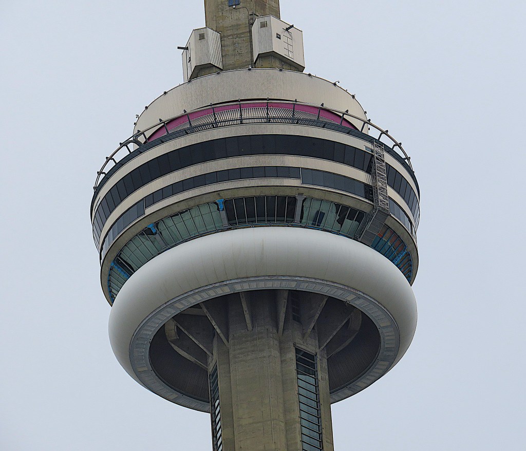
132. Our hike begins and ends under the watchful gaze of a monster. This is the main pod of the CN Tower. You can see the external overhead rail that secures the thrill-seeking EdgeWalkers as they shuffle around the 1.5 metre-wide ledge (though they’re absent today). Below that is the 360 Restaurant, rotating once every 72 minutes. Under that is the Main Observation Deck at 346 metres. Beneath that, the Lower Observation Deck has a glass floor that you can stand or sit on, a pane 6.3 cm thick separating you from the abyss.
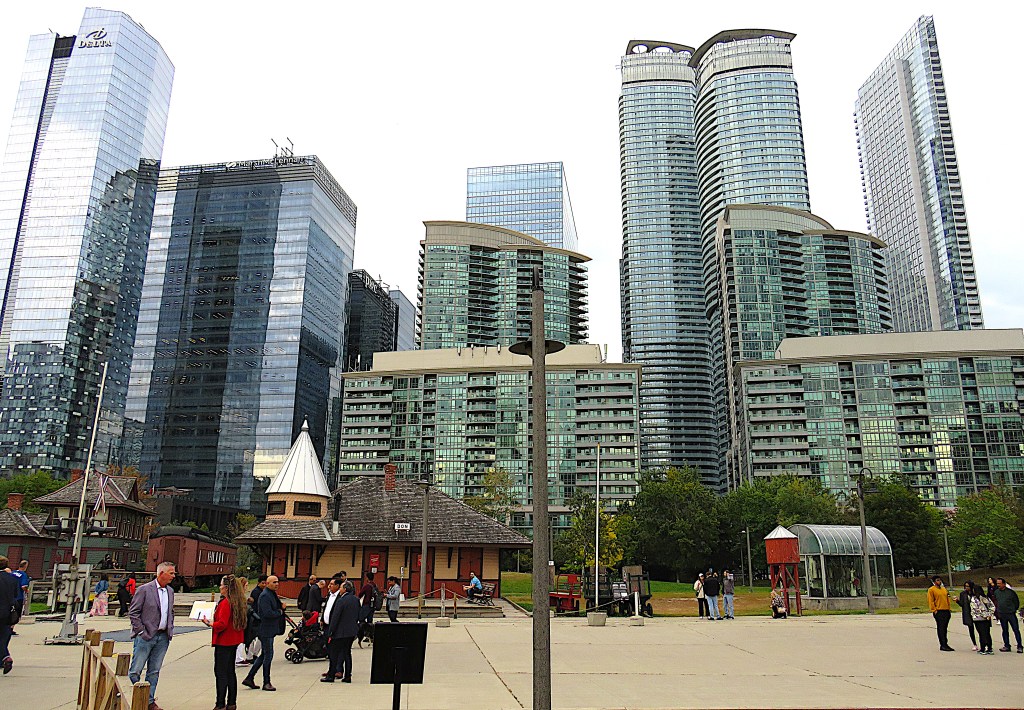
133. Just over Bremner Blvd., south-east of the foot of the tower, is a large circular space partly occupied by a former railway roundhouse. Here’s the Toronto Railway Museum for train fans. If you are just passing through like me, there are external exhibits on view, such as old station buildings, toylike against the backdrop of glistening high-rise hotels and condos.
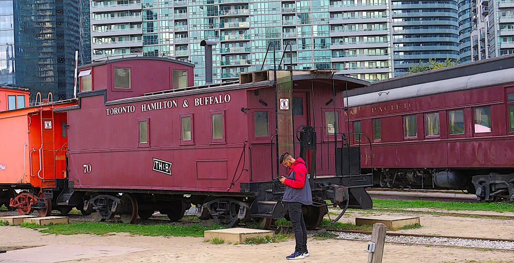
134. There’s also some antique rolling stock on view for free outside the museum, including this purple caboose. The Toronto, Hamilton & Buffalo Railway ran from 1892 to 1987, when what was left of it was merged into the Canadian Pacific system. The name “TH&B” was entirely misleading because, while the company was based in Hamilton, its network never reached either Toronto or Buffalo. Its acronym was sometimes decoded as “To Hell and Back.”
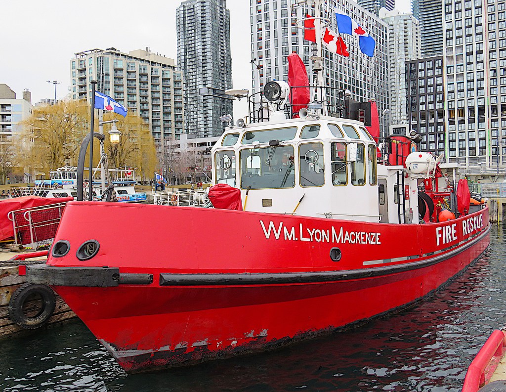
135. Let’s head south via Rees Street to the waterfront then go west a little to catch a couple of sights we bypassed on the previous hike. By the Toronto Fire and Marine Station in HTO Park is the William Lyon Mackenzie (built 1964), Toronto Harbour’s main fireboat and icebreaker. The vessel is named for the Scottish-born first mayor of Toronto (1795-1861, in office 1834-35), more famous/notorious these days for leading an abortive armed rebellion to achieve political reforms in Upper Canada.
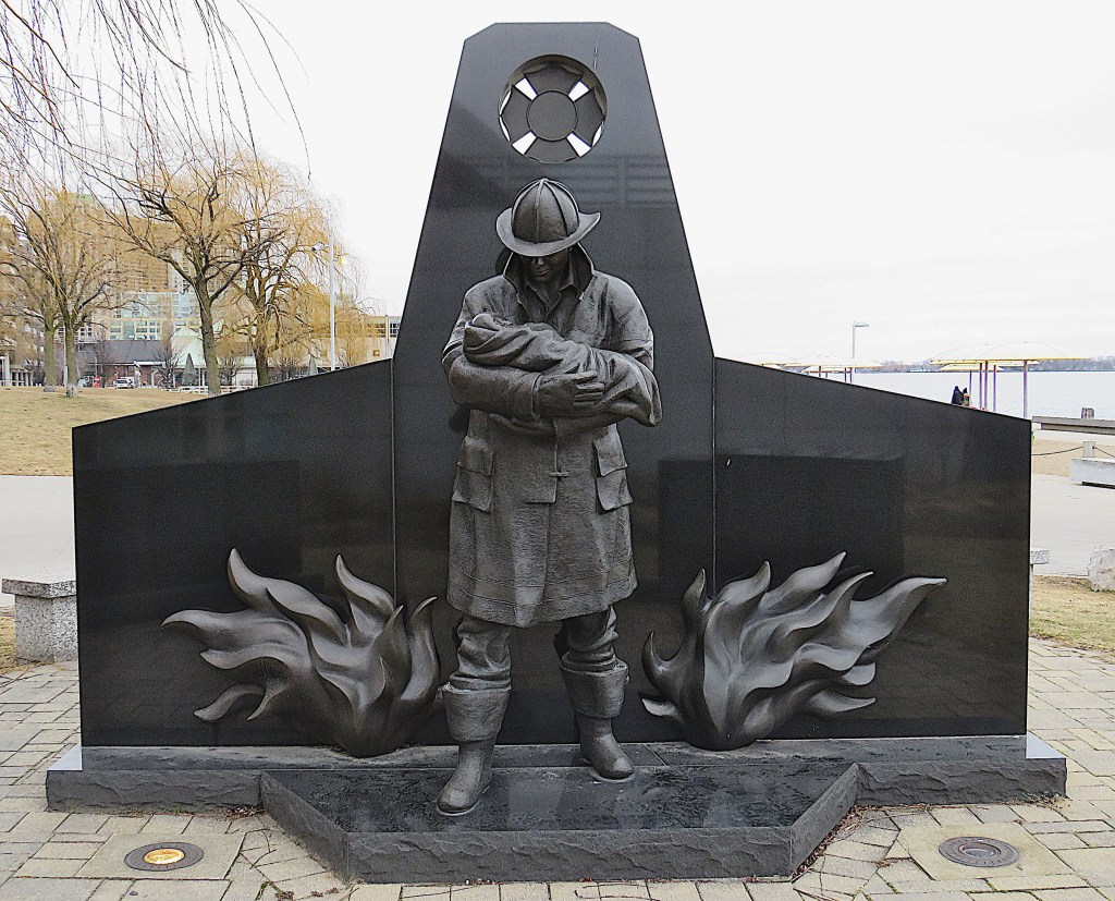
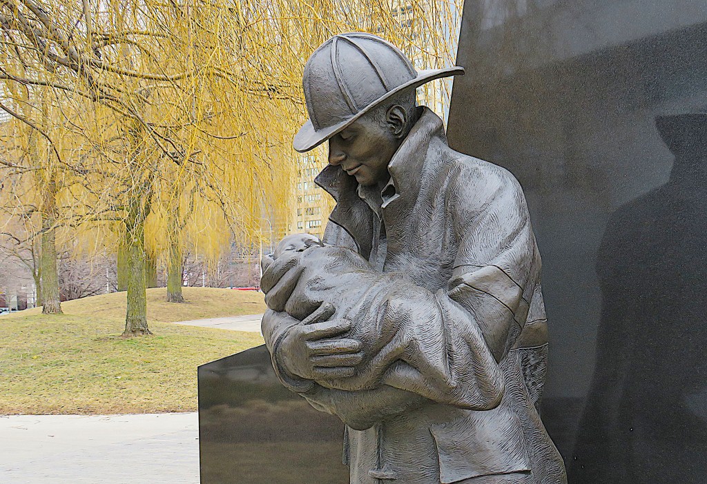
136. We’ve already visited a number of sculptural memorials along the waterfront. This may be the best. It’s Last Alarm (2000) by Yolanda vanderGaast (Canada), located just east of the Toronto Fire and Marine Station. A monument to Toronto firefighters killed on duty, it represents a firefighter having rescued a baby, flames lapping at his feet. On the reverse is a list of names and dates of the more than 200 Toronto firefighters fallen since 1848.
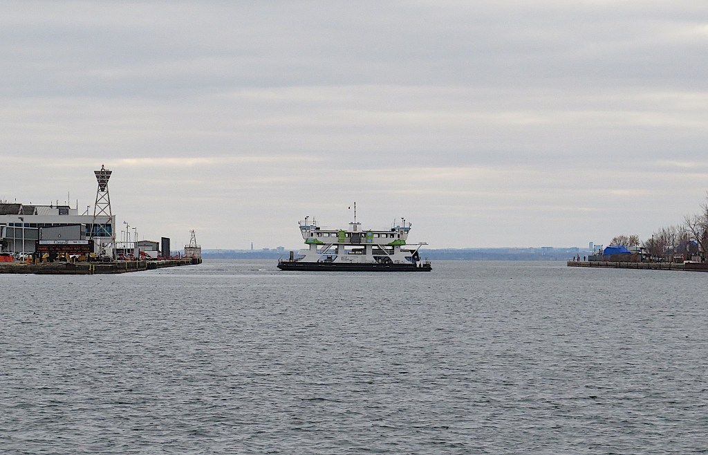
137. If you stand on the lakeshore in HTO Park and look west, you get a good view of one of the world’s shortest ferry rides. The electric-powered Marilyn Bell I plies the 121 metres between the mainland and Billy Bishop Airport in 90 seconds. The ferry runs every 15 minutes and is free to pedestrians.
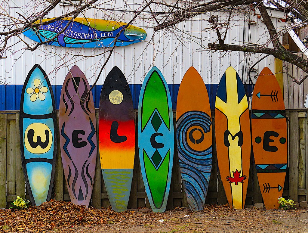
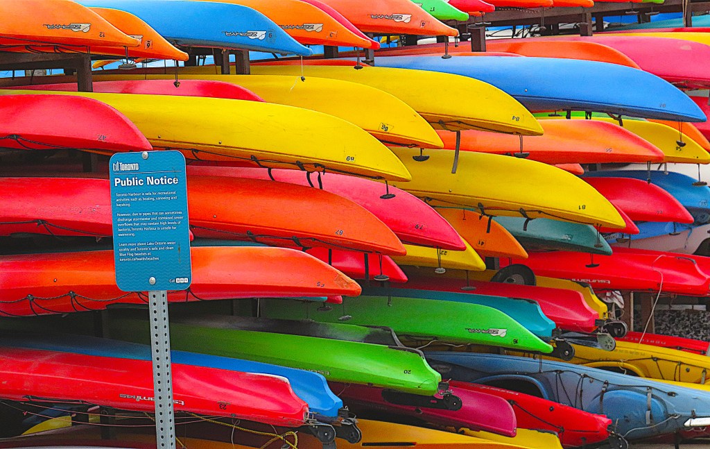
138. South of Queens Quay West near the foot of Rees Street are welcome splashes of colour on a dull winter’s day. During the warmer months, Toronto’s waterfront is busy with canoeists, kayakers, and stand-up paddleboarders.

139. This trilithon, Gateway to Understanding, looms numinously near the waterfront just west of Police Basin. It’s a “clonehenge” by the Inuvialuk sculptor David Ruben Piqtoukun (b. 1950 in Paulatuk, Northwest Territories). He describes its purpose thus: “Through dialogue and cultural exchange, tolerance and understanding awaken within us. This structure will stand tall and bold as a symbol of the Earth Spirit.”
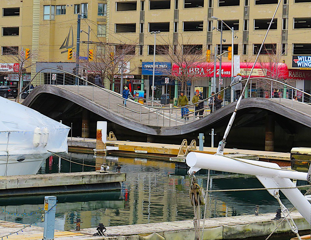
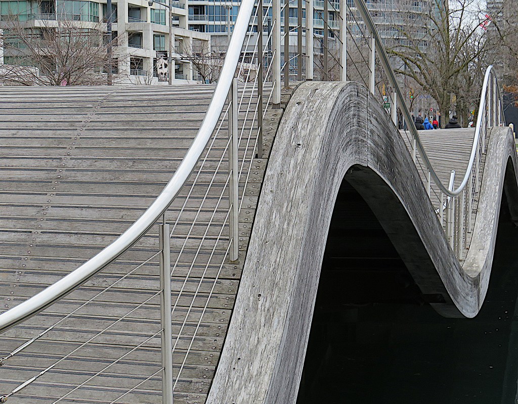
140. There are three “wavedecks” along this stretch of the Trail, of which the one west of the foot of Lower Simcoe Street is the most striking. According to its official description, “The Simcoe WaveDeck created new public space at the water’s edge by replacing a narrow sidewalk with a grand waterside gathering place … The 650-square metre structure features two large swells with slender stainless steel railings that follow the undulations of the waves in the deck. These railings are designed to differentiate the curved portions of the deck and help visitors negotiate the slopes.” Reading between the lines, one gathers that the wavedecks have no other function than to provide a visually appealing setting suitable for being photographed then posted on social media. In short, they are Instagrammable.
141. The Power Plant is a free-to-enter contemporary art gallery at Harbourfront Centre. The building is one of the few relics of the industrial past in this part of Toronto Harbour. It was built in 1926 to house the heating and refrigeration equipment for the adjacent Toronto Terminal Warehouse, a huge storage facility for goods incoming to the Port of Toronto. That building has now been transformed beyond recognition into Queens Quay Terminal, a commercial and residential complex.

142. There were a couple of exhibits of interest when I visited. This is a detail from The Chess Game (2022) by Anna Boghiguian (Egypt-Armenia-Canada, b. 1946). According to the curators it depicts “an oversize chess board with cutouts of historical figures from opposing and correlating schools of thought caught in an intellectual exchange.” The two-dimensional caricatures are crude and I didn’t recognize most of them. But the ensemble is colourful and eye-catching, and another dimension is provided by daylight from big windows hitting the board’s reflective surfaces. Through the windows, you glimpse a tall ship moored at the quayside.
143. The other interesting exhibit was Solastalgia: Archaeologies of Loss, a series of semi-abstract images by Abdelkader Benchamma (France, b. 1975). “Gestural and lyrical, as well as dense and detailed, Benchamma’s predominantly monochrome murals are abstractions of tectonic movements and gravitational forces that harness the dynamism of the universe.”
144. Decorated by swirly Benchamma murals, the rear hallway of the gallery is illuminated by the large window giving onto the harbour. Through it, that same tall ship is visible …
145. … it’s Kajama, a three-masted schooner that offers cruises and educational programs for up to 225 passengers during the spring and summer. The rest of the year she can be found moored here at 235 Queens Quay West. She was built as Wilfried in 1930 in Germany, then in 1960 was bought by a Danish captain who renamed the vessel using a composite of his wife’s and children’s names. In 1998, he suffered a fatal heart attack at the helm, causing the ship to run aground near Malmö, Sweden. Kajama was brought to Canada in 1999 and refitted for her current touristic role.
146. The MGT (here designated the Waterfront Recreational Trail) near the foot of Lower Simcoe Street looking east. From left to right: Queens Quay West, the TTC streetcar tracks, the Trail for bikes, the sidewalk for pedestrians.
147. This is the oldest building (1907) currently standing on the waterfront. The light blue name plaque is misleading: the Toronto Harbour Commission is a six-story building on Harbour Street, now several blocks inland. This is a former freight shed that was relocated here at Pier 6 in 1989. It’s now a gift shop, a ticket office for Harbour tours, and an outlet for BeaverTails. For the uninitiated, these last are sugar-coated fried dough shaped like a beaver’s rear appendage.
148. This colourful water bird off Pier 6 is a male long-tailed duck (Clangula hyemalis). His white head and dark cheek patch indicate winter plumage; in summer his head is dark with a white cheek patch. The pointy tails of these ducks can be up to 15 cm long. Thousands of these sea ducks winter in sheltered areas of the Great Lakes.
149. A billboard – or is it a mural? – above the TTC station at Bay Street and Queens Quay W. Though underground, this station is not part of the Toronto subway but a node on the streetcar line along the waterfront between Union and Exhibition Stations.
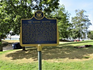
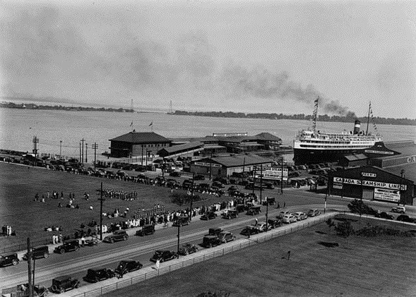
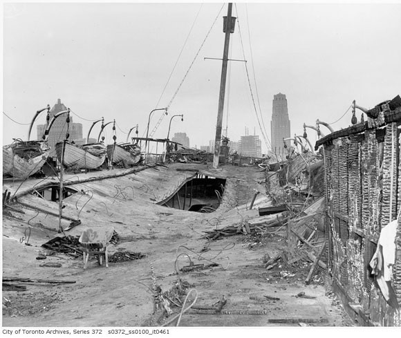
150. (Top) This plaque at the lakeshore near the foot of Yonge Street commemorates Toronto’s deadliest manmade disaster. (Middle) SS Noronic (launched 1913) was one of the grandest Great Lakes cruise liners of her time. On the night of 16-17 September 1949 she was tied up at Pier 9 with 524 passengers, all but 20 of them Americans. All but 15 of the 171 Canadian crew were ashore. A small fire that started at 2:30 am in a linen closet caused the ship to burst into flames “like a paint factory,” and in eight minutes she was engulfed. (Bottom) Her top deck in the aftermath of the fire. (Middle and bottom images courtesy of City of Toronto Archives.)
At that time shipboard safety regulations were nonexistent. The few crew members aboard Noronic had no emergency training and failed to wake the passengers or call the fire department; none of the onboard fire hoses worked; only the lowest of the Noronic’s five decks had gangways ashore; and her hallways were lined with wood that had been polished with lemon oil. At least 118 passengers and one crew member perished, many of them burnt beyond recognition. Others were suffocated, trampled to death, killed falling from upper decks, or drowned. As several passengers were travelling under false names and no record was kept of overnight visitors to the ship, the death toll was never finally determined. The City of Toronto fireboat, which had a wooden hull (!), was partly damaged putting out the fire. (It was eventually replaced by the William Lyon Mackenzie, see #135 above.) The Noronic disaster practically destroyed the cruise industry on the Great Lakes.
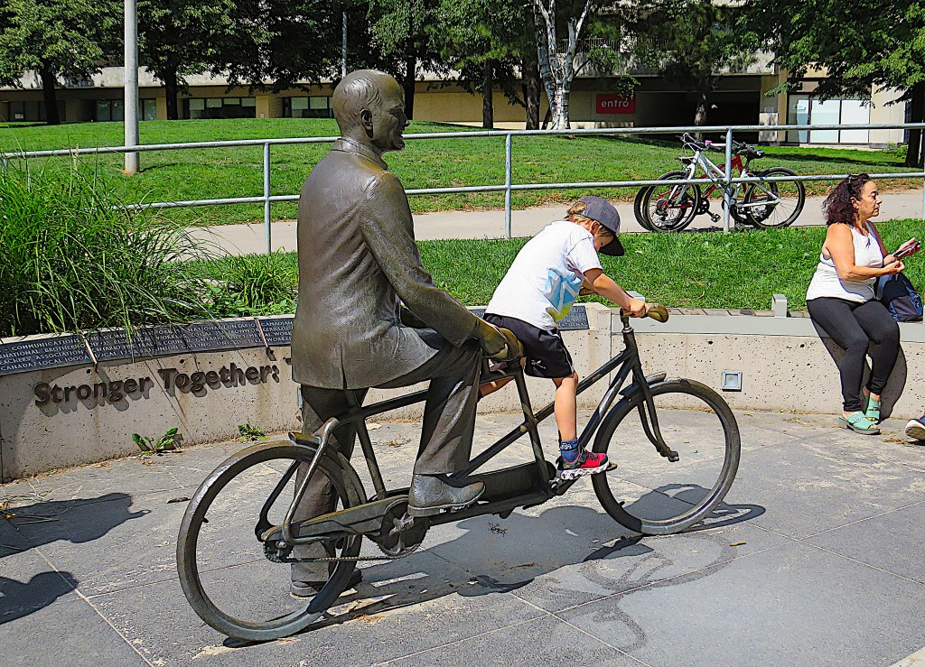
151. The Jack Layton Memorial stands at the foot of Yonge Street near the Ferry Terminal that also bears his name. Fully Instagrammable, the bronze is by David Pellettier (Canada, b. 1950).
Jack Layton (b. 1950 in Montreal) was a popular and well-regarded progressive Toronto councillor and later MP and Leader of the New Democratic Party. In the general election of May 2011, the NDP under Layton won an unprecedented number of seats and Layton found himself Leader of the Opposition. Sadly, he died of cancer at the age of 61 in August that same year.
Layton was a cycling advocate in a city notorious for traffic congestion and lengthy commute times. Though some segregated bike paths have been installed recently, Toronto remains a relatively dangerous city for cyclists. Layton’s widow Olivia Chow, who used to ride with him on their tandem bicycle, is currently mayor of Toronto.
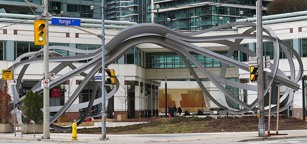
152. The huge abstract metal sculpture Between the Eyes (1990) by Richard Deacon (UK, b. 1949) sits at the northwest corner of Queens Quay West and Yonge. From an interview with the sculptor: “The two bulbs are different. One is symmetrical and the other is kind of extruded on one side. The real reason for that is purely to … give a kind of narrative and a liveliness between the two parts … The sculpture itself is joined by something like a tendon or a thread or a trunk, a root, even a ganglia that knots the two parts together” (courtesy of Artworx:TO, City of Toronto).
Something other than two giant egg-beaters joined at the handle might have been better suited to this location …
153. … which is a pretty significant one. This is where Yonge Street ends at the Harbour. Yonge is Toronto’s “main street,” the longitudinal baseline where latitudinal streets change their designations from West to East as they cross it. 1.7 km north of here, Yonge’s intersection with Dundas Street, the most historic latitudinal road in Toronto, is considered the centre of the modern metropolis.
Yonge Street was planned by Upper Canada’s first lieutenant governor John Graves Simcoe as a straight military route from his newly designated capital of York to Lake Simcoe. It was thus an upgrade to the ancient indigenous canoe route known as the Toronto Carrying-Place Trail connecting Lake Ontario and Lake Simcoe.
Simcoe named the street after Sir George Yonge (1731-1812), an English friend of his who was an expert on Roman roads (and who never visited Canada). That’s because Simcoe viewed his Canadian road-building project as akin to that of the Romans in Britain almost 2,000 years earlier. Yonge Street was begun in 1794 but did not become passable along its whole length until 1816.
Yonge Street has erroneously been called the longest street in the world. Actually it’s a mere 68.2 km from here to its north end in East Gwillimbury, then there is a discontinuous 29.4 km section that goes farther north to Barrie. The name “Yonge Street” is not used thereafter. By contrast, the Pan-American Highway is about 30,000 km long.
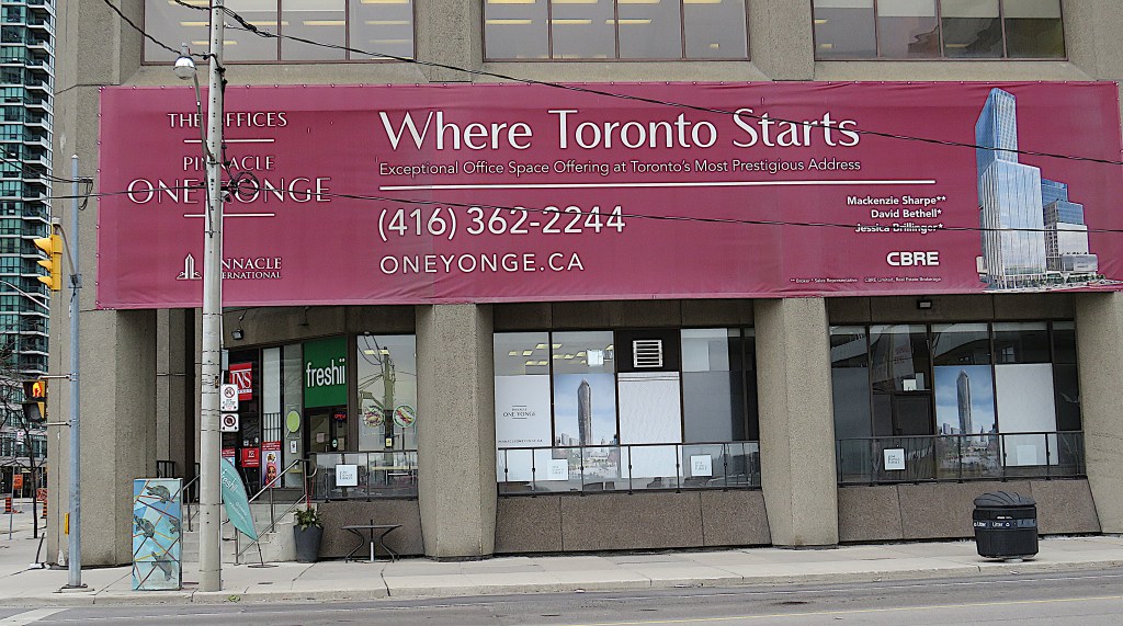
154. One Yonge Street is certainly a memorable Toronto address, though it’s hardly prestigious at the moment. In fact the building that currently occupies the site is architecturally quite undistinguished. From 1971 to 2022 it was the HQ of Torstar, the publisher of the Toronto Star newspaper. Torstar has now moved out and the building is waiting to be demolished and the site redeveloped as Pinnacle One Yonge. SkyTower, one of the proposed six skyscrapers to be built on this site, would be at 346 metres the tallest habitable building in Canada.
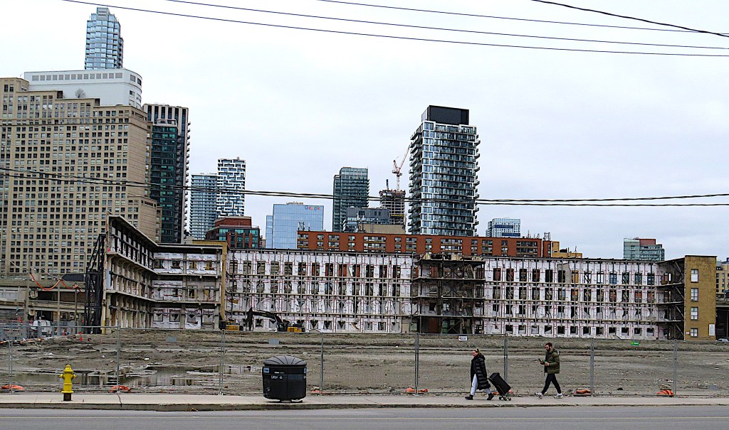
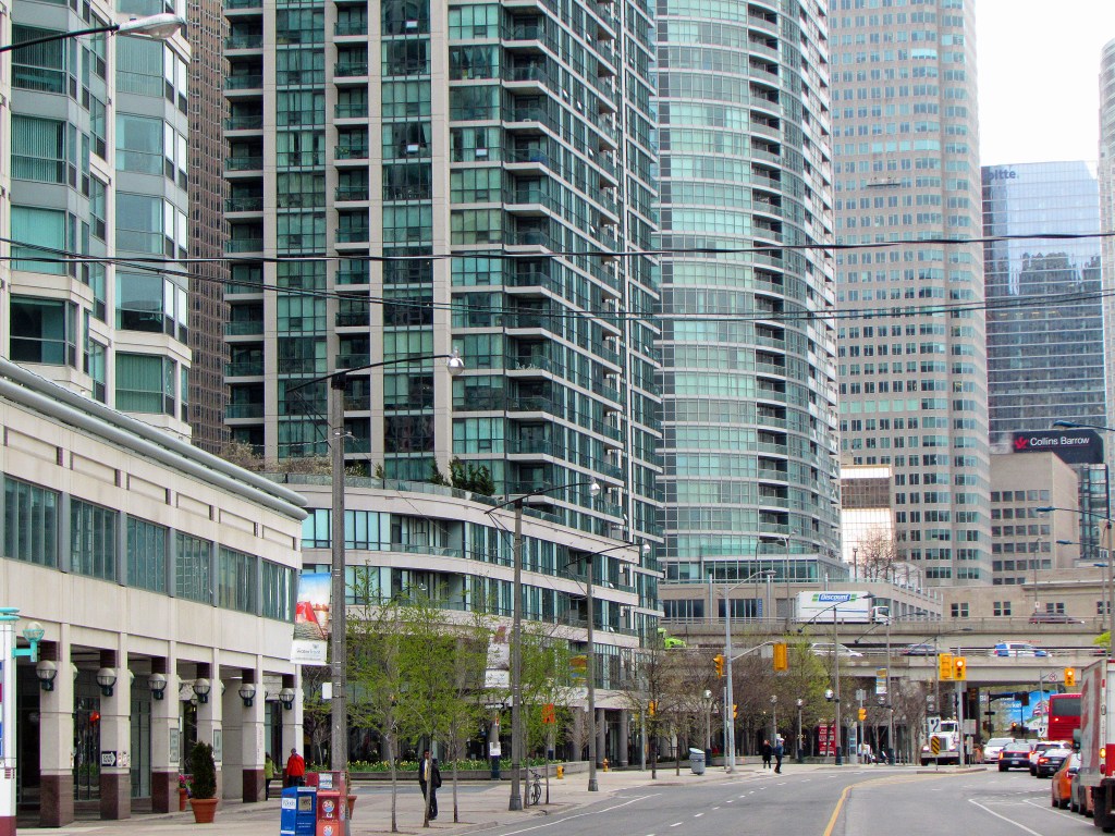
155. Queens Quay and the Waterfront Trail continue east of Yonge, but it’s immediately obvious that this is an area in transition. (Top and middle) To the north, there’s a newly completed skyscraper, the Prestige Condos at Pinnacle One Yonge (2022, 217 metres), currently the 16th tallest skyscraper in Toronto. (Bottom) Just east of it is a huge flattened lot where the HQ and warehouse of the Liquor Control Board of Ontario (LCBO) used to be. Only the northern wall of the old warehouse (still standing in the top photo taken in July 2021) has been retained. Does it strike you that there’s a lot of construction going on in Toronto at the moment? Well, Toronto is currently the most active city in the USA and Canada as far as highrise construction is concerned. Construction activity is measured by counting the number of tower cranes in operation at any given moment. The RLB Crane Index noted that as of August 2023 there were 240 tower cranes active in Toronto, while Seattle, in distant second place, had a mere 45!
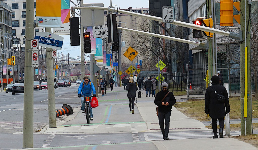
156. Freeland Street is only one block east of Yonge, but already there’s a down-at-heel aspect to Queens Quay E. Let’s leave it temporarily and head south towards the waterfront through a new housing development.
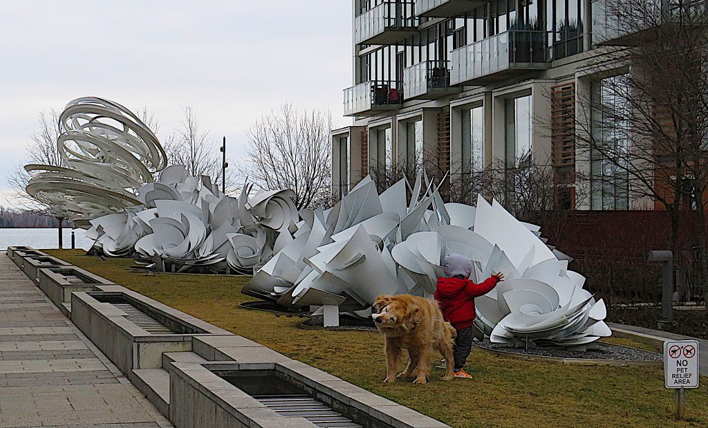

157. This pedestrianized area between two condo buildings is the site of A Series of Whirlpool Field Manoeuvres for Pier 27 by Alice Aycock (USA, b. 1946). “The works increase in size and complexity as you reach the lake. The maelstroms are chaotic, each with hundreds of tranches of conical metal swirls, each trying to form more fully while being buffeted by the next swirl. The fourth work, closest to the lake, is dubbed Toronto Twister, and it takes on a fully cyclonic form, reaching several metres into the air before its last rings dissipate into the sky.” (Courtesy of Urban Toronto). The installation is visually impressive, but as it forms a barrier of sharp metal edges, it’s hardly child-friendly. The tot’s dog seems to be quite happy, though.
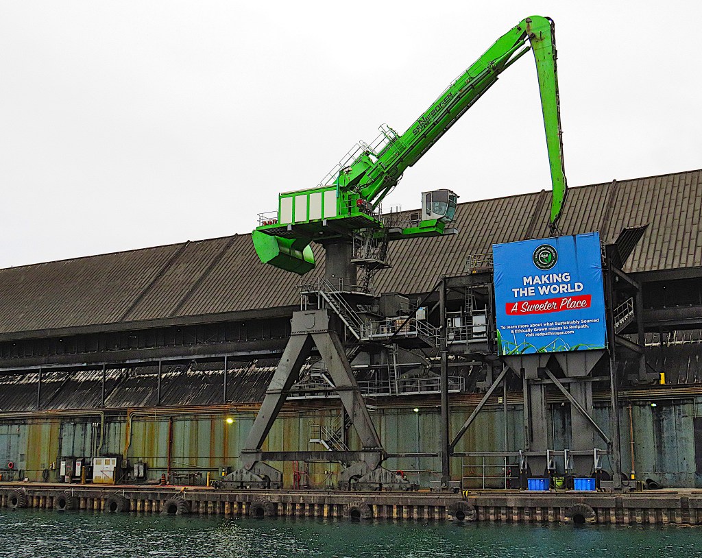
158. The Redpath Sugar Refinery (1958) at Queens Quay E and Jarvis St. is an almost lone survivor from the industrial past of Toronto’s waterfront. The refinery requires a deep water port for importation of raw sugar from from Brazil, Central America, and Mexico. And the proximity of the Gardiner Expressway is convenient, as sugar leaves the refinery on 30,000 truck trips annually, providing 48% of the sugar consumed in Canada. There was a Sugar Museum onsite but it closed down during the pandemic and has not reopened since.
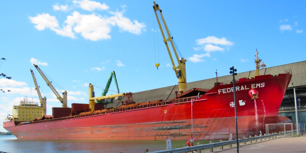
159. The Jarvis Slip by the Redpath Refinery is still a working harbour. The Federal Ems, a bulk carrier built in China (2002) and flying the flag of the Marshall Islands, is here to discharge a load of raw sugar.
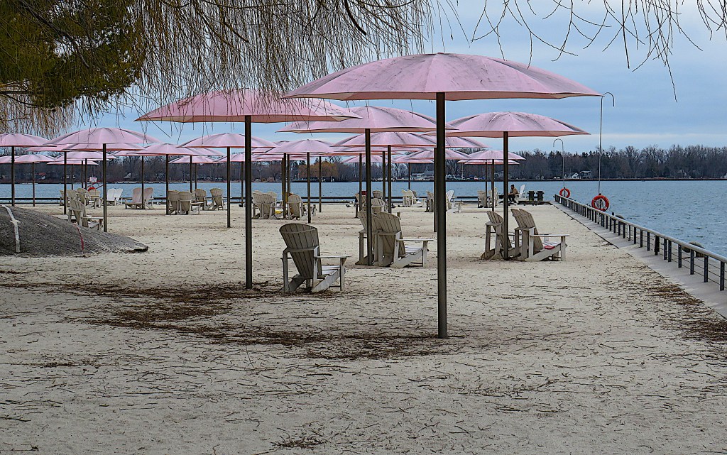
160. A surreal sight on a chilly February day: Canada’s Sugar Beach. This whimsical park sporting Adirondack chairs and pink beach umbrellas occupies the side of the Jarvis Slip across from the Redpath Refinery. And no, you can’t swim here at any time of the year.
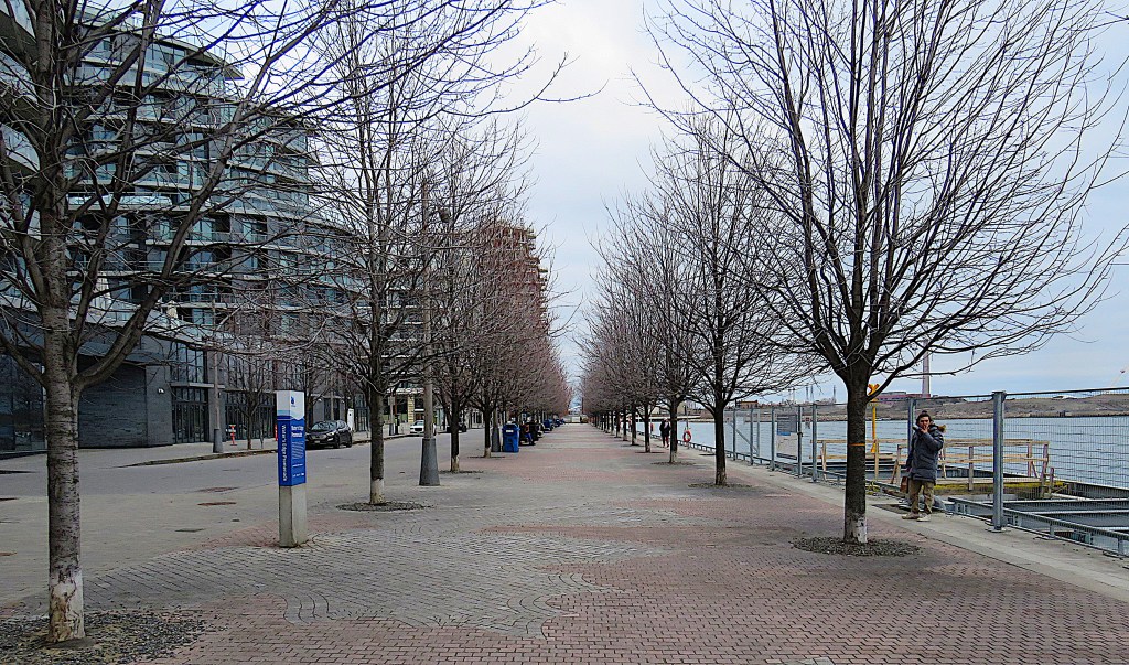
161. This is where Water’s Edge Promenade begins, a newly opened 550 metre pedestrianized avenue running parallel to the lakeshore.
162. This would seem to be one of a series of laser-cut metal signs of climate-focused public art along the waterfront by Canadian interdisciplinary artist Lisa Hirmer (Canada), formerly Waterfront artist-in-residence. But that red ship in the distance …

163. … makes me wonder whether water can really be thought of as a sacrificial victim of humanity, as the quote suggests. Rather, the vessel seems to embody “the invisible labour and violence” that water inflicts on the works of mankind. CSL Tadoussac is a lake freighter launched in 1969. Her hull bears the stigmata of an accident-prone history, that includes several collisions and runnings aground.
164. Here at Knapp Lane is the current end of the Waterfront Trail as a multiuse pathway parallel to Queens Quay. The scene is dominated by the Victory Soy Mills silos, abandoned and derelict since 1991. Up on the right, Aqualuna advertises luxury condominium homes from $2 million, currently under construction behind a hoarding.
165. This is Queens Quay East looking back toward downtown from Merchant’s Quay. There’s very little traffic of any kind, and though we’re only just over 1 km from Yonge Street, the area has an almost post-apocalyptic feel. You’d be brave to invest your $2+ million in a condo here at the moment, though I’m sure the area will be more appealing in a few years.
166. The Waterfront/MGT continues towards Cherry Street on the right of the above image, and we’ll follow it on the next leg of the hike. But today we’ll be turning north under the Gardiner Expressway towards the Distillery District. The underside of the Gardiner is ugly and garbage-strewn, but the raised section does allow relatively easy pedestrian access to and from the waterfront, in contrast to the section at grade in Part 3 of our hike. This dilapidated area will undoubtedly experience rampant development in the near future.
167. Under the Gardiner and a little way up the south end of Parliament Street, and we’re there!

168. This is what the area looked like in 1896 (top) and 1927 (bottom). The top picture (courtesy of Wikipedia) shows how close to the harbour the distillery was, so its produce could be loaded onto ships and sent to all corners of Canada. In the bottom photo, a railway trestle is under construction across the new fill that separates the distillery from the lakeshore. The main east-west rail lines into Union Station and the Gardiner Expressway now occupy most of the reclaimed land.
169. By the later 1860s Gooderham and Worts was producing a quarter of all spirits sold in Canada. A decade later it was probably the largest distillery in the world. But the last whisky here was distilled in 1957 and the whole operation was shut down in 1990. This is the stone distillery building (1859-61) as it is today.
170. Gooderham and Worts was once a household name in Canadian rye whisky. But in 1929 the company was merged with Hiram Walker, the distillers of Canadian Club, and it was later sold to Allied Lyons in 1987, so the brand has not been prominent for years. However, you can still buy of bottles of Gooderham & Worts Canadian four-grain rye whisky at select LCBO stores. (These in the image above are museum pieces.) It’s now distilled in Windsor, Ontario by Hiram Walker, and the brand is owned by Corby Distilleries, an affiliate of the French conglomerate Pernod Ricard.

171. The Distillery District is the largest collection of Victorian industrial buildings in North America and is a National Heritage Site. This is Trinity Street looking south, with lots of red brick on display. Refurbished in 2001 and reopened in 2003, the Distillery District is now one of Toronto’s major tourist attractions, where you can shop, dine, and be entertained in an entirely pedestrianized zone.
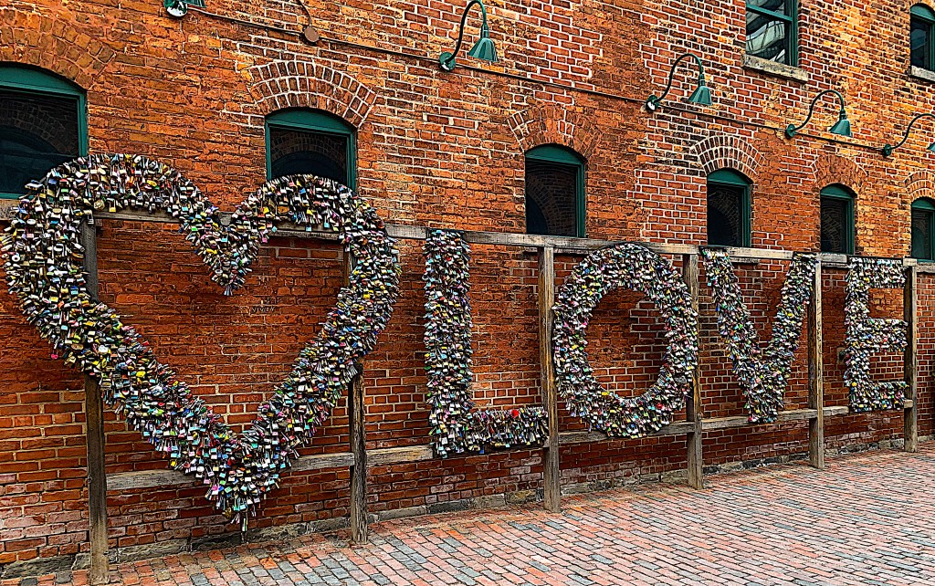
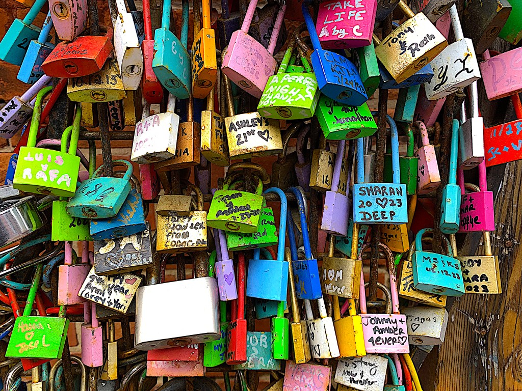
172. Against a wall in Tank House Lane, an assemblage of love locks sends a hopeful message.
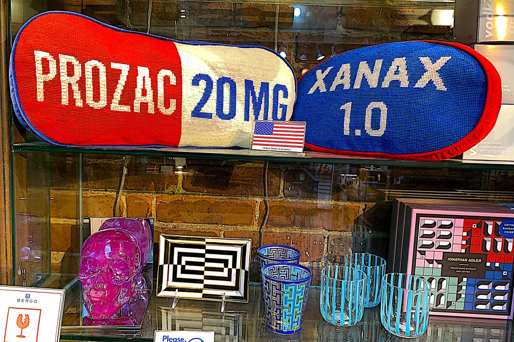
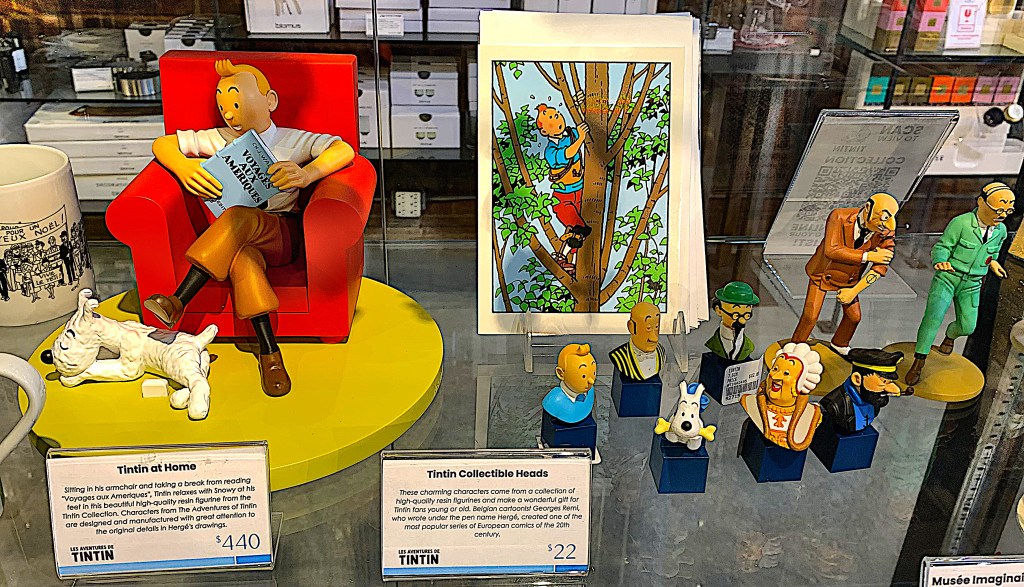
173. There are no chain stores in the Distillery District. Forty independent boutiques sell everything from Prozac pillows to Tintin figurines.
174. And here in Grist Mill Lane is the monster under whose baleful eye we finish this hike. It’s called IT (2009) by Michael Christian (USA), an artist renowned since 1996 for his fantastic creations at the Burning Man Festival in the Nevada desert. IT is constructed from 4.5 tonnes of steel, it’s 12 metres tall, and has a revolving head. Evidently IT’s inspired by the tripodal Martian war machines in H.G. Wells’s classic science-fiction novel The War of the Worlds.
Go to Part 6: From the Distillery District to Tommy Thompson Park
