Bayview Park to the Brant Museum
Date: 13 July 2021
Start Point: Bayview Park, King Road, Burlington
End Point: Joseph Brant Museum, North Shore Boulevard, Burlington
Distance Covered: 5.9 km
Total Distance Covered: 5.9 km

1. I’ll be frank: today’s hike is perhaps the least attractive of all those that follow, so getting it over early is a good reason to start with it. However, it’s not a difficult hike, and it does have several points of interest. But it is on road or sidewalk for just over half its distance. There is a large free parking lot at Bayfront Park at the start of the hike, and a modestly priced pay lot at Waterfront Park at the end. If you have only one car and don’t want to walk both ways, the #4 bus at the end of the hike will take you from Lakeshore and Brock back to near the junction of Plains and King, but that still leaves a 2.5 km uphill walk back to Bayview Park. You may want to call an Uber instead!

2. Bayview Park in Burlington is my recommended start point for this grand loop trail. If you are coming by car, you’ll need to approach from the south, as King Road, once a “mountain access” road connecting Burlington to Waterdown, is now permanently blocked off to traffic at the top of the Escarpment. (More on this later.) There is ample free parking in Bayview Park, and nearby there are information boards that tell you about the history of the site.

Briefly, this was once part of a 3,450 acre lot purchased for 72 pounds 6 shillings and 2 pence on 21 August 1797 by the British Crown from Mississague (sic) tribal chiefs, to become part of Flamborough Township. Much of this lot was prime agricultural land, and the small amount of it that hasn’t been built on still is. In the early 20th century, what is now Bayview Park was turned into a clay pit for use in the manufacture of bricks and sewer pipes. In 1947 the parcel was purchased by the Township and used as a landfill, and continued to be so after it was transferred to Burlington in 1958. When the landfill was closed in 1972, it was covered with topsoil and seeded, to become the current Bayview Park.
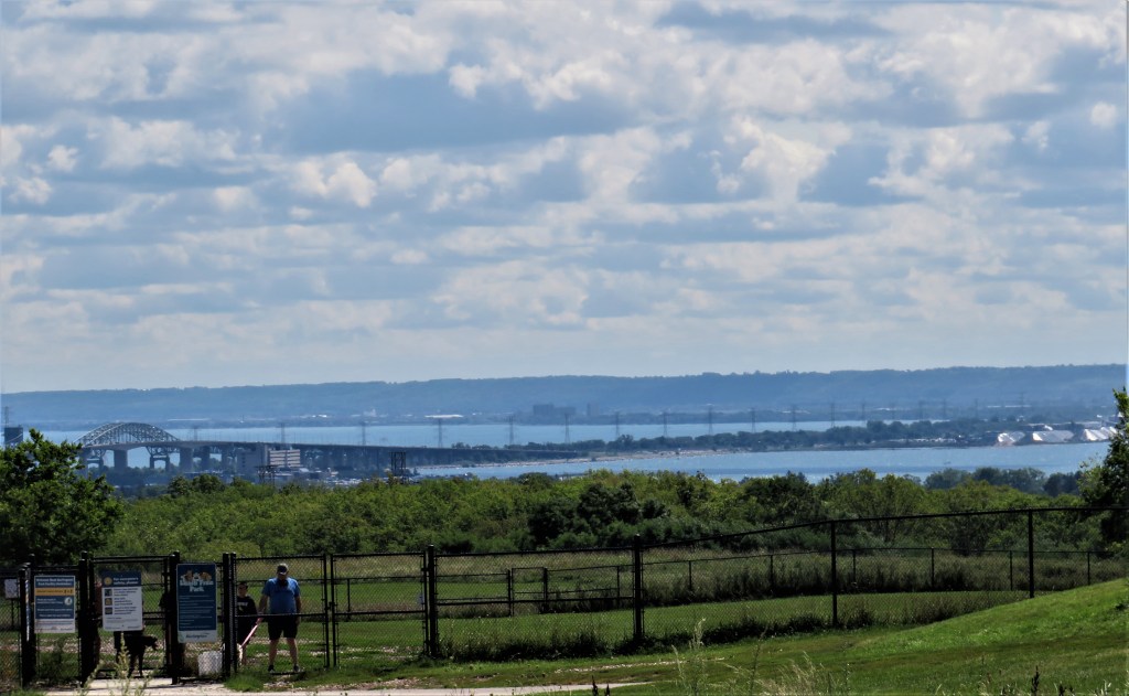
The Park now contains the clubhouse of a radio-controlled model aircraft club, the indoor shooting range of the Burlington Rifle and Revolver Club, and a leash-free dog park. As it isn’t wooded, Bayview Park offers fine views over the Head of the Lake at all times of the year. Above we see the Hamilton section of the Beach Strip dividing Lake Ontario (the upper body of water) from Hamilton Harbour, with the Niagara Escarpment looming over the Stoney Creek/Grimsby area at back.

3. On this old map, oriented with east at the top, the site that is now Bayview Park is ringed in red. Charles King (after whom King Road is named) owned the section immediately to the south, while this site was owned by a J.H. Cooper. “Burlington Bay,” the body of water at right (now called Hamilton Harbour), was so named in 1792 by John Graves Simcoe, first lieutenant governor of Upper Canada, apparently because its location under the Niagara Escarpment reminded him of Bridlington (of which “Burlington” was once a variant spelling), a seaside town in Yorkshire, England that is overshadowed by the cliffs of Flamborough Head. (That’s also how Flamborough Township got its name.) The area south of the Escarpment (the right half of the map), now largely occupied by Burlington suburbia, was known for its fertile soil and contained many market gardens, with melons a particular specialty. Brown’s Wharf (1840-97), projecting into Burlington Bay and connected to the villages of Aldershot and Waterdown by road, was first used to supply timber to Lake Ontario steamers, then to ship building stone, fruit, and other local produce as far east as the Maritime Provinces.

In 1847, the Magnet, a paddle steamer, began a twice-weekly passenger service between Brown’s Wharf and Montreal, via Toronto, Port Hope, Cobourg, and Kingston. In those days, travel by boat was far easier than on dreadful roads, and those who drive east through the GTA on Highway 401 these days might still agree! Brown’s Wharf has now been incorporated into the marina at LaSalle Park.
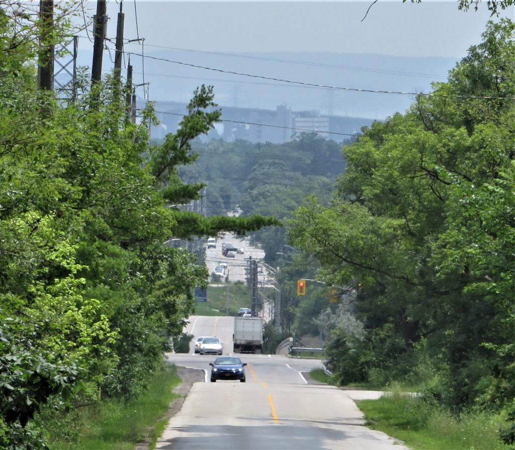
4. This is the view looking south down King Road. There are no sidewalks or shoulders, but there’s little traffic as the road behind us is a dead end. Part of this section of King Road is reputed to be a “magnetic hill” where, because of an optical illusion, cars placed in neutral seem to roll uphill. King Road south from its junction with the North Service Road (at the stoplight) is busier and tricky for pedestrians for about 350 metres. You should cross the Highway 403 bridge on the left side of the road facing oncoming traffic.
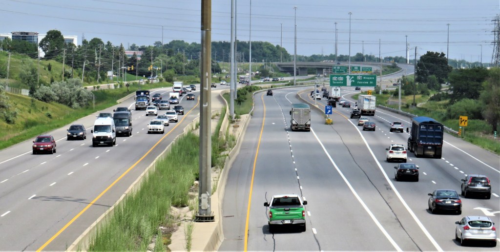
5. This is the view eastward from the King Road bridge over Hwy 403. From left to right: the North Service Road of the 403; three lanes of traffic heading west to Hamilton; the weed-overgrown median; two lanes heading east to the northern suburbs of Toronto via the Highway 407 Express Toll Route; and three lanes heading either east on the north shore of Lake Ontario to downtown Toronto via the Queen Elizabeth Way, or east on the south shore to Niagara Falls via the QEW, with the further choice of exiting locally on Fairview Street in Burlington. In short, this is the most complex highway interchange at the Head of the Lake, and drivers approaching it from the west should watch the overhead signs carefully. A momentary distraction, and they can find themselves on an expensive toll road going to the wrong part of Toronto, or going in the right direction (east) but on the wrong side of Lake Ontario!

6. Visible to the east from the bridge is part of the enormous Hydro One Burlington Transmission Station, an electrical substation taking up a site of almost 30 hectares (equivalent to about 20 city blocks) bounded by both Hwy 403 and the QEW. Giant transmission towers carry power lines in various directions from here, including (as we shall see) along the Beach Strip.

7. Now there’s a proper sidewalk on the left side of King Road as it runs through an light industrial area. CGA Iron Works was a small company making custom-designed wrought iron railings, fences, and balconies. In early April 2020, they stopped forging ironwork and started manufacturing plastic face shields, as well as supplying other Personal Protective Equipment essential in the pandemic, such as masks, sanitizer, disinfectant wipes, and vinyl gloves. At back, the building intriguingly called “The Womb: World of My Baby” is a “wholeness” centre specializing in products and services associated with pregnancy and birth.

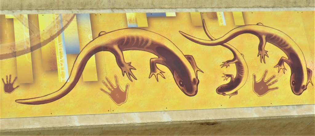
8. King Road crosses the Lakeshore West GO Train tracks via an underpass. The bridge’s parapet is decorated with striking artwork entitled “Escarpment Evolution” (2015) by Judy Mayer-Grieve, one of the winners of a public art competition sponsored by the City of Burlington. Her mural was inspired by the Niagara Escarpment, and the depicted Jefferson salamanders, an endangered species, demonstrate the local commitment to protect the Escarpment’s unique biosphere. Burlington annually closes the upper section of King Road to traffic for four weeks in spring during the salamanders’ mating season, to protect the amphibians’ migration across the road.
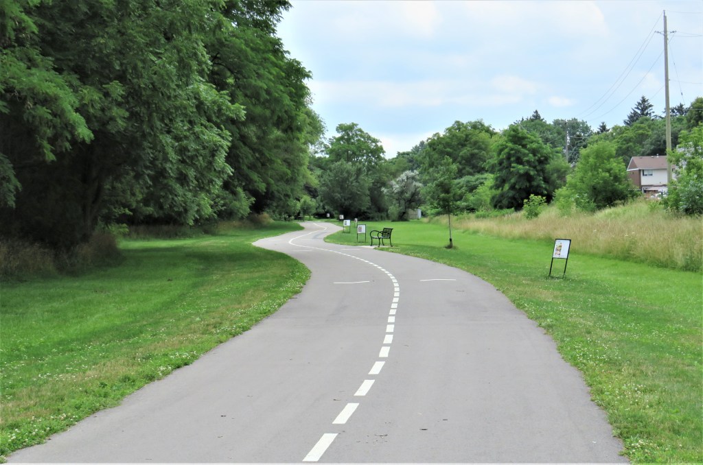
9. Cross busy Plains Road East at the lights, turn left along the south sidewalk, then after one block turn right down Francis Road. The Francis Road Trail is a 1.5 km paved multiuse pathway from here to North Shore Boulevard. We are off road for the first time! The low signs on the right of the Trail narrate a simple illustrated story in seven languages for children to follow.

10. A young Lionel Messi in an Argentina shirt guards a goal by the Trail.

11. A lady takes her whippets for a stroll. This Trail is primarily a cycleway, though not a single cyclist passes me.


12. At North Shore Boulevard, turn left and when it’s safe cross to the south sidewalk. After two blocks you come to a short cul-de-sac, Allview Avenue, that ends with a panoramic view of Hamilton Harbour. A little way down Allview is a magnificent white oak bearing a plaque that designates it an Ontario Heritage Tree. The Ontario Urban Forest Council notes: “[It] is quite possibly one of the oldest and largest Quercus alba specimens in Canada…. This White Oak was a surveyor’s benchmark in 1789 for a treaty arranging the purchase, for the British Crown from the Mississaugue nation, of a block of land that soon afterwards became the 3,450-acre parcel of land known as ‘Brant’s Block’ [see #15 below] …. Until 1957, the tree and survey line defined the border between Aldershot and Burlington.” The tree, probably more than 300 years old, is 30 metres tall and 4.78 metres in circumference.
A note on Ontario Heritage Trees: for a tree to qualify, “it must be associated with a historic person or event, or be growing on historically significant land. The tree’s prominence within the surrounding community and/or use as a landmark is also taken into account; however, it is the historical or cultural significance of the tree that is of most importance.” Anyone can nominate a tree, but landowner’s consent is required if a designation is to be granted. There are currently 99 Ontario Heritage Trees, but only this and one other stand at the Head of the Lake.

13. From the end of well-named Allview Avenue there’s a good view of the Burlington Bay James N. Allan Skyway, the twin bridges (opened 1958 and 1985) carrying the QEW along the Beach Strip and over the Burlington Canal. Known locally as the Burlington Skyway (or just the Skyway), the eight lanes of the 2.5 km long bridges carry on average over 150,000 vehicles per day. The Skyway’s 38 metre clearance enables large ships to pass underneath. You’ll be able to see the enormous structure from multiple perspectives over the course of the loop trail.
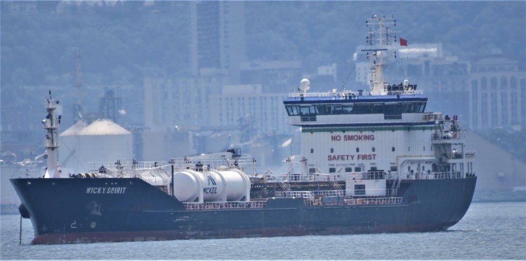
14. The end of Allview is also a good spot to check out what’s afloat or at anchor in Hamilton Harbour, the busiest Canadian port on the Great Lakes. Wicky Spirit (built in 2008 in Istanbul) is a twin-screw, double-hull, ice class oil/chemical tanker (136.77 metres long) capable of handling CPP or DPP (i.e., clean or dirty petroleum products). Owned by McKeil Tankers here in Burlington, the ship’s slightly weird current name is a tribute to Robert Wickens, a Canadian IndyCar driver who was left paraplegic after a crash at Pocono Raceway in 2018.

15. Joseph Brant Hospital, a general hospital named for the great Mohawk military leader and statesman, stands on “Brant’s Block,” i.e., the land granted by the British Crown to Joseph Brant (1742/3-1807; his Mohawk name was Thayendanegea; more of him later) in 1798 to reward him for his loyal service during the American Revolution. The Hospital opened in 1961 and now has 245 beds.
The roads around the hospital have recently been the site of demonstrations by anti-vaxxers. Its management has responded with commendable restraint: “We support everyone’s right to peaceful protest, even when we do not agree on the subject matter; however, recent protests have included harmful messages, harassment and misinformation targeted against our medical and healthcare professionals, resulting in emotional distress and moral injury. This type of protest undermines the hard work and sacrifices of hospital staff, physicians and first responders over the past year and a half and as we head into the fourth wave of this pandemic, driven by the Delta variant. We condemn, in the strongest of terms, this targeted and misdirected abuse and harassment of healthcare workers that has occurred during these recent protests. To protestors: Please take your messages to the decision-makers at City Hall, Queen’s Park and Parliament Hill, and away from our hospitals and the private homes of our community leaders. We also ask you to be considerate of those who need access to our hospital for life-saving treatments and those visiting their loved ones. Healthcare workers do not make policy.”
Having observed one of these demonstrations at this very spot, I’ll add this. As no one is forcing anti-vaxxers to get tested or immunized, their aggressive demonstrations cannot be called “protests.” Rather, their actions are intended to intimidate patients and staff trying to gain access to a hospital that, among its many other life-saving functions, administers Covid tests and vaccinations free of charge to the public. In short, this is obstructive bullying motivated by a desire to raise the level of fear and anxiety in exhausted staff and vulnerable patients. So, let’s call what these “protestors” are doing by its proper name: terrorism.
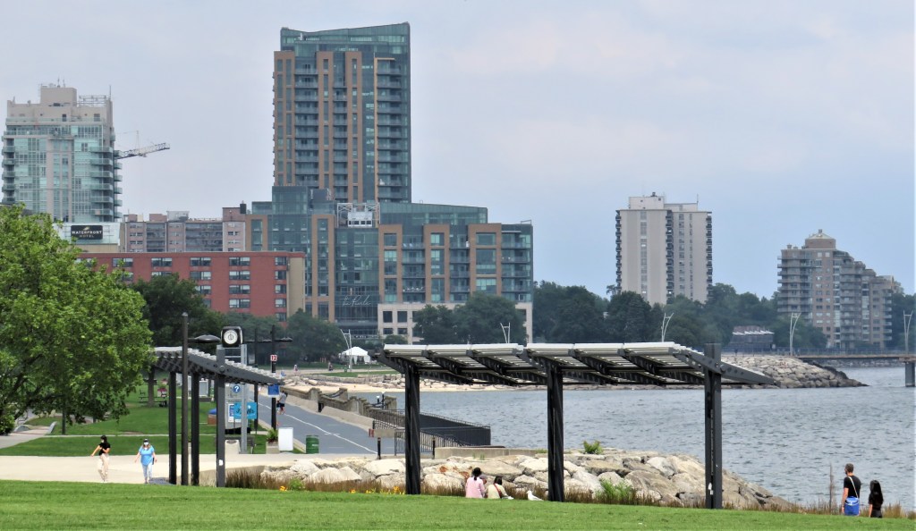
16. Burlington (pop. about 200,000), the twelfth largest municipality in Ontario, has been a city since 1974. Its western suburbs are contiguous with Hamilton’s, and it is increasingly viewed as part of the Greater Toronto and Hamilton Area (GTHA), which is now almost continuously built up for about 150 km along the Lakeshore. Spencer Smith Park, between Burlington’s waterfront and downtown, is an attractively laid-out public area. In 2019, Burlington was ranked by Macleans magazine as the best place to live in Canada … out of 415 communities!
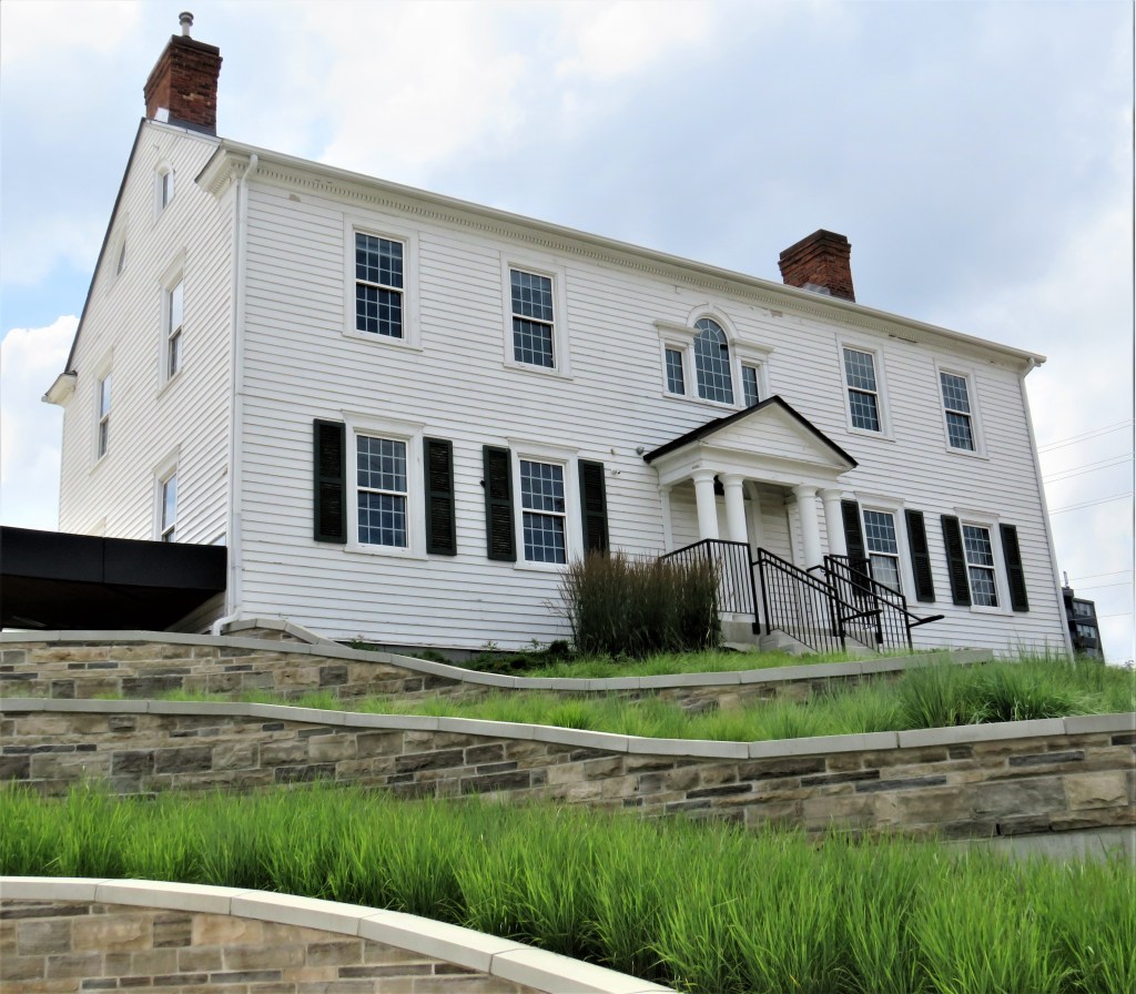
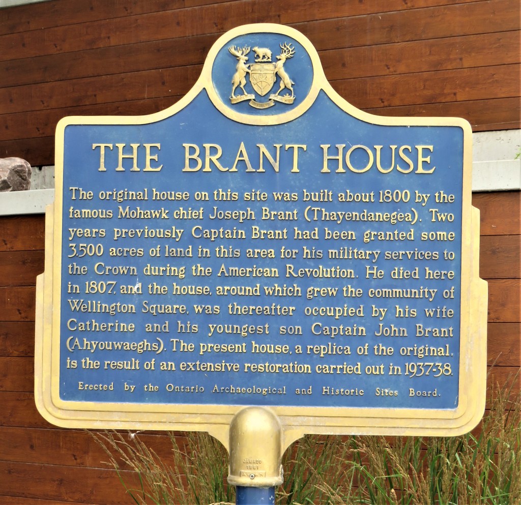
17. A replica of Joseph Brant’s house stands on a knoll in the northwest corner of the hospital grounds overlooking the Burlington Downtown Waterfront. Joseph Brant died in the original house on this spot and is buried in the graveyard of Her Majesty’s Chapel of the Mohawks in Brantford. The origins of present-day Burlington can be found close to this plaque: “Wellington Square” was the name of the first community that grew around Brant’s house, and after it started to absorb other local settlements, the name “Burlington,” after Burlington Bay, came into official use in 1873, though it had been used informally for the area long before that.
Side Trips
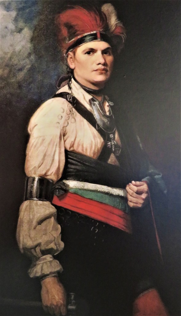
The original is in the National Gallery of Canada.
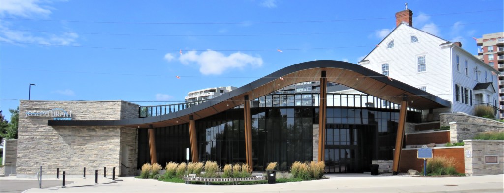
18. As this hike ends at the Joseph Brant Museum, a visit here would seem to be the most convenient side trip. The Museum itself is a sleek modernist structure which, having been expanded and updated, reopened in 2019. In spite of its 1240 North Shore Blvd. East street address, the Museum’s entrance is actually on Lakeshore Road. It isn’t free to enter: the admission fee depends on your age and whether or not there is a special exhibition. The permanent collection, concerning the history of Burlington, is very small and can be viewed in 15 minutes. Perhaps the most interesting items are reproductions of various portraits of Joseph Brant. The replica of Brant’s House that stands above it was not open to the public when I visited. Altogether a little disappointing.
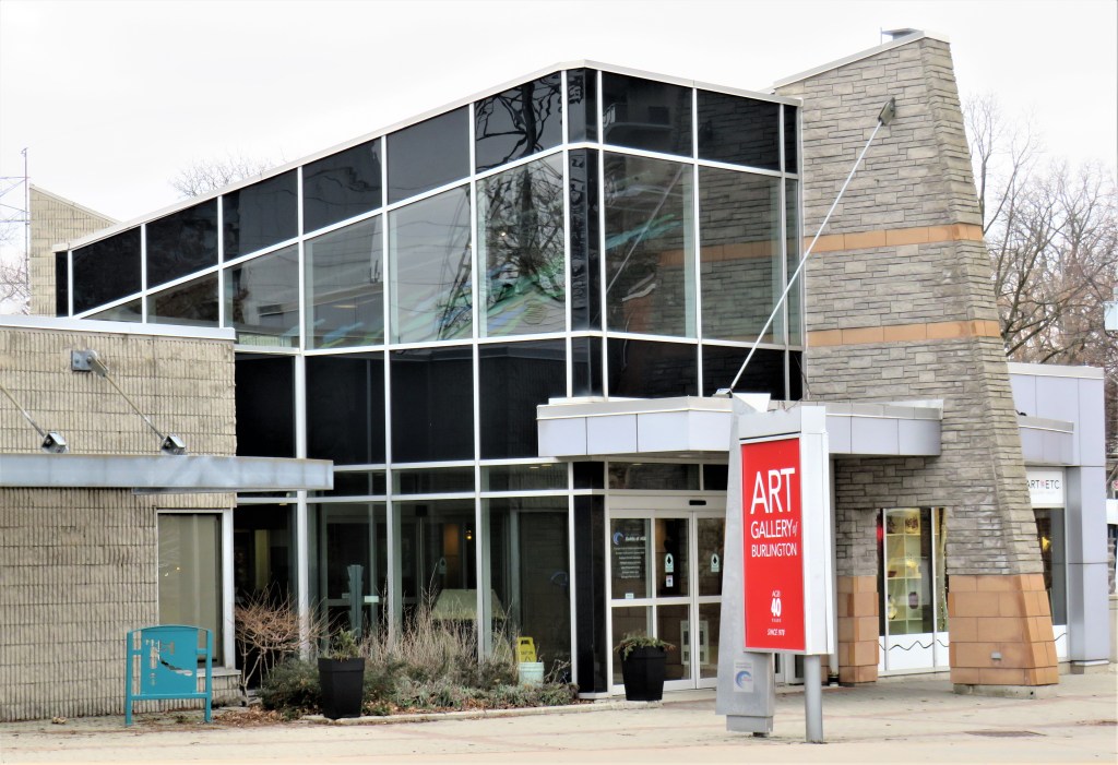

19. Of perhaps more sustained interest is the Art Gallery of Burlington at 1333 Lakeshore Road, a five-minute walk from the Brant Museum. This is a free public gallery and community art and craft centre specializing in contemporary ceramics. If you’re into pottery, you could spend up to an hour here browsing the collection.
