From Davidson Boulevard Side Trail to Livingstone Drive
Date: 23 August 2021
Start Point: Davidson Boulevard Side Trail, Davidson Boulevard, Dundas
End Point: Livingstone Drive at Sydenham Street, Dundas
Distance Covered: 5.1 km*
Total Distance Covered: 55.4 km
*plus ca. 7.0 km via optional return loop.
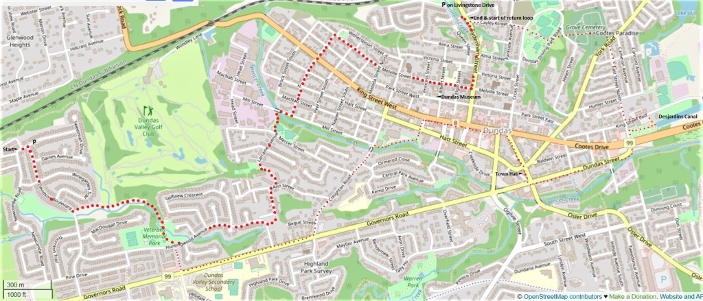
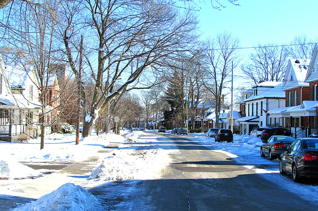
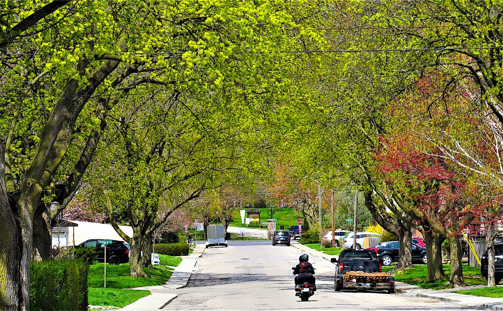
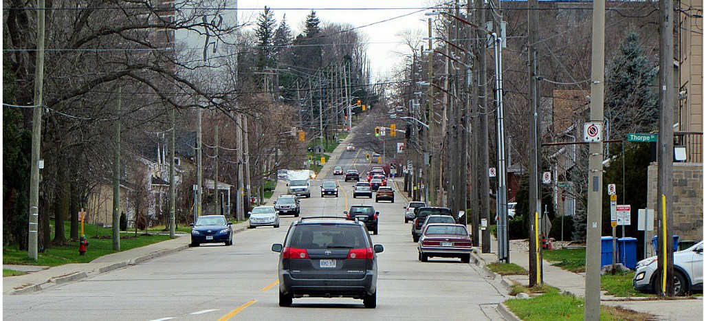
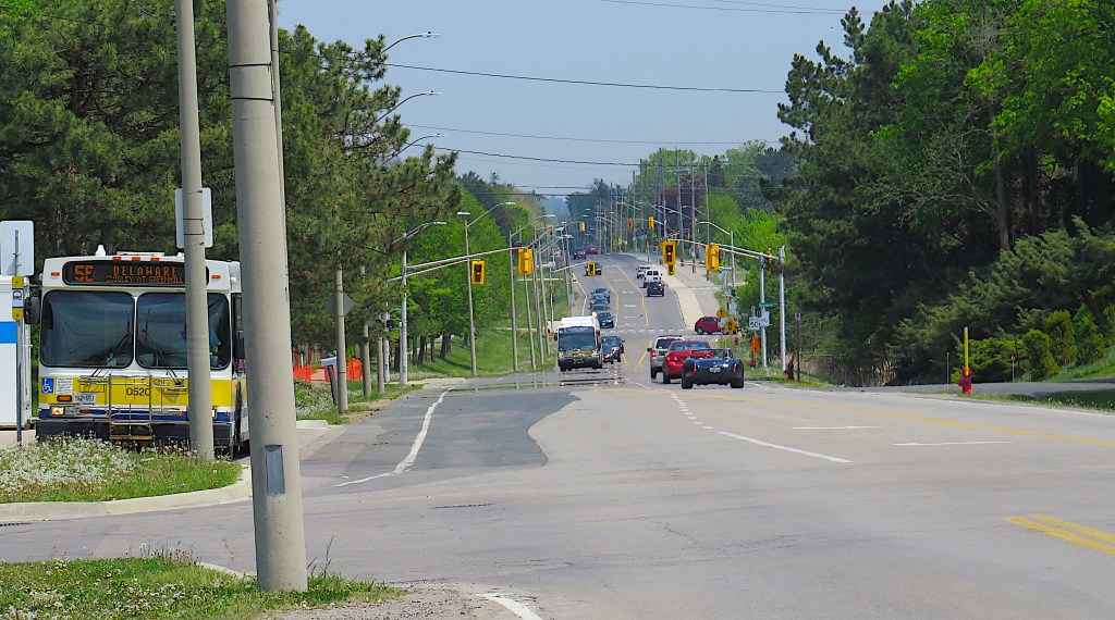
238. Today’s hike is almost entirely urban, along sidewalks with little elevation change, and is doable at any time of the year. If you have two cars, park the start car on Davidson Boulevard as on the previous hike, and the end car on Livingstone Drive by Cascades Park, just off Sydenham Street. Then walk the 5.1 km between these points, following the white blazes of the main Bruce Trail. Note that the first 3.7 km of the hike, between the start and the junction of Wellington and Melville Streets, is a temporary Bruce reroute caused by the reconstruction of Highway 8 (King Street West) where it climbs the Mountain.
Though some distance from Lake Ontario, Dundas (population ca. 25,000) was once considered its Head of Navigation, and remains one of the most historically interesting and visually appealing towns in Ontario. If you have only one car, you can tailor your return to take in some of Dundas’s attractions. My suggested return route (the smaller red dots) covers about 7 km, resulting in a total loop hike of just over 12 km. This may seem a long haul, but there are plenty of places en route, at least in non-lockdown times, to take refreshment breaks.
There are three recommended side trips on this hike. One is to the Dundas Museum and Archives, only one block from both the main and return hike routes. The other two are to the two finest waterfalls in the area and a scenic viewpoint, which will require a car, money to park it, and (if done in tourist season) advance planning.
This hike is relatively accessible via public transit. Take the #52 Dundas bus from downtown Hamilton to its terminus at Governors Road and Pirie Drive and then walk north for 1.2 km along Newcombe Road to the start point. Your return bus stop will depend on where you finish: reasonably regular buses to downtown Hamilton run east along both King Street West and Governors Road. Consult the HSR online for schedules or, if you’re on the street, phone the numbers on the bus stop itself for the next available service.
239. The mandate of the Bruce Trail Conservancy (BTC) is to preserve the Niagara Escarpment as a ribbon of wilderness, so the main Trail’s current detour through Dundas suburbia is hardly ideal. The closed-off section of Trail, past the Valley Golf Course and down Woodley’s Lane, will presumably be restored once reconstruction of Hwy 8 is complete. However, thereafter the Trail shuns the Escarpment for the streets of old Dundas.
Until fairly recently, the Bruce followed Spencer Creek through its spectacular Gorge to the foot of Webster’s Falls and climbed a staircase to its lip. Then it continued along the top edge of the Escarpment to Tews Falls, from where there was a side trail to the Dundas Peak viewpoint.
It’s still just about possible to visit these sites by foot, but access becomes more difficult by the year. The trail through Spencer Gorge has not been maintained, the staircase to Webster’s Falls has disappeared, pedestrian access between Webster’s and Tews Falls has been blocked, and tall fences shepherd visitors from expensive parking lots to the Falls and Peak. So what has happened?
Briefly, this: amalgamated Hamilton started promoting itself as the City of Waterfalls, and Webster’s and Tews Falls were soon overwhelmed with visitors. But both falls have wealthy house owners living in their vicinity who were not happy with what they considered invasions of their privacy by riff-raff. Of course, Hamilton Conservation Authority (HCA), that administers both falls, should never have allowed private dwellings to proliferate near sites that should be accessible to all. (Contrast the Niagara Parks Commission’s role in preserving universal accessibility to Niagara Falls.) But it did, and has so far surrendered to the will of these residents. The result is that in tourist season, visits to Webster’s and Tews Falls are car dependent, strictly controlled, and expensive. The BTC doesn’t have the means to intervene in this standoff, so the main Bruce avoids Spencer Gorge, its two waterfalls, and the Peak altogether.
You, however, shouldn’t have to miss out on the leading natural attractions at the Head of the Lake. There are suggestions about when best to visit these sites in #263 below.
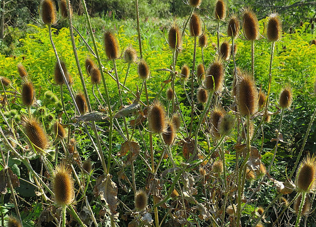
240. A common sight on waste ground in the Dundas area are teasels (Dipsacus sylvestris), prickly plants similar in appearance to thistles but actually unrelated to them. Teasels are now considered an invasive weed in Ontario, but they were once imported deliberately from the Old World as they had an important industrial use: raising the nap on wool and other fabrics. Dundas has a long history of textile manufacture, so undoubtedly teasels were used here from the early 19th century on.
Teasels’ similarity to thistles may have led to the convergence of sound in their names, which are etymologically unrelated. Teasel comes from Old English tǽsel, connected with the verb to tease, as “teasing” wool is the technical name for their industrial use. Thistle, on the other hand, comes from Old English þistil, which may possibly be derived from a Proto-Indo-European root meaning to pierce.
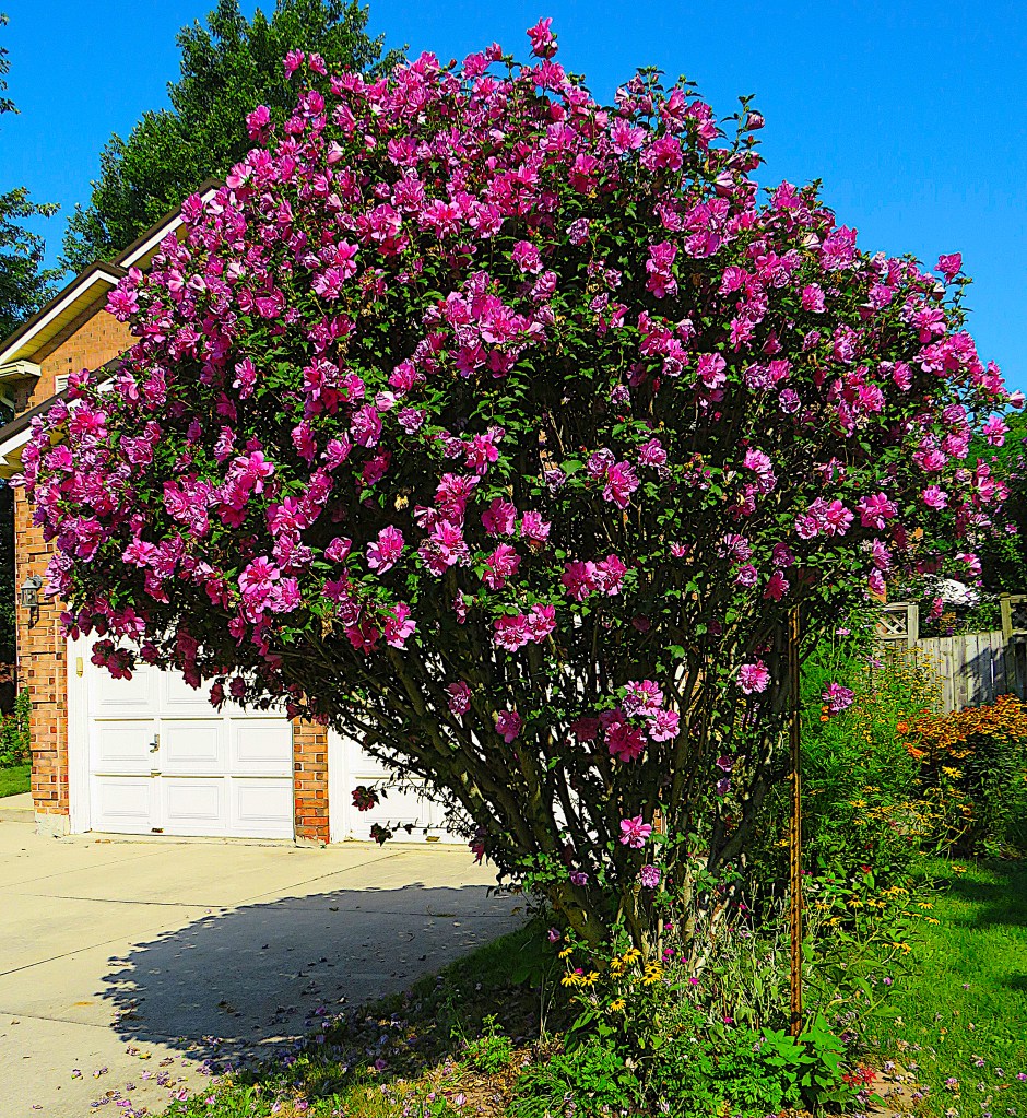
241. A popular shrub in suburban Dundas is Hibiscus syriacus, which means “hibiscus from Syria.” Its actual origin is likely to have been farther east. It’s the national flower of South Korea, where it’s known as mugunghwa. In North America, it has the beautiful, biblical name “rose of Sharon.” It’s quite hardy, and though individual blooms are very short-lived, the shrub as a whole can blossom for weeks. It loves full sun, which it gets here in this newish suburb where there are few fully grown shade trees.
“Rose of Sharon” comes from the Song of Solomon (2:1), a chapter of the Old Testament that’s essentially an erotic poem. This chapter was admitted to the biblical canon only because it was supposedly written by King Solomon and must therefore have been inspired by spiritual rather than carnal thoughts!
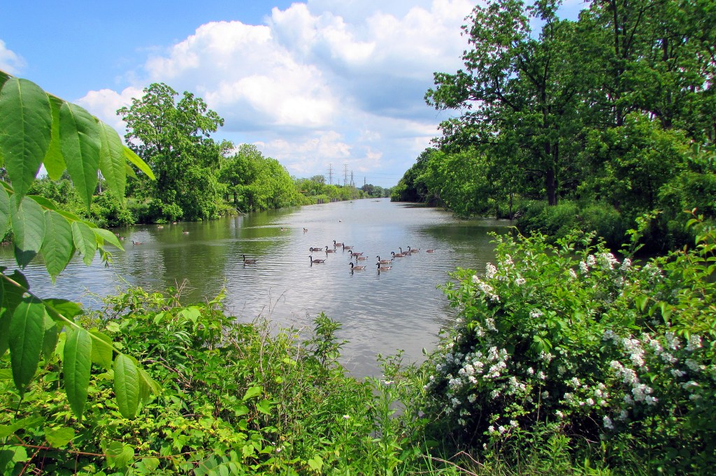
242. Where the trail meets the bridge on Mill Street, you make your first acquaintance with Spencer Creek. This waterway is Dundas’s raison d’être, as its energetic course from West Flamborough through Crooks Hollow, over the Escarpment at Webster’s Falls, down into the Valley, and on into Cootes Paradise made Dundas an obvious place to build water-powered mills in the days before steam. Spencer Creek isn’t big enough to be called a river, but it’s certainly the liveliest creek at the Head of the Lake. And it’s now technically the Head of Navigation of Lake Ontario, as when it’s running high, you can paddle a canoe (though nothing larger) from Dundas into Cootes Paradise, portage it around a fishway, and continue through the Desjardins Cut into Hamilton Harbour and thence into the main lake.
243. “Stone buildings,” notes Nina Perkins Chapple, “hold a special attraction, a fascination with their ageless quality, strength, and endurance, and with the natural beauty of the stone itself” (A Heritage of Stone, 2006), p. 9. There are about three dozen stone houses in Dundas. Most date from 1850-60, and quite a few are small cottages like this recently renovated one on Wellington Street North. Raise the Hammer, a Hamilton urbanist collective, offers an online annotated tour of some of Dundas’s finest stone buildings, including details of the origin and composition of the stone.
244. Just before you turn right on Melville Street, pause to admire this beauty on public display. It’s a 1941 Plymouth Special Deluxe Sedan with “suicide” (i.e., rear-hinged) passenger doors.
245. Melville Street runs two blocks north of King Street West, Dundas’s main drag. In summer, its chief attractions are its setting, its varied domestic architecture, and its front gardens. This is 189 Melville, framed by the forested height of the Escarpment just east of Dundas Peak.
246. This is one of the HOLO hikes that can easily be undertaken in colder seasons. The residential section of the old town here at the curve of Melville Street is as attractive under snow as it is under spring blossom or fall foliage.
The streets that cross Melville here commemorate worthies (or rogues, if you prefer) of the British Empire: Wellington, Peel, Napier. So, who was Melville? Probably none other than Lt.-Gov. Simcoe’s old friend Henry Dundas, ennobled as 1st Viscount Melville in 1802.
Historians cannot agree about whether Henry’s deliberate delaying of abolitionist legislation was utterly reprehensible or a masterstoke of timing that ensured subsequent passage of the bill. But there is little doubt that he had no interest in Canada, while his role as “absolute dictator of Scotland” was hardly a model for a modern democracy: he had “the means of rewarding submission, and of suppressing opposition, beyond what was ever exercised in modern times by any one person in any portion of the empire”: so Lord Cockburn, quoted in Henry Scadding, Yonge Street and Dundas Street: The Men after Whom They Were Named (1878), p. 15. And then there were the accusations of financial malpractice in the Navy that led to Henry’s resignation as First Lord of the Admiralty and banishment from the Privy Council. Was his tarnished reputation solely the result of an anti-Scottish, anti-Tory conspiracy? Smoke is rarely found without fire.
Whatever the case, Toronto plans to rename its Dundas Street in 2022. The town of Dundas was ahead of the game: its Dundas Street became “Governors Road” ages ago. This way of memorializing Simcoe, whose importance in the shaping of Upper Canada is inarguable, would surely work in Toronto too.
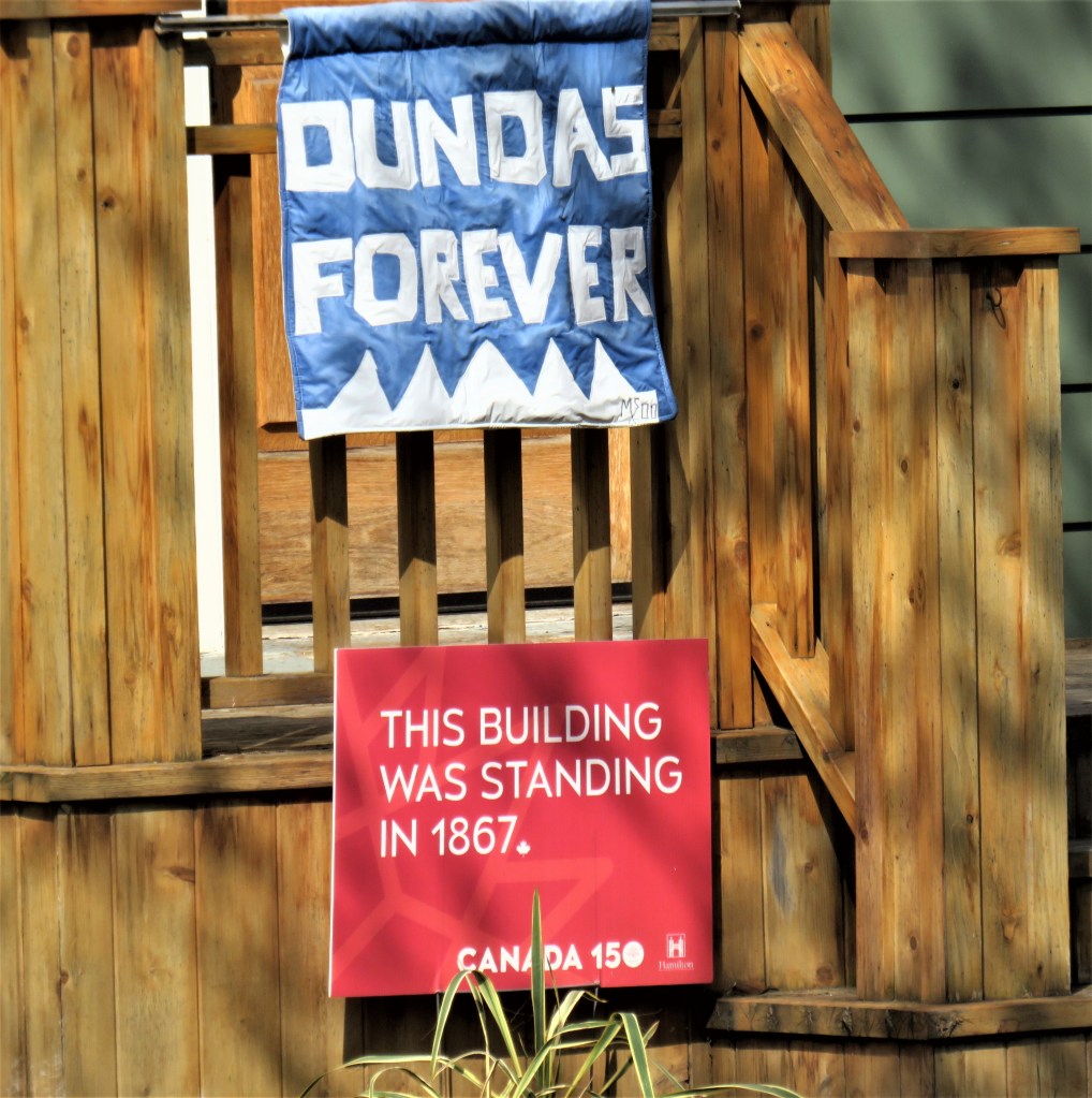
But what should be done with the Dundas/Melville associations in Dundas itself? I’d venture to propose: a little but not much. Most Dundas residents until recently had no idea who Henry was. And despite his revived notoriety, the town’s name continues to have very positive connotations for its inhabitants (left). Dundasians pride themselves on the uniqueness of the town’s topography, its long history, and its independent, even radical, spirit reaching back to arch-rebel William Lyon Mackenzie. They were almost unanimously opposed to amalgamation with Hamilton. (Even though Dundas is now technically a Hamilton suburb, this separatist sentiment will continue until Hamilton becomes the kind of a city that inspires pride in all its citizens.) Moreover, Dundas was not named for Henry, but for a street and a mill. Most Ontarians will continue to assume that their local Dundas Streets are named, not for Henry, but because they end up in Dundas. (This is true of Governors Road and Hwy 8, but not of Toronto’s Dundas Street.) So Dundas should keep its name. (In the unlikely event that there is a sudden revulsion against it, then “Cootes Paradise” isn’t a bad alternative.)
Furthermore, I’d suggest that historical information should be made widely available in Dundas, explaining the tangled history behind the town’s name. If such raised consciousness leads to the education of local schoolchildren in the importance of the abolitionist movement, so much the better. As for Melville Street: the section west of the curve above was called “Mountain Street” until 1914; let residents decide if they want to bring back this name for the whole street.
Side Trip 1: Dundas Museum and Archives
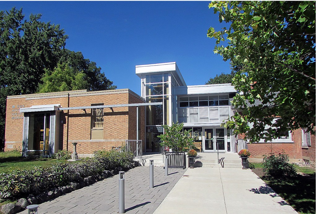
247. Dundas Museum and Archives is at 139 Park Street West between Albert and Princess (see the map above). It’s only one block from either your route out along Melville Street, or your return along King Street West. Entry is free (though donations are welcome); check its website for opening times. The purpose-built museum (1956), now expanded into the older house next door, contains fascinating displays on the topography and history of Dundas, and offers the occasional special exhibition on subjects of local interest. There’s a small gift shop. A couple of giant machine tools stand guard outside the front entrance, attesting to Dundas’s now almost vanished heavy-industrial heritage. Dundas’s 1848 doctor’s office with original furnishings (tours on request) is on the Albert Street side of the site. The museum also holds the extensive archives of the former Town of Dundas (1847-2000), a treasure trove for local historians. Quite a few photographic holdings are available to view online.
Returning to the Main Hike …
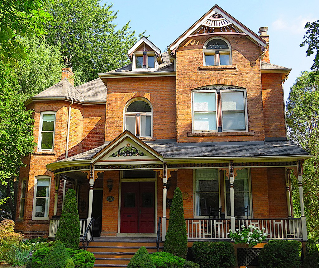
248. “Lawnside” (ca. 1892) at 113 Melville Street is a fine example of the late Victorian brick villa. It was built for the family of Harry Lennard, whose daughter Winnie was born in the house and occupied it until she turned one hundred years old.
The Lennard family was prominent locally. Harry’s brother Samuel (who lived next door at “Roselawn”), born in Leicester, England, was the head of one of Canada’s most successful hosiery manufacturing firms. The Lennard factory (now demolished) on King Street West at John Street worked in collaboration with the Dundas Cotton Mill to produce a wide variety of knitwear from cotton, wool, (and later) nylon and rayon until 1973.
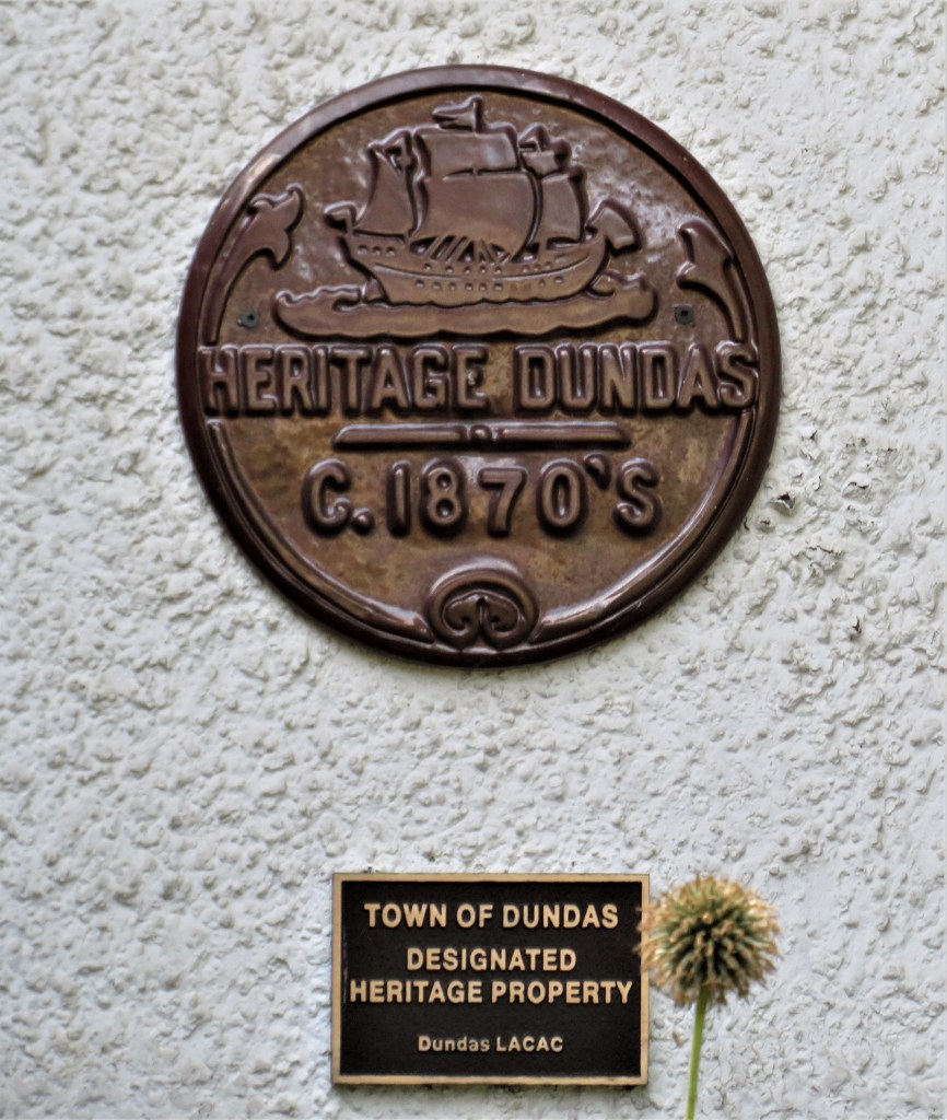
249. A walk along Melville Street through old Dundas is a reminder that this charming urban landscape has been formed over almost two centuries, and will always be vulnerable to the whims of individual property owners or the greed of developers. So these plaques are important: who would have guessed at the age of this little cottage at 60 Melville?
And while we’re on the subject of heritage, it’s timely to recall that Canada is the only developed country that has no federal heritage legislation. More specifically, while Canada signed the 1976 UNESCO Treaty committing it to preserve its built heritage, “inexplicably, we remain the only G7 member whose national statute neither protects the structures nor supports their reuse.” Further, “Canada … actually incentivizes destruction of built-heritage assets through a tax system biased toward demolition, and a government leasing policy that largely disqualifies heritage buildings on the theory that they are awkward to lay out in cubicles for bureaucrats.” For more details, see Policy Options (18 August 2021).
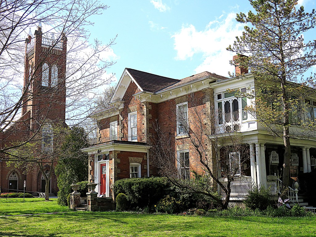
250. The scene at the corner of Melville and Sydenham Streets. In the background is St. Augustine’s Roman Catholic Church (1863), the largest church in Dundas, whose tower (added 1885) is a landmark that can be seen for miles, as it stands above the canopy of trees that cover the old town. In the foreground is “Melville Lawn” (ca. 1876) at 45 Melville Street. This fine Italianate brick villa was built for J.S. Grafton, a scion of another notable Dundas family involved in the manufacture and retailing of clothing until 1976. Their department store, Grafton and Company, dominated both sides of King Street West in Dundas in the later 19th century, and had branches throughout southern Ontario.
Turning left off Melville, walk three blocks north up Sydenham Street, then turn left on Livingstone Drive, bearing right when the road forks. Your end car is parked in front of Cascades Park.
But if you are continuing …
Return Loop

251. … turn right on Cayley Street before you get to Livingstone. Follow this street (which has no sidewalks) down the hill. A short footpath at the dead end takes you down into Dundas Driving Park.
The Driving Park today is the kind of community recreational space that other municipalities can only dream about. A flat area flanked by the Escarpment on one side and a postglacial mound on the other, it boasts attractions that, to judge by the crowds on a fine day, have yet to go out of fashion. Aside from the immaculate bowling green, which has been in use for at least a hundred years, there are play structures, four baseball diamonds, basketball practice hoops, tennis courts, a wading pool that turns into a winter skating rink, a spray pad, a bandshell/concession, a beautiful rock garden, a magnificent oak tree, various sculptures, plenty of picnic tables and barbecue pits, and pavilions and kitchenettes for rental. Extended families come from miles around to have outdoor get-togethers here, a practice that the pandemic has only encouraged.
The circular road around the Driving Park is a reminder that this park began as a harness racing track (hence the “Driving”) in 1834. The Town bought it in 1886 with the idea of renaming it Dundas Park, but “Driving” has stuck. That’s possibly because it is car-friendly, with a circuit you can drive (slowly) around, and plenty of free parking spaces.
On the opposite side of the park to the point where you entered, there’s a tall wooden staircase. Climb it …
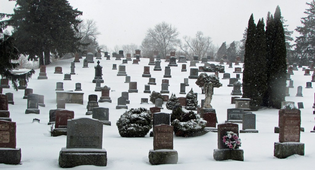
252. … and at the top enter Grove Cemetery through a back gate.
Grove (established 1852; its street address is 129½ York Road) is Dundas’s most atmospheric burial place. It covers the top and flank of a steep mound, and from its highest point there is a fine view towards Hamilton that includes both sides of the Dundas Valley. Grove contains the graves of many local worthies, including members of the Lennard and Grafton families (see #248 & #250 above). The cemetery is still active, though not too many spaces remain.
Take either of the roads that lead steeply downhill, because they both end at the main entrance on York Road, which is where you leave the cemetery.
253. East Street North looking north toward the main entrance of Grove Cemetery. This well-treed street is the extension of the East Street that bounded the original townsite of Cootes Paradise in the surveyor’s map of 1801.
Descend East Street toward the camera, then turn left on King Street East …

254. A Canadair CT-133 Silver Star jet trainer is mounted in the parking lot of the Hamilton Air Force Association HQ. This type of plane, the Canadian version of the Lockheed T-33, had a maximum speed of 920 km/h and was in service from the 1950s to 2005. This particular one was built in March 1959.
Cut across diagonally across the parking lot, heading for those trees …
255. … and in summer you’ll find yourself on the overgrown pathways of the Urquhart Butterfly Garden (free admission). This is a small garden between Centennial Park and the end of the former Desjardins Canal that’s devoted to plants that attract butterflies. It’s named for Dr. Frederick and Norah Urquhart, University of Toronto entomologists who in 1975 established the remarkable facts of monarch butterfly migration. They had recruited hundreds of volunteers to tag individual butterflies in Ontario, learning, among other things, that monarchs could travel 130 km per day, but never flew by night or over water. Two of their volunteers subsequently found one of the secluded mountainous locations in Mexico, 4,000 km from Ontario, where eastern monarchs overwintered. This garden was the brainchild of local activist Joanna Chapman, and the Urquharts considered it the most lasting tribute to their work.
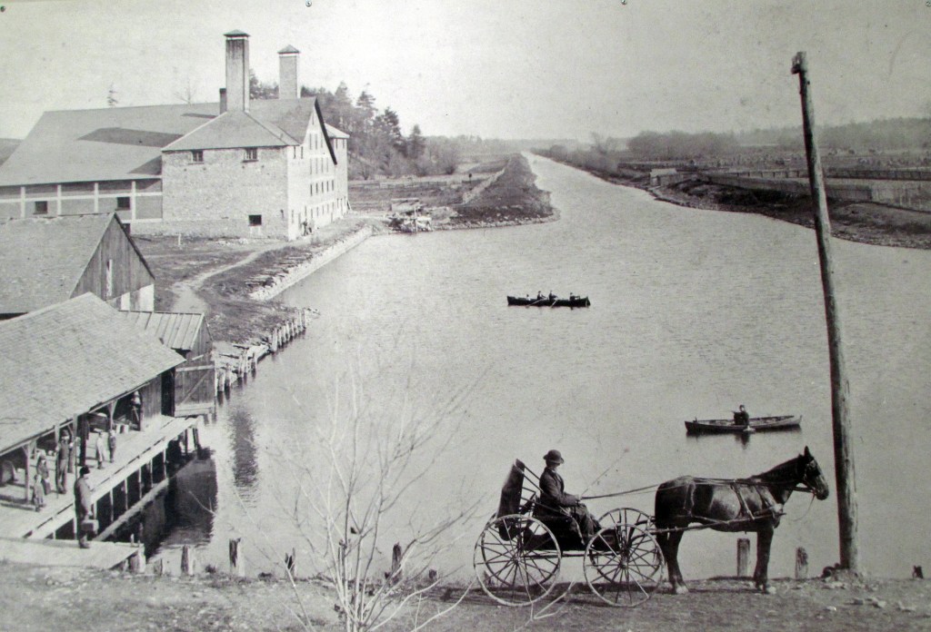
256. (Top) This is the end of the Desjardins Canal, the waterway that accounted for the prosperity of Dundas in the first half of the 19th century. The Canal was conceived by Pierre Desjardins, a French immigrant to Upper Canada. He believed that Dundas, already well-positioned at the hub of Upper Canada’s road network, could be made the effective Head of Navigation of Lake Ontario. This would involve dredging a canal through shallow Cootes Paradise, so that larger vessels could ply between Dundas and Lake Ontario. No locks would be needed, as there was no significant elevation change.
Desjardins died of an unknown cause in 1827, but his canal project outlived him, and was finished in 1837. Dundas experienced a boom as a result of the canal, but it was short-lived. Thanks to the already-completed Burlington Canal of 1826, Hamilton on Burlington Bay established itself as the more accessible Head of the Lake. The railroad age, which began in 1836, reduced Dundas’s advantage as a road hub. The requirement to constantly dredge the marsh further damaged the Desjardins Canal’s prospects. By 1877 the Desjardins Canal Company had been wound up, and Dundas had lost the race to dominate shipping at the Head of the Lake. It was fated to remain a small town, while Hamilton grew to be a big city.
(Bottom) An original photograph of the Canal’s turning basin at the Dundas end, once lined with warehouses. In 1967 this basin was filled in to create Centennial Park (and later the Urquhart Garden). Discrete stretches of the Canal, popular with waterfowl and anglers, remain at its western end. Its former course through Cootes Paradise can still be detected when water is low.
Return to East Street and cross Cootes Drive at the lights.
257. This is Dundas Street, Dundas, looking west. You’re at the end of Upper Canada’s original Dundas Street as it ran through the village of Cootes Paradise.
Go up here as far as the first traffic lights at Main Street, where Dundas Street changes its name to Governors Road.
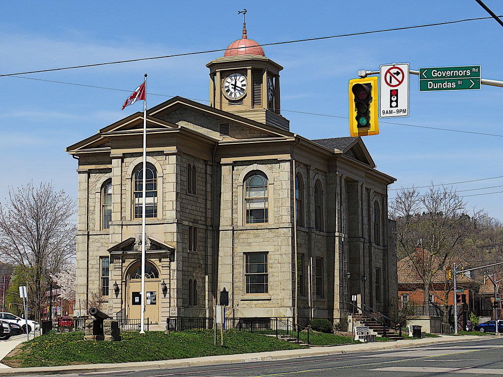
258. Close to the junction stands Dundas’s former town hall. Dundas was incorporated as a town in 1847, and to celebrate, construction of this building was begun in 1848, to be completed the next year. In Classical Revival style, it was designed and built from sandstone by local men at a cost of £2,500. It’s been called the finest surviving pre-Confederation municipal building in Ontario. In its early days, its basement contained market stalls, a saloon, and the town jail. Today, Dundas is administered from Hamilton City Hall and this building is a “municipal service centre”* at street level. In actuality it’s sadly underused during normal times and completely closed during the pandemic.
*Where you get marriage licenses and transit passes, and pay property taxes and parking tickets if you have no internet access.
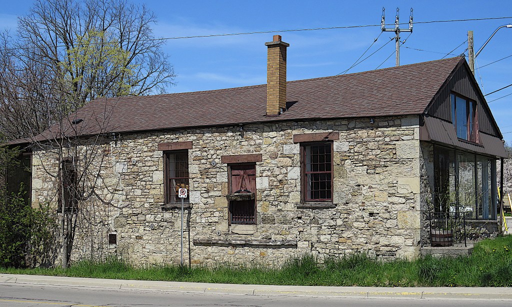
259. Just south of the Town Hall is this aged stone building, whose roof is bowed and whose south wall visibly bulges out over the sidewalk. Its street address is 2 Hatt Street, and its location where Hatt Street, Main Street, and Governors Road converge has been referred to as the hub of Upper Canada. It’s the oldest building still standing in Dundas, built ca. 1804 as an office, smithy, and general store at adjacent Dundas Mills, the grist mill built by Richard Hatt. Hatt’s mill on Spencer Creek near the start of Simcoe’s military road was where Dundas began and gave the town its name. (Demolished in 1968, the mill occupied the site where the Dundas Valley Metro supermarket now stands.)
It’s believed that this building was used as a temporary barracks during the War of 1812. Legend has it that Major-General Isaac Brock, instrumental in foiling the American invasion that year, stayed in it en route to Detroit, or to Queenston Heights, or both. It later became the first post office in Dundas. From 1961 it was a lighting store, during which time sections of stone wall were removed and display windows awkwardly fitted. In short, this little building, one of the most historic in Ontario, has been shamefully treated over the years and is entirely unprotected by heritage legislation. It’s currently vacant, probably in the hope that its fate will be demolition by neglect so its site can be sold.
From here, go north up Main Street and turn left at King Street West.
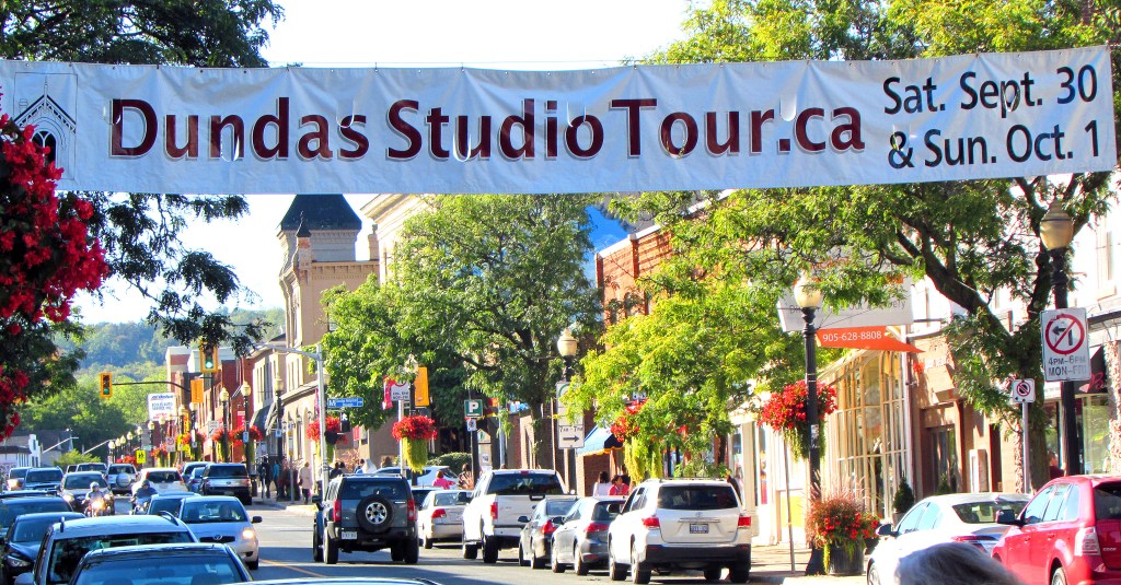
260. Downtown Dundas – the “Business District,” as the signs on Highway 403 pompously put it – is the roughly 1 km stretch of King Street between its junctions with York Road in the east and Market Street in the west. It features a lively mixture of independent stores and eateries that has so far not degenerated into tourist trappery and is just about surviving the winnowing of the pandemic. The Studio Tour banner refers to a (pre-Covid) annual event in which the homes of local artists and craftspeople are opened to the public as pop-up galleries.
Turn left down John Street, cross Hatt Street, walk alongside Spencer Creek through the parking lot of the Grightmire Hockey Arena/Centre for the Arts/Community Pool, turn left at Market Street and continue along it as it becomes Creighton Road. When this meets Governors Road, turn right.
261. Governors Road at Pirie Drive, looking east towards Dundas, the bus terminus at left. It’s just over 1 km north of here to your start car on Davidson Boulevard. If you’re using transit, the bus takes about 30 minutes to get from here to downtown Hamilton.
Side Trip 2: Webster’s Falls
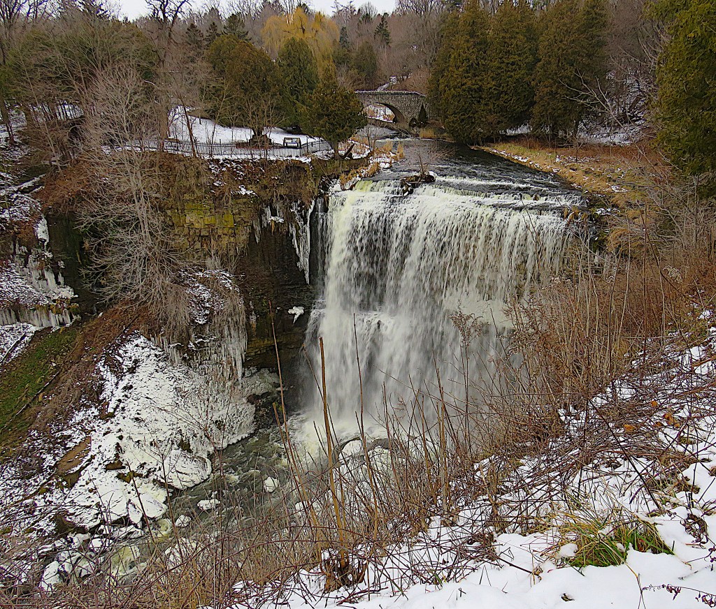
262. Webster’s Falls is a 22 metre plunge waterfall where Spencer Creek runs over the edge of the Niagara Escarpment. A mini-Niagara, It’s an awesome sight at most times of the year. The view above is the classic one that greets you as you walk the short distance from the P to the overlook. You can get closer to the lip by taking the path that leads across that attractive stone bridge. Because most tourists visit Webster’s on weekends between May and October, it is best to avoid those times. Besides, the falls is most impressive when a lot of water is going over it: during spring runoff of course, but also on mild days in winter when local snow is melting. That’s when the picture above was taken; on a January weekday afternoon you’ll probably have Webster’s entirely to yourself.
Because of the issues discussed in #239 above, don’t expect much local assistance in finding Webster’s Falls; signage is currently in short supply. To get there from Dundas by car, take the Sydenham Road Mountain access and turn left at Harvest Road. After 3 km, turn left again along narrow Short Road, and follow it almost to the end. There’s a fairly large P where you’ll have to pay unless you display a HCA membership card.
Webster’s Falls is named for Joseph Webster, who purchased the falls in 1819. Mills were subsequently constructed in the area round it to exploit its water power, the last of which burned down in 1898. A hydroelectric plant was built in 1899, though it too burned down two years later. Webster’s Falls and surrounding area was bequeathed to the public in 1931 and landscaped in 1933, when the stone bridge was built. Since 2000 the site has been under the auspices of the HCA.
Side Trip 3: Tews Falls and Dundas Peak
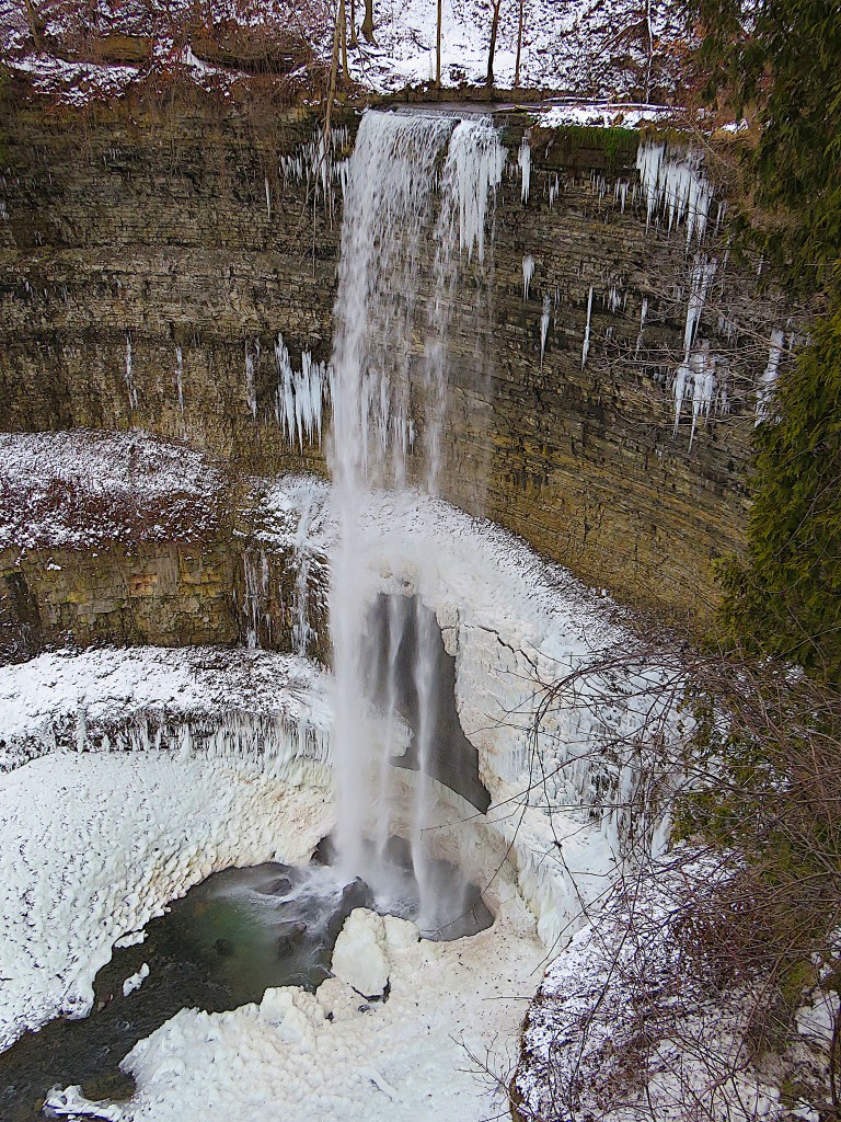
263. Tews Falls is every bit as awesome as Webster’s when there’s water going over it. It’s a ribbon waterfall, at 41 metres the tallest of the hundred or so in Hamilton (and considerably taller than the American Falls at Niagara). The stream that goes over it is Logie’s Creek, which meets Spencer Creek in the Y-shaped Gorge below. To get to Tews by car between December and April, take Sydenham to Harvest Road, turn left, then turn left again after 2.4 km. The entrance to the Tews P is controlled by an automatic barrier, and you either pay or swipe your HCA card to raise it. There are viewing platforms at two different levels; only the lower one is fully accessible.
Given their proximity to one another, you’ll probably want to visit both Webster’s and Tews on the same day. Absurdly, you’ll have to drive between them as the short Bruce Side Trail that connects the two falls has been barricaded shut by a local landowner.
Note: from May to November, you have to reserve a spot in advance to visit Webster’s, Tews, and the Peak. You park off site and get a shuttle in, and it will cost you plenty of money, time, and (probably) aggravation. So, better visit between December and April and wear shoes with gripping soles or cleats if there’s snow on the ground, as HCA doesn’t maintain the trails during this period.
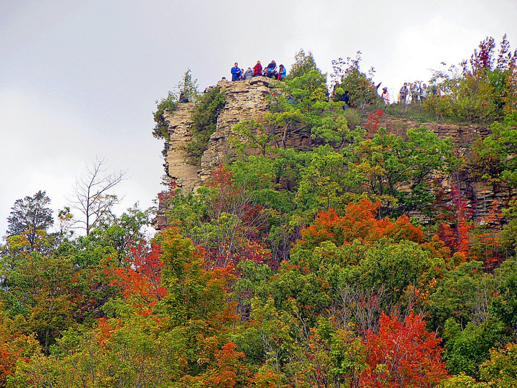
264. Once you have mounted the stairs to attain the higher viewpoint over Tews Falls, continue up the same trail for 1.5 km as far as Dundas Peak. This is a rocky ledge 110 metres up on the northern spur of the Escarpment, and it offers spectacular views over the Dundas Valley …
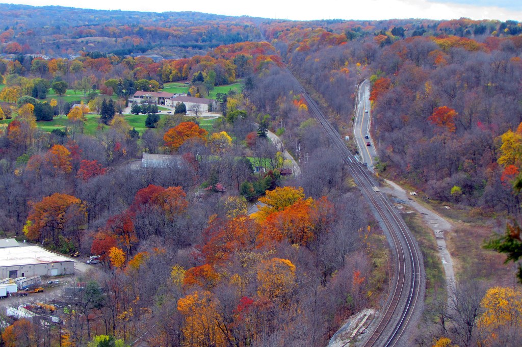
265. … the one above being the view west towards the head of the Valley in the fall, with the CN Rail lines running beneath. That bare spot to the right of the curve in the tracks is the former site of Dundas’s train station. To the right of it is the former Bruce Trail into Spencer Gorge, though CN now deny access to hikers at this spot. (It would be a simple matter to reestablish a safe crossing under the lines, which is how people used to get to the station, but there is no municipal will to do so.)
For obvious reasons, Dundas Peak is busy during fall. It has also been the site of much high-risk activity, e.g., by youngsters perched on precipitous ledges attempting to take the most dangerous-looking selfie. Such behaviour could have been greatly reduced if conservation officers had been assigned to monitor the site during busy periods. Instead, the HCA have tried to curb such activity on the cheap by erecting an ugly black fence around the edge of the Peak.
