From Rock Chapel Parking Lot to Old Guelph Road
Date: 28 August 2021
Start Point: Rock Chapel Parking Lot, 318 Rock Chapel Road, Dundas
End Point: Old Guelph Road at Highway 6, Dundas
Distance Covered: 3.8 km*
Total Distance Covered: 62.4 km
*plus ca. 3.8 km optional return loop.
287. This hike is only 3.8 km, but it can be quite challenging, especially after rain or snow. The stretch between Borer’s Falls and Valley Road descends into a ravine and climbs out of it again, and once you reach Patterson Road there’s a steep, rocky stretch back up to the edge of the Escarpment.
With two cars, park the start car in the Rock Chapel pay P, and the other in the free P where the dead end of Old Guelph Road abuts Highway 6. Note that the Rock Chapel P may be closed in the winter months. Note also that there is no access to the end P from Highway 6 itself. To get to it, go either east along Patterson Road or north along Old Guelph Road. Then take the short No Exit road at a three-way stop sign just before/after the road makes a right-angled turn. As usual, follow the white blazes of the main Bruce Trail between your start and end points.
With one car, you may want to park it for free at the end P and do the first leg of this hike counterclockwise. Whichever way you do it, the return loop is not very exciting: take Patterson Road instead of the Bruce, while otherwise retracing your steps. There’s not much traffic along Patterson Road, and it’s easier going than the Bruce that parallels it to the north. But don’t attempt to walk along any stretch of Valley Road! It’s a busy, steep, winding Mountain Access with no shoulders or sidewalks, and cars descend at speed, tearing around blind corners. Their drivers do not expect to encounter pedestrians.
It might actually be a good idea to do this hike one way, saving your energy for a post-hike side trip to the Arboretum of the Royal Botanical Gardens (RBG). You’ll have to get there by car: there is no public transit of any kind in this area on the Escarpment between Dundas and Waterdown. It’s only 3 km (a 5 minute drive) from today’s end point, or 5.8 km (a 7 minute drive) from the start point to the entrance of the Arboretum on Old Guelph Road. There’s plenty to see there at all times of the year and there are beautiful loop hikes on the north shore of Cootes Paradise.
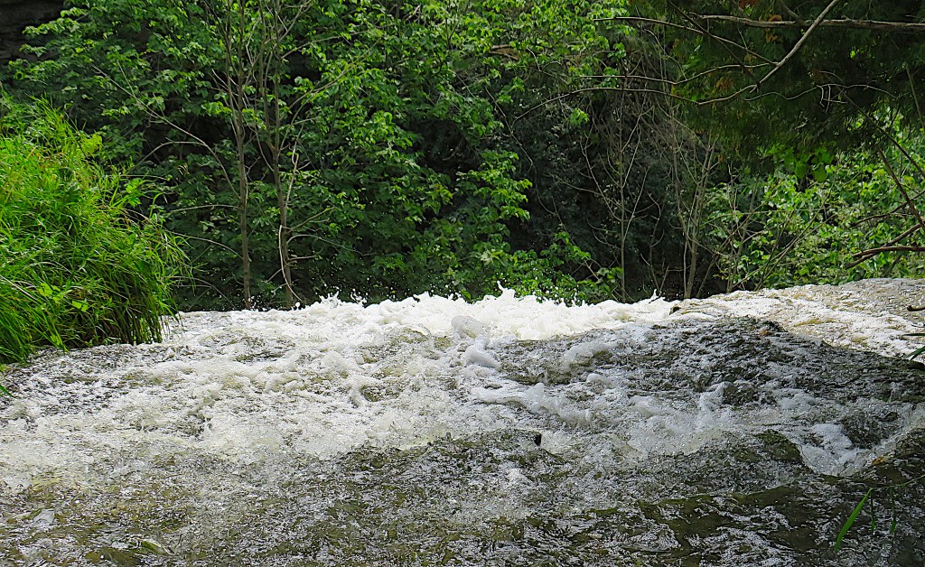
288. From the Rock Chapel P there’s a short section of trail that mostly runs inside a barrier along Rock Chapel Road but twice requires hikers to walk on the road itself. Be careful of traffic here. You go over a bridge near the lip of Borer’s Falls, where you can watch Borer’s Creek plunge abruptly over the steep edge. But to see the whole waterfall …

289. … continue on the Bruce as it heads south through an open area off Rock Chapel Road …
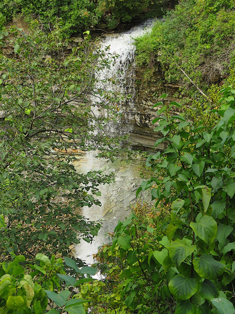
290. … after which there’s a small fenced viewpoint. Borer’s Falls is a ribbon waterfall 15 metres high, a pocket version of Tews Falls. It’s the second-to-last waterfall you’ll pass on the HOLO loop, and one of the most attractive. There was once a small village called Rock Chapel near the head of this Falls, centred on a sawmill owned by the Borer family. Rock Chapel, incidentally, was named for a clapboard church built in 1822 but long gone.
For the next 500 metres, the narrow trail hugs the very steep, unfenced edge of the Escarpment.
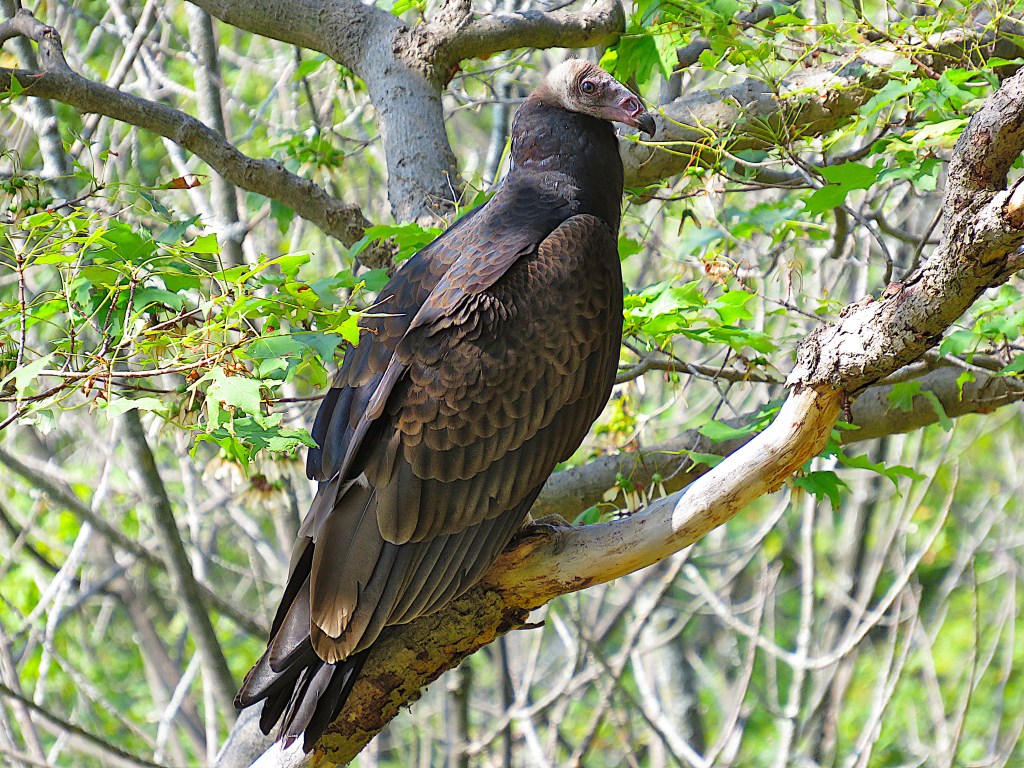
291. If you’re lucky, you’ll see a perched turkey vulture on this next stretch of trail. Unusually for the Niagara Escarpment, this section is south-facing and these birds like to warm up in trees facing the sun, sometimes spreading their wings. Turkey vultures (Cathartes aura) are very common over the Dundas Valley. They are magnificent fliers, soaring on afternoon thermals during most of the year, and sometimes gathering in the evening to roost on tall buildings in the Valley itself. In flight they can easily be recognized from their two-tone wings: silver-grey flight feathers with black linings. Up close, they are rather odd looking, the weird little head (reminiscent of a turkey’s) on a body the size of an eagle. They nest in cavities or rocky crevices near the top of the Escarpment, and feed almost exclusively on carrion, occasionally including roadkill.
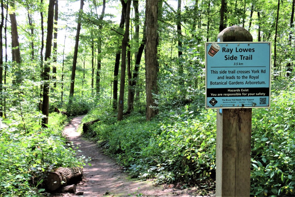
292. The main Bruce Trail is currently 904 km long, but that figure doesn’t include 462 km of side trails. These side trails, of varying length and marked with light blue signs and blazes, provide loops with the main trail or side trips to places of interest or to convenient parking. The main Bruce here connects with a side trail that commemorates the man who first conceived the Bruce Trail. Raymond Nicholson Lowes was born 1911 in Moose Jaw, SK and died at the age of 96 in Hamilton in 2007. He worked in the steel industry but loved the outdoors, and the idea of a hiking trail following the Niagara Escarpment from Queenston to Tobermory came to him in 1959-60. The full story is told in David E. Tyson’s book Trail to the Bruce (2017), pp. 13-16.
In a 1968 speech, Ray Lowes noted: “we should all have the opportunity to walk under ancient trees on a forest floor that is rich with the things that sustain life. It is this right of access to places of natural beauty that I plead for. We are poor indeed if we are so grasping for every dollar that we cannot afford this narrow strip of land across our Province for the good of all. The simplicity of our request is astounding! We just want a strip of land that will be left alone – not manicured, not landscaped, not serviced by multi-laned highways or “parkways”, and not through new subdivisions. It’s not much to ask. A later generation will demand it” (BTC Website).
Unfortunately, however, the information on the sign above, photographed in August 2021, is now no longer correct. The Ray Lowes Side Trail used to be 3.5 km long, leading from here on the main trail to Rasberry House in the RBG Arboretum, formerly the headquarters of the Bruce Trail Conservancy (BTC). But the BTC HQ has moved to Head Street in Dundas, and citing this move as an excuse, the RBG have barred pedestrian access to the Arboretum via York Road. In actuality, the closure of the York Road gate is almost certainly because it offered free entry to RBG property. The RBG are evidently ignoring that bit about “grasping for every dollar” in Lowes’s speech. The upshot is that since December 2021 the Ray Lowes Side Trail is now only 1 km long and ends at an off-leash dog park on York Road. Not a development that does anything to honour the distinguished memory of Ray Lowes.
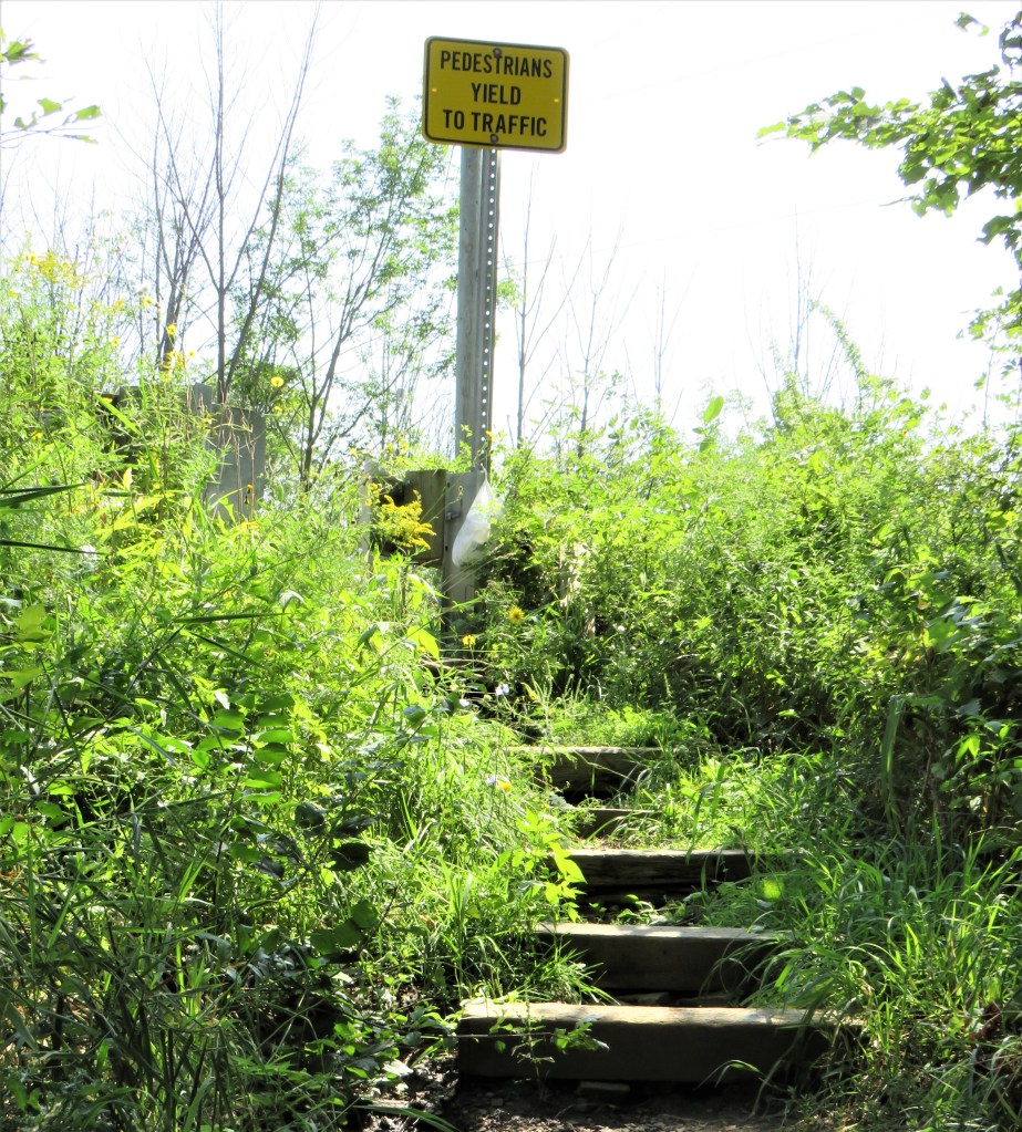
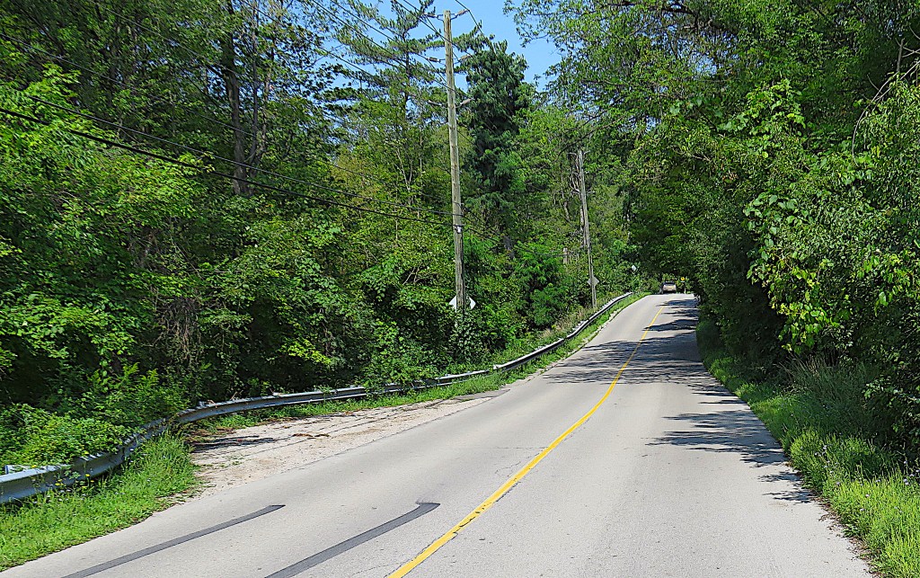
293. You descend much of the height of the Escarpment into a beautiful wooded ravine, cross little Hopkins Creek, and then ascend a short way until you reach Valley Road by these steps (top). The sign here expresses a harsh truth: do not expect traffic here or anywhere else at the Head of the Lake to yield to hikers. This isn’t the worst place to cross Valley Road (bottom), as you can see speeding traffic descending the Escarpment from some distance. Note: the speed limit is 50 km/h, but most cars will be coasting down at 60-70 km/h. So: don’t hike along Valley Road at any point, as it’s a roller-coaster with sharp curves, blind hills, and no shoulders.
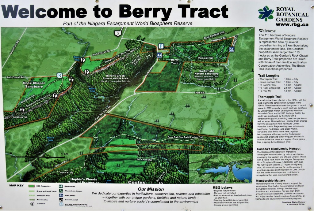

294. You now pass through a corner of the RBG’s Berry Tract. As it’s a great place to pick blackberries in summer, most people assume that’s how it got its name. Actually it’s named for one Alfred Berry, who bequeathed the property to the RBG in 1965. The Thornapple Trail is a forested walk through an overgrown apple and pear orchard and into an adjacent nature sanctuary. However, parking in the area is very limited and there’s no transit anywhere near.

295. Across Patterson Road, the trail starts to climb up to the brow of the Escarpment. This is one of the roughest, rockiest sections of the HOLO loop.
296. A snail with a housing problem: that’s one way of defining a slug. Slugs are molluscs closely related to snails, but have evolved without shells. Like snails, they are gastropods, literally “stomach-foot”: they seemingly slide around on their stomachs, though actually they move via muscular contractions of their flat underside, leaving a slime trail. As they don’t have shells, slugs are more vulnerable than snails to weather conditions, but that doesn’t stop them being notorious garden pests who devour fruit and vegetables faster than they can grow. This one is quite modest in size, perhaps 5 cm long, but there are giant spotted leopard slugs in Ontario up to 15 cm long. And slugs themselves are eaten by just about every vertebrate you can think of, humans included, so this one, if it stays exposed on that rock, won’t last long.

297. Towards the end of today’s hike, just off the trail, lies an abandoned skateboard park, covered with graffiti. There’s an abandoned outhouse on site too. Apparently this skate park was constructed from the concrete foundation of a demolished house. But by whom it was built, decorated, and provided with toilet facilities, and why it was subsequently abandoned, are questions so far without answers.
298. These yellow blooms stand tall by the side of the trail. They are Jerusalem artichokes (Helianthus tuberosus), a native plant that is neither from Jerusalem nor related to the artichoke. In fact it’s a kind of sunflower (Latin: helianthus). So how did it get its English name? The plant was brought from North America to Europe by the French explorer Samuel de Champlain, who noted that its edible tubers had a flavour similar to artichokes. The Oxford English Dictionary takes up the story: “The name … is considered to be a corruption of the Italian Girasole Articocco, or Sunflower Artichoke, under which name it is said to have been originally distributed from the Farnese garden at Rome soon after its introduction to Europe in 1617.” It’s considered a weed by farmers, as it outcompetes corn and soybeans and its extensive underground rhizomes make it difficult to eradicate. Its tubers, by the way, look like long, slender potatoes, and can be eaten raw. They have been consumed more frequently in the past than today, and Europeans have even made a kind of brandy, topinambour, from them. But the tubers will never match potatoes in popularity, probably because they often cause extreme flatulence in those who eat them!

299. Though the trail from Patterson Road seems to have been through a wilderness, it becomes clear that suburbia is not far away …
300. … and very soon you are standing at the top of a stairs with this view southeast over Highway 6. This stretch, that runs straight up and over the Escarpment here, connects Highways 403 and 401 and is the main route between Hamilton and Guelph. It’s sometimes known locally as the Highway of Death. That’s because, unlike conventional high-speed divided highways, its centre lane north of here is shared by vehicles making left turns from both directions, so head-on crashes are not uncommon. There are also many private driveways from which traffic joining the highway has no ability to merge at speed. Highway 6 runs 480 km between Port Dover on Lake Erie and Highway 17 west of Sudbury, via ferry from Tobermory on the Bruce Peninsula. On your next hike you have to cross it, but happily this won’t involve scurrying between the gaps in five lanes of speeding traffic.
301. And this is your end P: the north end of Old Guelph Road, with Highway 6 beyond the fence.
The Return via Patterson Road


302. Rustic Patterson Road is the low-key alternative to avoid retracing your steps on the Bruce. Even the road signs along it are … reticent.
“The Secret” by Denise Levertov (1923-97)
Two girls discover
the secret of life
in a sudden line of
poetry.
I who don’t know the
secret wrote
the line. They
told me
(through a third person)
they had found it
but not what it was
not even
what line it was. No doubt
by now, more than a week
later, they have forgotten
the secret,
the line, the name of
the poem. I love them
for finding what
I can’t find,
and for loving me
for the line I wrote,
and for forgetting it
so that
a thousand times, till death
finds them, they may
discover it again, in other
lines
in other
happenings. And for
wanting to know it,
for
assuming there is
such a secret, yes,
for that
most of all.
Side Trip: The Arboretum of the Royal Botanical Gardens
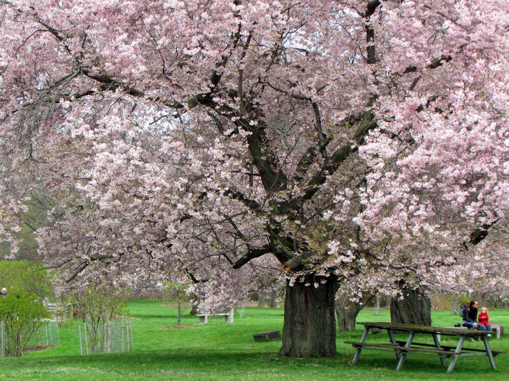
303. The RBG Arboretum is accessed by car via the main entrance on Old Guelph Road. It’s generally open from 8:00 am to dusk. RBG members park for free, while nonmembers pay $5 per hour to a maximum of $15. The Arboretum is delightful at every season, but spring offers particular highlights, including ancient cherry trees in blossom …
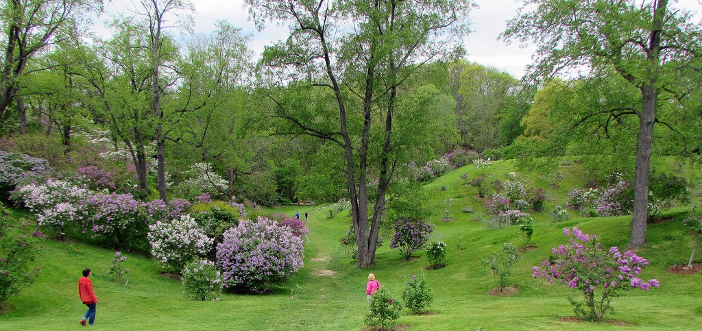
304. … and a lilac dell with dozens of varieties on show.
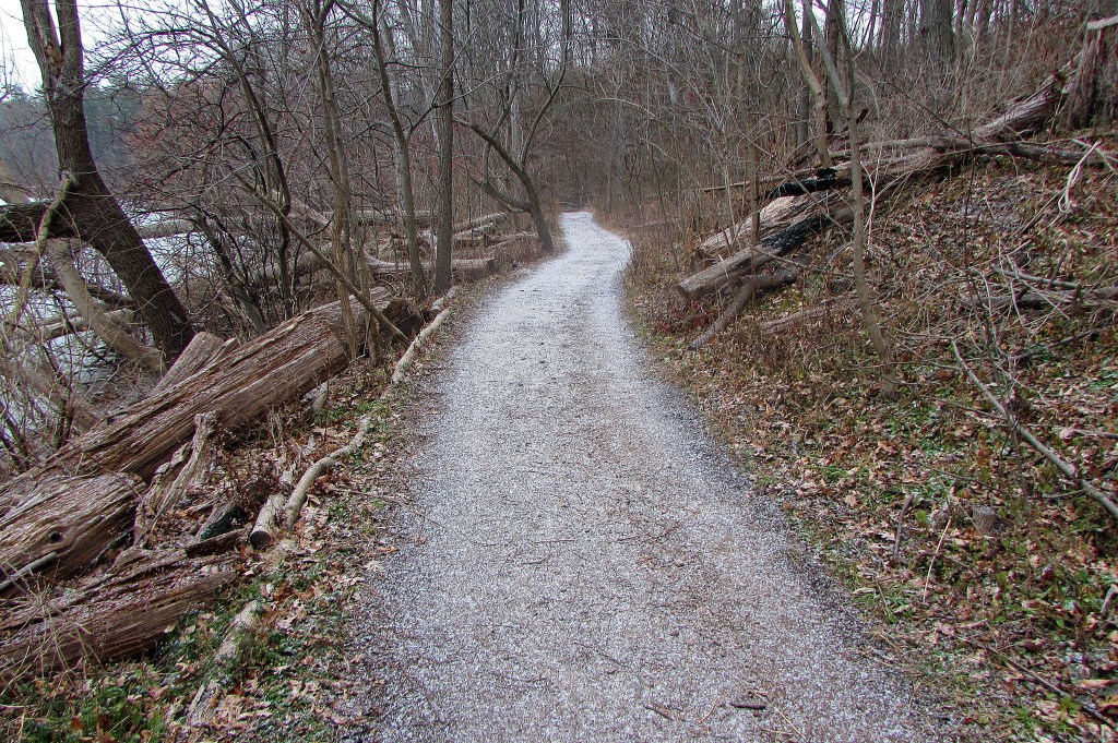
305. Even in winter Arboretum trails remain accessible. Anishinaabe waadiziwin is a newish trail along the shore of Cootes Paradise that provides insight into First Nations’ relationship to nature …
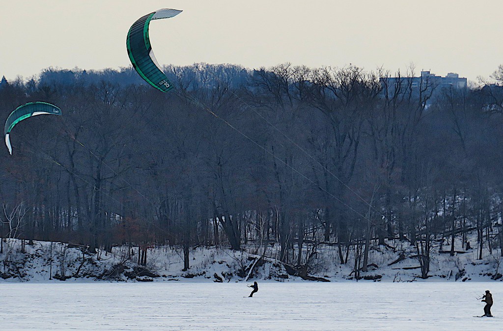
306. … and from it, on cold winter days, you can watch kite skaters glide across on the frozen surface of Cootes Paradise. (Or try it yourself!)
