Part 38: Campbell’s Hill to East Back Line
Date: 23 September 2019
Start: Campbell’s Hill, Grey Highlands
End: East Back Line, Flesherton
Distance covered: 11.9 km
Total distance covered: 474.8 km

464. Shortly after leaving our start point on Campbell’s Hill, we meet Dean from Crystal Beach, Ontario coming the other way. Like us, he’s a retiree who decided that a Bruce Trail end-to-end hike would be a good way of celebrating the end of gainful employment. Unlike us, he’s doing the Trail north to south, on his own, and all in one go, having left Tobermory a mere two weeks ago. We have nothing but admiration for his pluck, determination, and stamina. Safe trip, Dean!
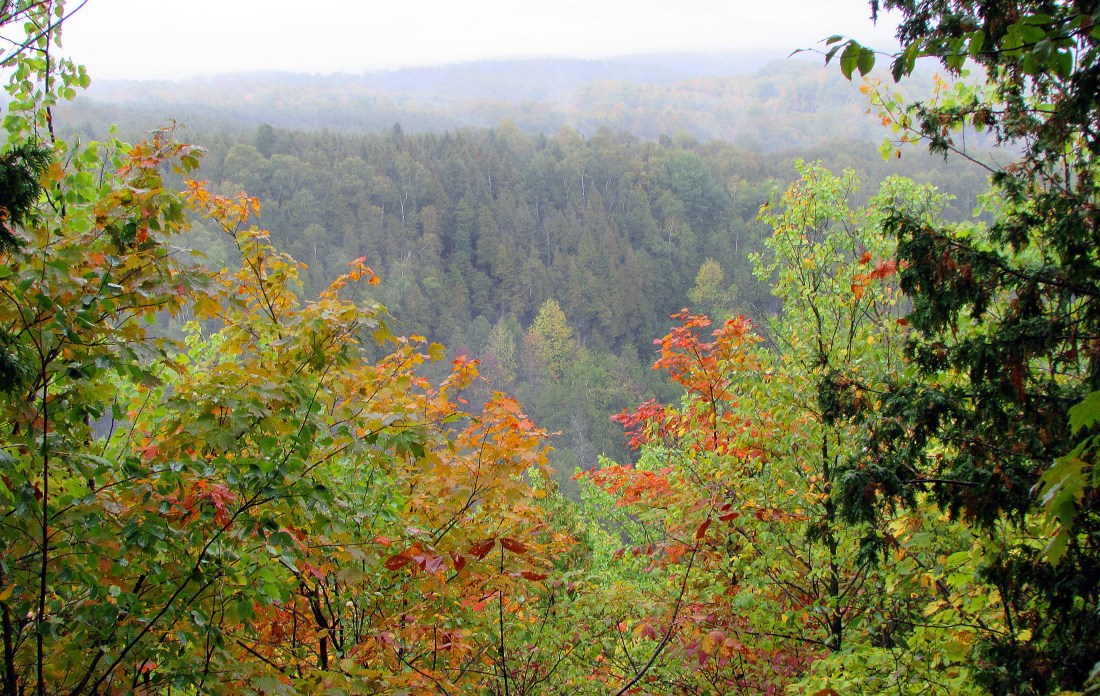
465. The beautiful Beaver Valley looking misty and autumnal, with more than a few hints of the fall multicolour spectacle to come.

466. We are baffled by this stone arch that apparently serves no useful purpose. Bruce Forsyth’s Canadian Military History website provides the answer: “This stone arch was once the entrance to a long-vanished tunnel intended to be used in conjunction with a long abandoned hydro-electric power project. Built by the Georgian Bay Power Company between 1906 and 1907, the tunnel was dug through the hill beside the top of the falls to the valley floor below. The plan was to divert the river through the tunnel in an attempt to maximize the drop, thus increasing the generation capacity of Eugenia Falls. … Construction costs on the tunnel exceeded the million dollar mark (approximately $27.2 million today). … The tunnel was 867 feet long, 9 feet high and 8.5 feet wide, and was big enough to drive a buggy through it, which one person actually did. A Roman-style stone arch was constructed at each end of the tunnel but in the end, all the effort was for nothing. The Beaver River’s capacity proved to be insufficient and the tunnel was never used. The whole project was eventually abandoned and the Georgian Bay Power Company went bankrupt.”

467. Eugenia Falls is a 30-metre waterfall, the tallest in the area. The Trail, making a U-turn just south of here, passes the Falls on both sides of Beaver River, and this is the view of the lip from the right bank. Eugenia, which is the name of the nearby village and Lake on the east side of the Valley, was named for Eugénie, the wife of French Emperor Napoleon III, by French soldiers employed in a survey party in 1862. The exotic street names of Eugenia village also recall French military history: Napoleon, Inkerman, Canrobert, Zouave. But what kind of woman was the Spanish-born, long-lived, last Empress of the French (1826-1920)? Eugénie served several times as a diligent regent in her husband’s stead and advocated for women’s rights; she was also a pious, conservative Catholic who found physical relations with her husband disgusting. She spent most of the last 35 years of her life in exile in England, and is buried in Farnborough, Hampshire.

468. On the west bank of the Beaver near Eugenia Falls stands this graffiti-covered ruin of a stone building, once a power generating plant. Bruce Forsyth explains: “This was the second attempt at hydro generation at Eugenia Falls, the first being built in 1893 by local businessman William Hogg … Unfortunately Hogg’s paddlewheel generator was only able to generate 70 kW, barely enough electricity to power Eugenia and nearby Flesherton.”
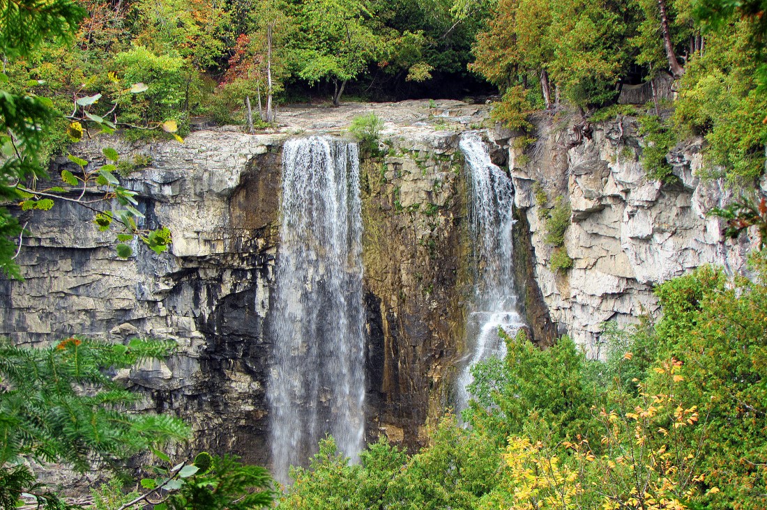
469. The left bank of the Beaver River offers a more comprehensive view of Eugenia Falls. Yet even from here it isn’t possible to see the whole height of the waterfall as the vegetation is too dense at this time of year. The Falls was discovered by a man named Brownlee in 1852, who, seeing a glint in rocks at its foot, thought he’d discovered gold. This led to a gold rush of more than 200 stampeders lasting all of three weeks and producing 200+ red faces. What Brownlee had spotted was iron pyrite, a.k.a. fool’s gold. But that embarrassment doesn’t stop present-day Eugenia from holding an annual Gold Rush Days festival.

470. Mature honey mushrooms (Armillaria mellea) (if that’s what they are) are clustered in their dozens around the base of a stump. As their name suggests, these are edible if cooked, at least if you’re not allergic to them. They are also bioluminescent, producing a greenish glow at night. I say, “if that’s what they are,” because even expert mycologists on site can’t always be sure of correctly identifying fungi. I’m no expert and I’m making my identification from a photograph. I gather the very similar Jack O’Lantern mushrooms (Omphalotus illudens) are also bioluminescent, but are quite poisonous.


471A & B. A sign here near Lower Valley Road indicates that this tangle of plastic tubing by the Trail is a “Maple Installation” by a firm specializing in organic, sustainably-produced maple syrup. This syrup is made from the sap of various kinds of maples. “In cold climates, these trees store starch in their trunks and roots before winter; the starch is then converted to sugar that rises in the sap in late winter and early spring. Maple trees are tapped by drilling holes into their trunks and collecting the exuded sap, which is processed by heating to evaporate much of the water, leaving the concentrated syrup. Maple syrup was first made and used by the indigenous peoples of North America. Canada produces more than 80 percent of the world’s maple syrup” (Wikipedia).

472. Tamarack, or American larch, in an open, marshy area near Hogg’s Falls. Tamarack is that anomaly, a conifer whose needles are deciduous … and are now turning autumnal yellow. These trees like swamps and bogs, are very hardy and cold resistant, but do not like shade. The word tamarack possibly derives from Abenaki, an Algonquin language, and is thought to be a reference to the fact that the tree’s supple wood was good for making snowshoes.

473. A green frog, which differs from a bullfrog in that it has two ridges (dorsolateral folds) running down its back. This rather splendid specimen poses on the Trail long enough for me to get this close-up. It’s a male, as its tympanum (its circular external hearing structure) is larger than its eye. An interesting fact about these amphibians is that individuals appear to be able periodically to switch sex, though it’s not clear why.

474. A pile of large, recent droppings lies on the Trail. It sure looks like moose poop to us! Are moose to be found in Beaver Valley? There’s no official moose hunting season in this part of Grey County. Yet moose do sometimes crop up as far south as the northern suburbs of Toronto …

475. What’s Nick looking so smug about? Someone please remind him that, including the 34.2 km omitted, he still has more than 400 km of Trail to negotiate. This is merely the southernmost point of the Beaver Valley Club Section, a long, tight, southerly droop. From here the Trail will head almost unremittingly north and west, and this will probably be the last time that it’ll take less than two hours to get from home to our start point.
Go to Part 39: East Back Line to Grey Road 30
