
Part 62: Brock Street to Rush Cove Side Trail
Date: Monday 21 September 2020
Start: Brock Street, Hope Bay, South Bruce Peninsula
End: Rush Cove Side Trail, Northern Bruce Peninsula
Distance Covered: 15.5 km
Total Distance Covered: 781.3 km

767. The waterfront at Hope Bay near the start of today’s hike. The weather is, for once, absolutely perfect for hiking (sunny, cool, calm), which is just as well, as we have a long haul ahead of us from left to right along that ridge across the water, then round the tip of Cape Dundas. Hope Bay (also the name of the bay itself) has a campground with a small store (closed today) at the entrance, but it’s not really a village but a cottage road along a beach strip that has become suburbanized. And now, here’s a puzzle: what is odd about all the images of sky over lake, including this one, that I’ve presented since we first started following the Georgian Bay shoreline? Please see #774 below for the answer.
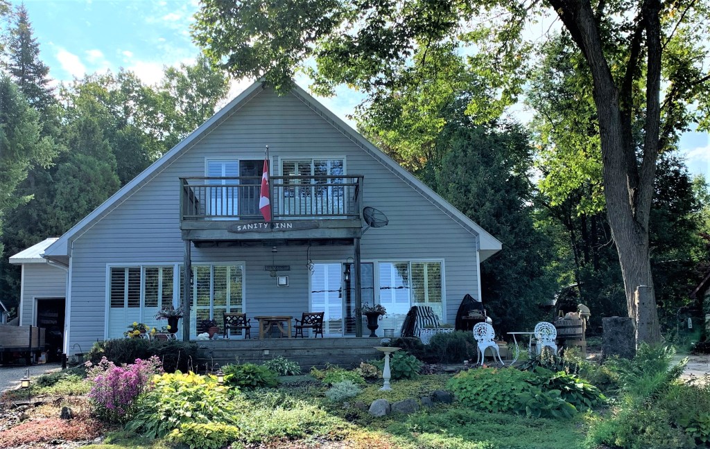
768. The houses in Hope Bay are generally much larger than weekend cottages, hence my term “suburbanized.” Here’s the dwelling with the wittiest name.
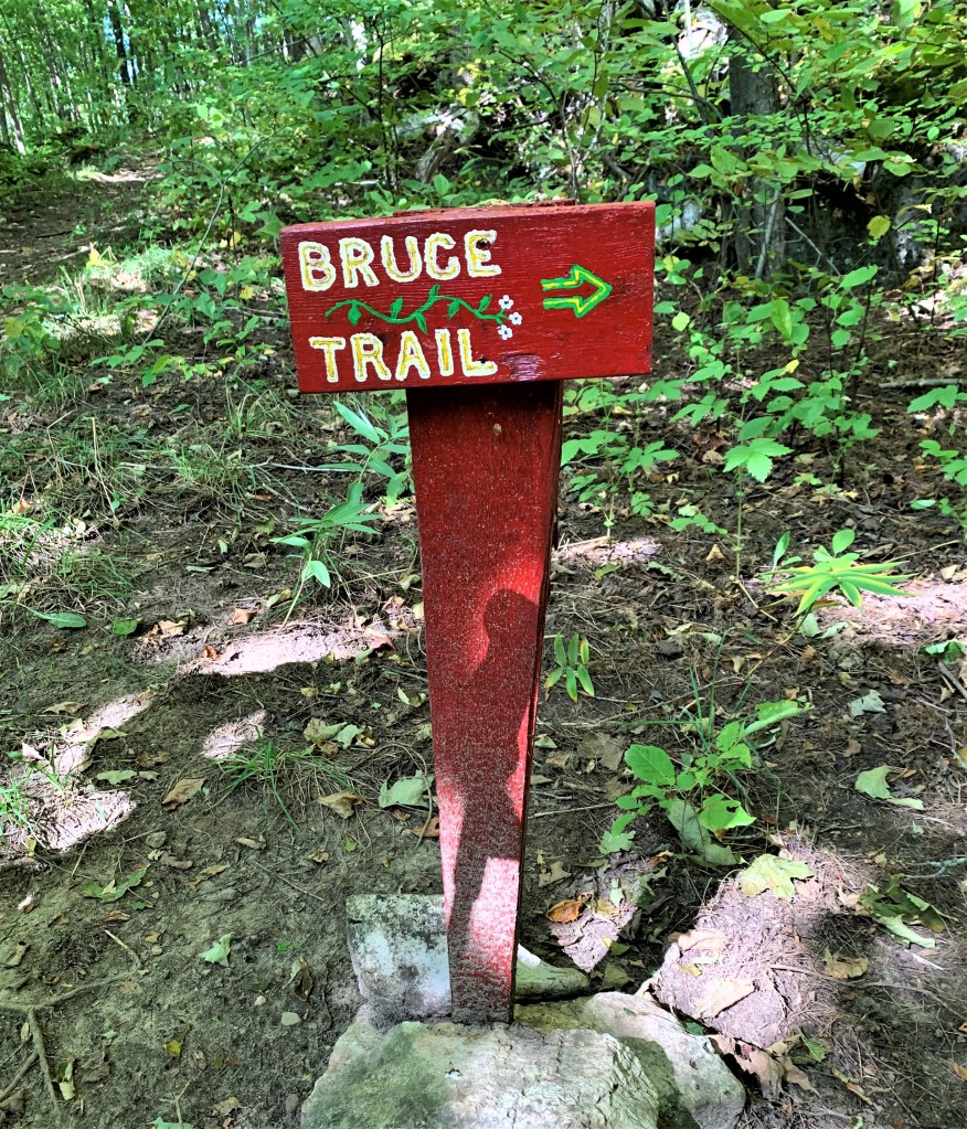
769. An unofficial but cute hand-painted sign guides hikers up the Escarpment from Hope Bay. And it reminds me that I haven’t yet accounted for the “Bruce” in the name of the County, nor of the Peninsula, nor of the Trail itself. Alan Rayburn in Place Names of Ontario notes that Bruce County was named for James Bruce (1811-63), 8th Earl of Elgin and 12th Earl of Kincardine, during whose term (1847-54) as Governor General “responsible government was introduced” into what was then the Province of Canada (p. 46). That is, Lord Elgin distanced himself from politics and so began the tradition that the Governor General should play chiefly a symbolic role in the nation’s affairs. (It was Elgin’s father, the 7th Earl, who was controversially responsible for shipping the Parthenon sculptures known as the Elgin Marbles to the British Museum.) The Bruce Peninsula was referred to by early white settlers as the Saugeen, or Indian Peninsula, but as the native population was forced into smaller and smaller areas by colonial settlement, it came to be known by the name of the County. As for the Bruce Trail, The Bruce Beckons: The Story of Lake Huron’s Great Peninsula (1952) by the classical scholar William Sherwood Fox had a large part to play. This book “described the flora, fauna, and physical beauty of the Bruce Peninsula in such a lyrical and compelling fashion that the Bruce became a mecca for naturalists” (David E. Tyson, Trail to the Bruce, p. 25). So the Bruce Trail was named indirectly for a Scottish nobleman and directly for the Peninsula that served as its dramatic climax, and Bruce Trail was preferred to alternatives (as Tyson notes) because the phrase “was nice and short and would fit easily on signs” (like the one above). [Addition 30 March 2021: The sign above was painted by local resident Laura Browne to help Bruce hikers, too many of whom were missing the turn indicated. Thanks, Laura!]

770. Geological traces of the prehistoric landscape in these parts. This rounded notch in the cap of the Escarpment was carved out by wave action when the water level of Georgian Bay was much higher than it is today …

771. … and this glacial pothole in the cap of the Escarpment dates from about 10,000 years ago, the end of the last Ice Age, when glacial meltwater carrying harder rocks eddied with such force that almost circular cavities like this one were scoured out of the softer limestone.

772A & B. You can’t see it from up here, but Water Street, a cottage road in Hope Bay, runs directly under this viewpoint. Never mind human vandals: if you live too close to the edge or foot of a highly active geological formation like the Niagara Escarpment, you’re going to be at the mercy of the combined forces of rock and gravity. Ah, but the view …
773. The view east over Shoal Cove, a sheltered spot for canoeists to pause and picnic when following the lakeshore. That’s Sydney Bay Bluff across Hope Bay. There is still only a slight trace of fall colour in the leaves of the deciduous trees.

774. Forest in the foreground, Hope Bay (one power boat, one sailboat) in the middle distance, Cape Croker on the horizon, and above it all, an almost cloudless sky. So did you solve the puzzle I posed in #767? The answer is that in none of the images can any vapour trails be seen. During the Covid-19 pandemic Canadian airlines have seen a more than 90% reduction in passengers. Having flown into Toronto from western Canada many times, I often recall seeing the Bruce Peninsula below, a sign that the plane would soon be starting its descent into Pearson. The pristine blue of the sky in the image above is striking evidence of one way the world has changed in the past seven months.

775. We know all about the damage that ATVs inflict on the terrain, but what on earth is an alvar?

776. An alvar is a limestone terrace that supports at best a very thin mantle of soil in which only hardy vegetation, much of it often rare, can grow. Alvar is a Swedish word meaning just such a geological formation, and that’s because the classic site is on the Swedish island of Öland in the Baltic: Stora Alvaret [the Great Alvar], the largest in Europe.

777. The Swedish one is 40 km long. This one between Cape Dundas and the shore of Georgian Bay is much smaller, perhaps 1.5 km long. That’s creeping juniper carpeting the ground.

778. “Walk with a cautious step for we are not masters, only custodians.” This plaque honours the anonymous donor who in July 2017 gave the Bruce Trail Conservancy its largest ever land donation: 230 acres here at Cape Dundas. You can read the donor’s moving speech about the motive for the donation here.
779. Patches of grey lichen and a dwarf kind of goldenrod (possibly Solidago speciosa) are typical alvar features.

780. The height of Cape Dundas viewed from the lakeshore alvar. This Cape, and the semi-enclosed stretch of Georgian Bay named Melville Sound to the east, both commemorate Henry Dundas, 1st Viscount Melville (1742-1811), the powerful, influential, morally obtuse Scottish Tory politician who never visited Canada but who happened to be a friend of John Graves Simcoe, Upper Canada’s first Lieutenant Governor. Henry Dundas may be the most over-memorialized man in Ontario. By a process too complicated to summarise here, his name became attached to the many Dundas Streets that link some of the oldest settlements in southern Ontario, as well as to the historic valley town, now technically part of Hamilton, that contains the headquarters of the Bruce Trail: see #134, #139 above. A petition, inspired by the Black Lives Matter movement, was recently circulated to change the name of Dundas Street in Toronto, because Henry Dundas is thought by many historians to have deliberately thwarted early passage of legislation to abolish slavery in the British Empire. Whether the renaming initiative will reach as far as this part of the Bruce Peninsula remains to be seen. [Possible correction to #779] In the article by James White cited in #789 below, White infers from circumstantial evidence that Cape Dundas and Melville Sound were named for Robert Saunders Dundas, 2nd Viscount Melville (1751-1851), so not (as I had assumed) for his father Henry Dundas. This is certainly possible, as Robert Dundas was First Lord of the Admiralty (1812-27) during Bayfield’s survey of Lake Huron.
781. The waters of Georgian Bay are cold and remarkably clear, as here where the Trail, approaching today’s Rush Cove end point, runs along the shore. In Tobermory, there is only one month, August, when the water temperature climbs above 20C, that is recommended for swimming. By now (late September), the temperature is usually 14C or less.
