
Part 61: Coveney’s Side Trail to Brock Street
Date: Tuesday 15 September 2020
Start: Coveney’s Side Trail, South Bruce Peninsula
End: Brock Street, Hope Bay, South Bruce Peninsula
Distance Covered: 12.6 km
Total Distance Covered: 765.8 km
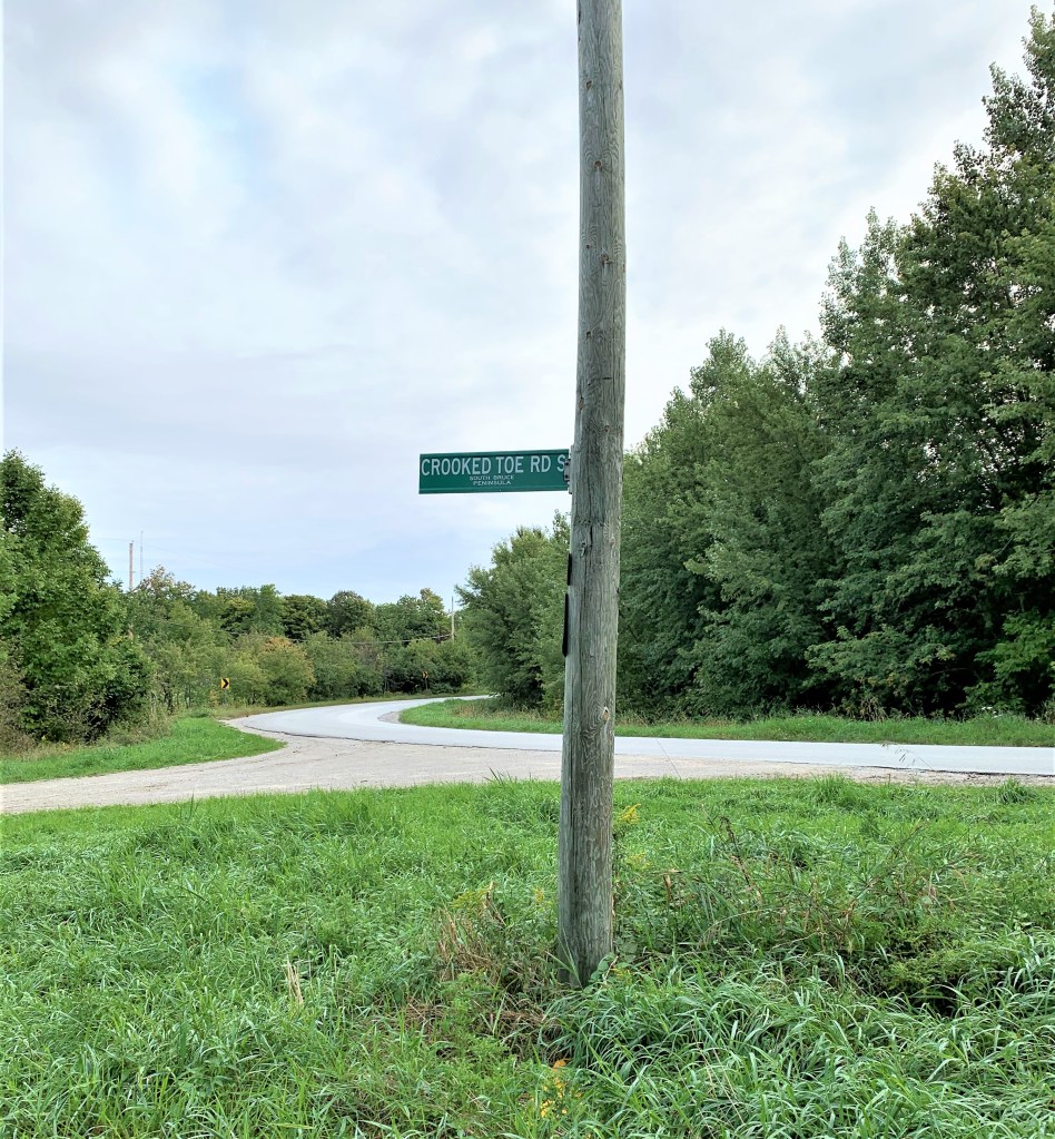
754. Today’s hike, starting from our parking place on memorably-named Crooked Toe Road, will be an adventure more unpredictable than usual. Because of the closure to outsiders of Neyaashiinigmiing territory, the Main Trail has been rerouted for all but about 2 km of today’s hike. It will be interesting to see whether there is signage in place to help us on our way. (No, I can find no explanation why Crooked Toe Road is so called.)
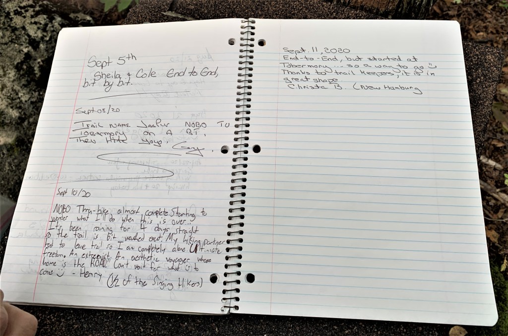
755. We haven’t seen one of these for a while. It’s a notebook left in a box near Coveney’s Hill in which passing hikers are encouraged to register their thoughts. The most recent pages suggest that Bruce Trail traffic is light at this time of year: only four entries in the last ten days, and four days since the last entry. The most interesting piece is headed Sept 10/20: “NOBO [i.e., he’s going northbound, like us]. Thru-hike, almost complete. Starting to wonder what I’ll do when this is over … It’s been raining for 4 days straight so the trail is a bit washed out. My hiking partner had to leave trail so I am completely alone. Ultimate freedom. An extremist. An aesthetic voyager whose home is the ROAD! Can’t wait for what is to come:) – Henry (½ of the Singing Hikers).” Well, Henry, we’re sorry about the recent weather and that your other half had to leave the Trail, though you sound as if you have the will to survive the Loneliness of the Long-Distance Hiker. After all, it’s not such a long way to Tobermory from here. And you should know that Mike and I, too, are starting seriously to wonder what on earth we’ll do when this is over …
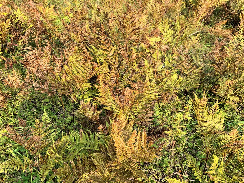
756. The dense bracken in a marshy area near McIver Pond is turning an autumnal brown. Autumnal was my spontaneous choice of adjective for this scene, but here in Canada the season between summer and winter is known as fall, a noun that can also be used adjectivally. So what accounts for my nonstandard diction? The Old English word for the season was hærfæst (compare modern German Herbst), which survives in modern English as harvest but has come to mean a specific seasonal activity, not the season itself. In Chaucer’s time, the Middle English word was autumpne, a borrowing from both Latin autumnus and French automne. By the 16th century (we are now in the Modern English period) fall was quite widely used in Britain as a short form of the phrase fall of the leaf, and it was this term that remained in American English while in British English autumn became standard by the end of the 17th century. Canada, unusually in this case, preferred the American usage from the start: the Quebec Gazette of 5 January 1767 notes: “A few barrels of pickeled cod fish, taken … last Fall.” A recent language commentator on CBC radio speculated that the North American preference for fall comes from the spectacular colours of deciduous leaves in the northeastern part of the continent, outdazzling anything a dull British autumn can offer. I feel that this is probably true, insofar as these vibrant colours are found in eastern Canada too and that explains why English Canadians went for fall rather than dull old autumn. But the English language is richer for having at least two words for almost everything, and my choice of autumnal to refer to the ferns above is I think appropriate, as their rusty colour is subdued and so … British!
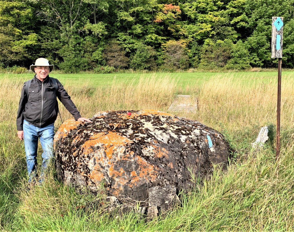
757. Nick poses by a lichen-decorated boulder in the middle of an open field. Someone has placed a red apple on its top, like a cherry on a huge lump of tiger tail ice cream. The blue diamond and blaze on the right indicate that we are on a Side Trail, in this case the McIver, that keeps south of the boundary with Neyaashiinigmiing.

758. A physical barrier on McIver Road stops traffic from entering the Neyaashiinigmiing Reserve. (The reason why the Reserve is off-limits is discussed in #749 above.) From this point we have an on-road hike west on McIver Road then north on Purple Valley and Pit Roads.

759. A close-up of the Neyaashiinigmiing welcome sign in the previous photo. A recent press release has good news regarding the ongoing SON [Saugeen Ojibway Nation] land claim: “After several years of discussions, Grey County and SON have reached a settlement that includes the transfer of approximately 275 acres of County forest in Georgian Bluffs known as the Mountain Lake forest property… . The full terms of the settlement are confidential, but Grey County has included the property in the settlement in the spirit of reconciliation, and without any admission of liability on the County’s part. ‘This settlement provides some closure to a long-standing claim, but I hope it can also be the beginning of more conversation, more understanding and a stronger relationship between Grey County, SON and the Anishinaabe people,’ said Grey County Warden Paul McQueen. ’This agreement is an important step forward in a long history of our communities working towards righting a wrong,’ says Chief Lester Anoquot of Chippewas of Saugeen First Nation. ‘We are happy and hopeful that we are taking this step with our neighbours towards building a better understanding and a stronger future alongside one another.’”

760. A Virginia tiger moth caterpillar (Spilosoma virginica) sports a punk hairdo.

761. A V-formation of geese against grey sky over an open section of the Trail on Purple Valley Road is a harbinger of fall, though technically there’s still one week of summer to come. (I should perhaps have made this point in #756 above.)
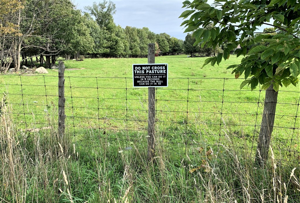
762. We love this sign. However, the bull in question seems too shy and retiring to greet us … and we wonder how his owner managed to time him so precisely over the said distance …

763. This part of the hike is rerouted along the Boundary Bluffs Side Trail. The Bluffs in question, a section of the Escarpment with exposed white dolomite, loom ahead. The Side Trail itself, following an almost dead straight road allowance, is in a depression that is soaking wet, necessitating a long wade through waist-high goldenrod on slightly higher ground.


764A & B. Once we’ve climbed the Escarpment, we are redirected along the Hart’s Tongue Side Trail. This trail runs across the base of Cape Paulett, the little peninsula immediately to the west of Cape Croker and divided from it by Sydney Bay. At the same time, the trail runs just south of and almost parallel to the boundary with Neyaashiinigmiing, and will reconnect us with the Main Trail east of Hope Bay. Meanwhile, the name of this Side Trail is a provocation, as it suggests that the rarest of native ferns (Asplenium scolopendrium) line its 1.9 km length. Hart’s tongue ferns are far too shy to flaunt themselves thus, but the challenge to spot at least one of them cannot be shirked. And eventually one is located, hiding in a shaded rocky crevice less than a metre from the Trail. It’s a much finer example than those depicted in #676.

765. Much more common along this Side Trail are maidenhair ferns (Adiantum pedatum). Another, more descriptive name for them is “five-fingered ferns,” as each plant radiates like the five digits of an open hand. They are somewhat similar to, but not to be confused with, the much smaller maidenhair spleenwort (Asplenium trichomanes; see #442). The “maidenhair” part of these ferns’ name may be because the drooping leaves of a close fern relative, Adiantum capillus-veneris, do look a bit like delicate girlish hair. Moreover, the leaflets of this relative resemble the leaves of the maidenhair (i.e., ginkgo) tree. However, it is likely that both the tree and the spleenwort were named for their resemblance to two different ferns, only one of which resembles the hair of a maiden, if that makes any kind of sense. Whatever the case, the ferns above have picked up the “maidenhair” epithet only by indirect association.
766A & B. A steep but sturdy ladder (without a handrail) takes us down the sheer cap of the Escapment, after which we descend more gradually to our end point at Brock Street in Hope Bay. The Bruce Trail’s complicated reroute to avoid Neyaashiinigmiing territory has been reasonably well signposted and has taken us through varied and interesting terrain. It has also reduced for us the total end-to-end length of the Trail by about 10 km.
