Part 64: Forbes Street to Cape Chin Side Trail
Date: Sunday 27 September 2020
Start: Forbes Street, Lion’s Head
End: Cape Chin Side Trail, Lion’s Head
Distance Covered: 16.0 km
Total Distance Covered: 808.8 km
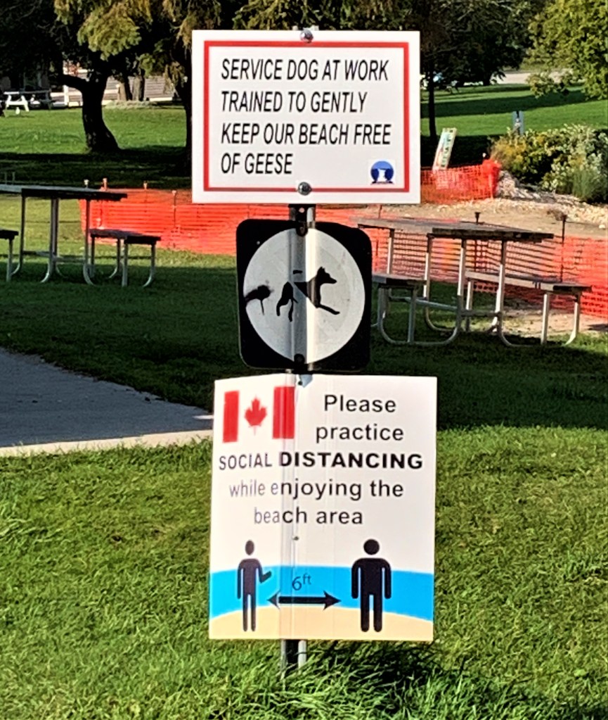
794. Signs in the beachside park at Lion’s Bay inform visitors of the ingenious local sanitary arrangements and remind them of pandemic protocols …


795A & B. … with mixed results.
796. Lion’s Head was first called Point Hangcliff. Then in 1875 it was given its present name because the profile of the headland above reminded people of a lion’s head. Later still, according to some authorities, the leonine formation crumbled away into Georgian Bay. However, you can find recent photos online of a coastal formation that very much resembles a lion’s head, with foliage representing the mane. You can’t see this “lion” from here in the harbour, however. What you can do, like the couple at right, is photograph your own head in a frame that includes the putative lion.

797. The skeleton of a giant marine dinosaur? An alien visitor that has succumbed to a terrestrial virus? A surrealistic sculptural installation? Or a piece of driftwood that makes an uncomfortable bench for the contemplation of Isthmus Bay from Bannister’s Hill?
798. A colourful fall display in one of the front gardens on Isthmus Bay Road.

799. A disconcerting scene unfolds farther along Isthmus Bay Road. A young man is hanging from the passenger window of a parked car, and he is retching violently into the middle of the road. Embarrassed and a little anxious — is this The Virus at work? — we pass by quickly, keeping our distance and averting our eyes. But in between heaves, he calls out to us: “Don’t drink the lake water!” Georgian Bay water is typically cold and crystal clear, so it’s tempting on a hot day to quench one’s thirst with it. But is it safe to do so? The Georgian Bay Association replies: “Although our water appears pristine, that cannot be taken as a guarantee of their [sic] potability (i.e. safe to drink). The GBA urges all cottagers, boaters and campers to take measures to ensure their water is safe to consume. All surface water (water taken from a river, a stream or a lake rather than from a deep well) in Ontario should be treated to remove bacteria, viruses and parasites.” In short: no, it’s not safe to drink untreated lake water, however pure it looks. (Later, we speculate that the young man had probably drunk too deeply of liquids other than lake water.)

800. Our eight-hundredth kilometer is marked by a fine view over Whippoorwill Bay, with White Bluff on the horizon at left. We’ll be going quite a lot farther than that headland today.

801. With a wave from its driver, a historic vehicle passes us on Isthmus Bay Road. Eighty years ago, 1,525 of these LaSalle two-door sedans were built, each costing US $1,180. 1940 was the end of the line for the LaSalle, a General Motors marque created in 1924 as a slightly less expensive companion to the Cadillac. Incidentally, what LaSalle and Cadillac have in common is that they were named for French explorers of North America: LaSalle after René-Robert Cavelier, Sieur de La Salle (1643-87), explorer of the Great Lakes and the Mississippi River; and Antoine de la Mothe, Sieur de Cadillac (1658-1730), one of the founders of Detroit and explorer of New France, i.e., the region between Québec and Louisiana.

802. Isthmus Bay Road has an assortment of properties from modest cottages to mansions. None, however, has a more eccentric frontal display than this house.
803. As we approach White Bluff, the Trail runs through the middle of an open field parallel to lakeside Whippoorwill Road.

804. A rural ruin evokes melancholy thoughts of those who once called this place home. One great poet was a master of this theme:
“Meanwhile her poor hut
Sunk to decay, for he was gone whose hand
At the first nippings of October frost
Closed up each chink and with fresh bands of straw
Chequered the green-grown thatch. And so she lived
Through the long winter, reckless and alone,
Till this reft house by frost, and thaw, and rain
Was sapped; and when she slept the nightly damps
Did chill her breast, and in the stormy day
Her tattered clothes were ruffled by the wind
Even at the side of her own fire. Yet still
She loved this wretched spot, nor would for worlds
Have parted hence; and still that length of road
And this rude bench one torturing hope endeared,
Fast rooted at her heart, and here, my friend,
In sickness she remained, and here she died,
Last human tenant of these ruined walls.”
— William Wordsworth (1770-1850), The Excursion, book 1 (“The Ruined Cottage”) (1814).

805. A survey monument disc next to the Trail, pinned into rock by Hewett & Milne, a company of surveyors in Owen Sound. Such benchmarks were set in the ground as hard evidence of legal boundaries, with the indirect aim of maintaining peace and order between neighbours. “Ontario regulations require that [survey monuments] be set by Ontario Land Surveyors (OLS) at all property corners and at regular intervals on boundaries. They may consist of, for example, 25 mm or 16 mm square steel bars, or 25 mm plastic bars, of up to 1.2 m length, set vertically in the ground with tops flush to or near grade; or they may be pins set in rock, or crosses cut in concrete.” As this disc states, it is a criminal offence to remove such monuments, though the law is rarely enforced.

806. This is a reverse angle view of the one in #800 above. From the top of White Bluff looking south, we can see most of Whippoorwill Bay, with Isthmus Bay Road visible along the far shore.
807. After a long haul along the top of the Escarpment through Smokey Head – White Bluff Provincial Nature Reserve, we descend to the lakeshore and turn left (northwest) …

808. … and walk along the beach itself, where we can view the pebbles close up. This beach would be a paradise for stone skippers, skiffers, skimmers, dappers, ducks-and-drakes specialists, and artistes de ricochet! Skipping (when bounces are counted) and skimming (when distance is measured) are a serious business these days. The world record for skipping is a scarcely credible 88 skips, captured on YouTube, while the distance record for skimming is an equally amazing 121.8 meters, also viewable on YouTube.
809. Here the Trail follows a raised platform of pebbles along the shoreline. There’s a dip down, then there’s a ridge of pebbles thrown up by wave action along the water’s edge.
