

Map 25. This takes us from A, where Dundas Street leaves Oakville and, as Dundas Street West, enters Mississauga at Winston Churchill Boulevard, to B, where Dundas Street West crosses Hurontario Street (20 on the map) and becomes Dundas Street East.
There’s a striking difference between the original Dundas Street and this one, its later eastern extension. The former links several significant settlements that grew up around it: Dundas, Paris, Woodstock, and London. Yet it’s now a lightly-trafficked route, often quite rural, whose east-west role has been supplanted by Highways 401 and 403.
As for the latter, in spite of parallel highways 401, 403, and QEW, this section of Dundas Street is a densely urbanized and heavily-trafficked thoroughfare. In the past, villages formed at various intersections – Waterdown, Tansley, Palermo, Trafalgar, Erindale, Cooksville, and Dixie – but all have been transformed beyond recognition. Waterdown is now a GTR bedroom community. Burlington and Oakville, which grew from lakeside settlements, have expanded northwards to meet Dundas Street and in the process have all but obliterated Tansley, Palermo, and Trafalgar. Mississauga has absorbed the small communities that grew along its section of Dundas Street, though Erindale, Cooksville, and Dixie survive as districts and the names of GO stations on the line between Union Station and Milton.

266. To the consternation of some urbanists and to the surprise of many trivia buffs, Mississauga, with an estimated population of 770,000, is the fourth biggest city in Ontario … and the eighth biggest in Canada! It’s by no means a conventional city, but it’s more than just an overgrown Toronto suburb.
Most big cities start from a small historic centre and move outward, swallowing nearby villages as they do so. Their city limits rarely correspond with their metropolitan or built-up areas. Mississauga is an exception. It’s a relatively compact urban agglomeration that coalesced from scattered settlements rapidly and recently, and entirely lacks a historic centre. Dundas Street itself is the oldest trace of white settlement in the city.
Where does the city’s name come from? The Mississaugas are an Ojibwe (Anishinaabe) First Nation whose name means “the people of the great river mouth.” Their traditional home was around the Mississagi River east of Lake Superior, but they gradually moved southward to occupy territory that, after a series of brutal intertribal conflicts, had been vacated by other First Nations. From the mid-seventeenth century they came to occupy the western end of Lake Ontario’s north shore, the so-called Mississauga Tract, where they traded first with French trappers, later with English settlers.
After York was made the provincial capital in 1793, the Mississauga Tract between the Credit River and Etobicoke Creek became strategically important to settlers. In 1805 the Crown purchased from the Mississaugas 70,000 acres of land extending along and about five miles north of the Lakeshore – including Dundas Street – for about $8,500. The Natives retained reserves and fishing rights at the various creekmouths. After this purchase, Dundas Street, until then a crude path hacked through the forest (see #217-218 above), now became the key to inland settlement. Settlers, many of whom were Loyalist emigres from the USA, took 200-acre lots along the Street. Travel along the Street “was still plagued by steep hills, unsafe bridges, huge tree stumps projecting above the surface … swamps and ‘knee-deep’ mud” (Riendeau 19). By 1809 Toronto Township,* as the rural municipality east of Trafalgar Township was called, had a population of 175.
By the end of the War of 1812, thanks to improvements to Dundas Street made by the government of Upper Canada to ensure troops could be moved along it, this section was in better shape than other roads into York from the west. In 1818 there was a second Mississauga Purchase, in which the Crown acquired all of Toronto Township in return for an annual payment to the Mississaugas of about $2,500. In 1820 the Mississaugas sold their remaining reserves, retaining only New Credit village (where Mississauga Golf and Country Club now stands).
Inevitably, the Mississaugas of the New Credit did not thrive in the settled agrarian lifestyle imposed on them with a view to “civilizing” them. Moreover, they had little immunity from European diseases. By 1847, the approximately 266 surviving members of the First Nation had moved to the south-east portion of Six Nations Reserve on the Grand River, which the Haudenosaunee Confederacy offered to the Mississaugas as a gift. In 2010, the Mississaugas of the New Credit First Nation (MNCFN) settled a land claim with the Canadian Government to the tune of $145M. As of 2026, there are 3,023 members of the MNCFN, of whom 967 live on the New Credit Reserve.
*Mississauga might well have been named “Toronto,” and probably would have been if “York” had been retained as the name of Upper Canada’s capital. As for the complicated and illogical process whereby Toronto got its name, please see my Toronto Waterfront Trail #65.

267. On 19 January 2022, while Toronto was embroiled in the debate about whether to rename Dundas Street in that city, the City of Mississauga unanimously passed a motion. This is what it said:
“Whereas the interpretations of history – particularly of the motives and accomplishments of historical figures – are open to controversy and misinterpretation, especially when viewed through a modern lens;
Whereas the matter of the renaming of Dundas Street has elicited thoughtful scholastic responses in support of the historical role played by Henry Dundas, concern over the costs and disruption associated with changing the name of Dundas Street in Mississauga and almost no support for changing that name;
Whereas the most valuable lessons to be learned from the street naming controversy are: look forward, formulate naming policies that meet the tests of an equity, diversity and inclusionary lens and produce criteria that will stand the test of time;
THEREFORE BE IT RESOLVED:
No further consideration be given to the renaming of Dundas Street in Mississauga.”
This strikes me as a commendably calm and pragmatic response to the controversy. The phrase almost no support for changing the name is perhaps the best explanation, and justification, for the passage of the motion.
So, what about Winston Churchill Boulevard? This road was formerly the Town Line between Trafalgar and Toronto Townships, and now it’s the boundary between Halton and Peel Regions. In 1965 it was renamed in honour of the British statesman who died in January of that year. Churchill, thanks to his staunch opposition as Prime Minister to Nazi aggression during WWII, was, and is, a hero to millions. But like most human beings, his feet seem to turn into clay when examined in certain lights. In February 2026, an activist spray-painted “ZIONIST WAR CRIMINAL” on the podium of Churchill’s statue in London, England … and was subsequently found not guilty of criminal damage. It’s only a matter of time before revisionists raise the issue of whether Oakville and Mississauga should continue to memorialize Churchill in the name of the road that both divides and unites them. His defenders should be prepared.

268. What is now Mississauga began as Toronto Township, a rural municipality with two small population centres, Streetsville and Port Credit, a long way from one another. By 1965, thanks to their proximity to Toronto, affordable land, and the airport, the scattered villages of Toronto Township were rapidly becoming suburbanized. That’s when “Mississauga” was chosen by plebiscite as the name for the emergent metropolis. In 1974 Mississauga was incorporated as a city, the same year that the Square One Shopping Centre at Hurontario Street and Burnhamthorpe Road was opened. That huge mall, the second largest in Canada, serves in lieu of a historic city centre.
We’ll have several glimpses of the downtown Mississauga skyline (above) as we move east. These skyscrapers, all residential, stand about 2 km north of Dundas Street. The Mississauga skyline is impressive, and is often assumed to be Toronto’s by tourists arriving at Pearson Airport. That airport, by the way, sits entirely within the boundaries of the City of Mississauga. That’s because in 1937, a large acreage in Toronto Township near the village of Malton was bought by the Toronto Harbour Commission and turned into Malton Airport, the embryo of today’s Toronto Pearson International Airport.*
These days, Mississauga is in the Regional Municipality** of Peel, together with Brampton, its slightly more populous counterpart to the north. Both municipalities are often included in the metropolitan area population of the Greater Toronto Area (GTA), now estimated as over 7,000,000.
*By far the largest and busiest Canadian airport today, Pearson has YYZ as its IATA identifier. That’s because YZ was originally the code for Malton’s telegraph station, to which Y, the Canadian national identifier, was added.
**A Regional Municipality in Ontario serves a similar function to a county back in the day – a large area containing several distinct population centres that share many services.

269. The Grange, a.k.a. the Robinson-Adamson House, is a one-and-a-half storey Regency cottage at 1921 Dundas Street West. It’s one of the very few historic buildings remaining along the Street in Mississauga. On the north side just east of Redstart Drive, it was built c. 1828 by Sir John Beverley Robinson (1791-1863), soon to be Chief Justice of Upper Canada and later to be the first Chief Justice of Canada West. Robinson soon sold the house and it subsequently changed hands many times. During much of the twentieth century it was occupied by members of the Adamson family of Erindale. The building was donated to the City of Mississauga in 1978. Currently it houses Heritage Mississauga and is open to visitors four days a week or by appointment.


270. (Top) As it descends the gentle slope from Fifth Line, Dundas Street West deviates briefly from its straight course before crossing the Credit River. A tall church spire on a thickly wooded mound appears on the north side. We are about to enter the most attractive stretch of Dundas Street in Mississauga … if you can ignore the traffic.
(Bottom) The same scene on the “Dundas Highway” in 1913, looking down what used to be the very steep Ross’s Hill. Dundas Street was gravelled by 1836, and a toll booth installed at the bridge across the Credit River: ten cents for a team of horses, five cents for a single wagon, no charge for a pedestrian. The Street was paved with asphalt in 1924, and widened through Erindale Village in 1950. After a snowstorm Ross’s Hill remained a problem, with “cars piled up at the bottom trying to get traction. The traffic lights which were installed in the 1950s often created complete havoc when trucks heading west and stopped by a red light could not get up speed to climb the slippery hill” (Adamson 33). The roadbed was raised and widened to four lanes by 1963, reducing the steepness of the slope.


271. St. Peter’s Anglican church in Erindale.
The land the church was built on was “two acres and 32 perches” in extent and was bought for ten shillings. Construction began in 1826 and a white-frame wooden church opened for worship in 1827. The first minister was Rev. James McGrath, Irish-born, who served as a missionary to the Mississauga’s village on the Credit River. On his land nearby McGrath built a house called “Erindale,” which eventually gave its name to the local settlement.
(Top) The wooden church was torn down in 1887 and the current building constructed, of stone from the banks of the Credit River. The tower and spire, also of stone, were added in 1910. There’s a small local history museum (1995) in the Bell Tower, accessible from the nave.
(Bottom) Two cemeteries sit north of the church. This one is St. Peter’s Anglican; behind it lies the now nondenominational, formerly Methodist, Erindale Cosmopolitan Cemetery (1865).


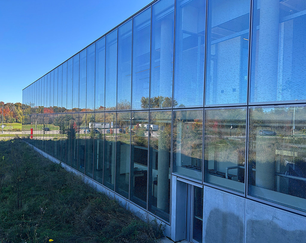
272. North of St. Peter’s is the campus of the University of Toronto Mississauga (UTM). It was founded as Erindale College in 1963, became the University of Toronto at Mississauga in 1998, and since 2007 has been known simply as UTM. It’s the largest academic division of the U of T outside its main downtown Toronto campus. Its Principal serves as the Vice-President of the whole of the U of T. UTM currently has a student population of 17,000, and is largely a commuter campus. When I visited on a Saturday in the Fall term, the student pub was closed and campus mainly deserted. There are, however, plans to greatly expand the current 2,000 residence places.
(Top) The 6.5 metre tall stone monument at the entrance on Mississauga Road, a kind of gigantic flattened inukshuk, cost $1M in 2013. That outlay was the cause of considerable controversy. Students, who dubbed the monument “The Stonehenge of Idiots” and “The Rock Bottom,” protested that the money might have been better spent on programs.
(Middle) The Athletics and Wellness Centre. Almost all the buildings in UTM were built recently, concrete and glass predominating.
(Bottom) The Science Building.

273. Most of Mississauga is boxed by freeways and the 427 ETR, which implies car-dependency. But actually the city has invested heavily and successfully in public transit. MiWay is the seventh largest bus provider in Canada, with almost 60 million annual passengers. It runs 55 local and 10 express routes, as well as a bus-only Transitway connecting Square One with Pearson Airport. This latter has greatly improved transit access to YYZ from the west, as buses no longer get stuck in traffic en route. Dundas Street in Mississauga is served by the MiWay #1 Local route and the #101 Express route, all the way from Winston Churchill Boulevard in the west to Kipling TTC subway station in the east.

274. Just before the Dundas Street West bridge over the Credit River, we enter Erindale Village. Erindale began as the Mississaugan village on the Credit, became Springfield-on-the-Credit in 1889, then was renamed Erindale in 1900, to honour James McGrath (see #271 above).


275. (Top) The Credit River looking south from the Dundas Street West bridge. The Credit, about 90 km long, arises near Orangeville and flows into Lake Ontario at Port Credit. Its name was Missinnihe (“trusting creek”) to the Mississaugas, who would receive goods for the winter – guns, knives, metal cooking pots and kettles, woollen blankets, liquor – on credit at the trading post at the river’s mouth in return for pelts of beaver, fox, muskrat, etc., to be trapped or hunted the following spring. So to the French fur traders it became known as La Rivière au Crédit.
(Bottom) In late October the chinook salmon are running. That’s why there are fishers on both sides of what is a very shallow Credit at this time of year.


276. Erindale Park, the largest in Mississauga, is on the east bank of the Credit north of Dundas Street West.
(Top) The Park as viewed from Dundas Street West.
(Middle) A footbridge across the Credit and that rural path connects the Park to the UTM campus.
(Bottom) The Park is very busy on this fine early fall weekend.


277. Three traces of Erindale Village on the south side of Dundas Street West, opposite Erindale Park. From west to east:
(Top) Erindale Community Hall (1928) at 1620 Dundas Street West.
(Middle) Erindale Academy at 1576 Dundas West, formerly Froebel School, is a Grades 7-12 university-preparation private school specializing in “Future-ready learning through AI Literacy, Hands-on Intelligence, and Social Intelligence.” The annual fee for 12-year-olds entering the “AI Business Innovation & Entrepreneurship Program” is $25,800.
(Bottom) Erindale Presbyterian Church (originally the Wesleyan-Methodist Church, 1877) at 1560 Dundas West. The spire is new, having been replaced in 2010. The land on which the church was built was donated by Emerson Taylor (see #278 below).

278. Emerson Taylor (1814-93), an immigrant from Pennsylvania, settled here in 1837. In the 1840s he bought a sawmill along the Credit River, and later he established a knitting mill, a hosiery factory, and a turning mill which made furniture and cases for grandfather clocks. In 1859 he bought the local inn and renamed it the Royal Exchange Hotel. It soon became one of the most important staging posts along this stretch of Dundas Street. (It burnt down in 1919.) From the 1860s Taylor, a Methodist, served as the local Justice of the Peace and Postmaster. As well as donating land to build the Methodist Church, he was behind the establishment of what is now the Cosmopolitan Cemetery, after a Methodist was refused burial in St. Peter’s Cemetery. In 1878 he built what’s now known as the Taylor-Froebel House at 1584 Dundas Street West; it still stands in the grounds of Erindale Academy.


279. We’ve left Erindale and are now in more urban Cooksville. Mississauga has a very diverse population, people of white European background accounting for only about a third of the city’s total population. South Asians are the largest minority group, and (top) food stores like this one at Clayhill Road reflect that demographic. That tall building poking up behind the supermarket …
(Bottom) … is M3, an 81-storey landmark that is now both the tallest building in Mississauga as well as the tallest Canadian tower outside Toronto. From the developer: “Launched in 2018, M3 was celebrated not only for its record height but also its striking design by Arcadis. Featuring a slender profile with a subtle twist at its base and crown, the tower culminates in a dramatic sloped peak that punctuates Mississauga’s evolving skyline … and reflects the character of Mississauga’s downtown.” Not quite sure what that last phrase is supposed to mean!
To view Mississauga’s cluster of often quirky residential skyscrapers up close, go to Burnhamthorpe Road, which runs parallel to Dundas Street 2.2 km to the north.
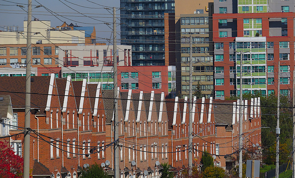
280. Dense residential developments line the north side of Dundas Street West as we approach central Mississauga.

281. Dundas Street West looking east from near the top of the hill where it intersects with Clayhill Road.

Map 26. This takes us from C, where Dundas Street West intersects with Hurontario Street (numbered 20 on the map), to D where Dundas Street East crosses Etobicoke Creek and, leaving Mississauga, enters the City of Toronto.

282. A sawmill was built in 1807 on Cooksville Creek, a couple of hundred metres east of where Dundas Street crosses Hurontario Street, the central north-south thoroughfare in Mississauga. One Jacob Cook settled here in 1819, and built a tavern, The Cooksville House, in 1829 on the northwest corner of the crossroads. The crossroads village was named for him in 1836. The first post office here was named “Toronto” in 1826 after the surrounding Township. Cooksville became the location for the Toronto Township Hall in 1874, and was an important stagecoach stop on the “Dundas Highway” in this area. This spot was potentially the site of Mississauga’s city centre, but lost out to the developers of Square One, 2 km to the north.

283. At its junction with Dundas Street, this is Hurontario Street looking north. The street’s name is a portmanteau of those of the two Great Lakes which it connected. It was formerly known as Centre Road in Toronto Township. It starts at Port Credit on the Ontario shore, and divides West from East in lateral road names, including Dundas Street’s. Today its original course is hard to follow after Hwy 10 ends near Shelburne. But there are back roads, some still called Centre Road, that will eventually take you to Collingwood on Georgian Bay (Lake Huron).
At the moment, the whole length of Hurontario Street through Mississauga is under construction. A Light Rail Transit (LRT) line is being built down the middle of it. It’s to be called the Hazel McCallion Line, honouring the longtime Mayor of Mississauga – she served for a scarcely believable 36 years from 1978-2014 – who died in 2023 at the age of 101. The line’ll be 18 km long, with 19 stations between Port Credit and Brampton. Brampton voted against the project for fear the line would destroy its historic centre, but in 2025 the Ontario Premier “solved” the problem by announcing that the line would be extended into Brampton via a tunnel. The total contract cost was then established at $5.6 billion. (Don’t hold your breath.)
The light rail vehicles (a.k.a. trams) that will serve the line are electrically driven and produce no emissions. The line is currently expected to open in 2031 and initially carry 32 million riders p.a. But then the line, begun in Spring 2020, was supposed to have opened long before now. For reasons too complex and tedious to go into here, LRT lines in southern Ontario are notoriously slow to construct and tend to be vastly overbudget when complete. There has of course been considerable disruption to businesses and traffic here in the Cooksville area, with no relief in sight.


284. We’re on the Dundas Street East bridge crossing the GO rail line between Toronto’s Union Station and Milton.
(Top) Looking west as the line heads toward Cooksville GO Station, the Mississauga skyline rises up, about 3 km away …
(Bottom) … while looking east in the direction of Dixie GO Station, the downtown Toronto skyline is just about visible. The CN Tower is 18.3 km away as the crow flies.

285. Here we’re at the crest of the rail bridge looking west along the canyon of Dundas Street East as it passes through central Mississauga.


286. Mississauga Chinese Centre is at 852 Dundas Street East, on the south side just east of Haines Road. It’s a 30,000 square metre mall in traditional Chinese style, built in 1988. There are more than 40 businesses on site including restaurants, a bank, arts and crafts centers, a ginseng shop, a supermarket, and other services.
(Top) The main gateway arch on Dundas Street is 13 metres tall, contains 17,000 cubic metres of timber, and was assembled without the use of a single nail.
(Bottom) A detail from the Nine Dragon Wall on the western side of the site. Such Walls traditionally served as screens at the garden gates of imperial Chinese palaces. The Wall here, in glazed brick like the original, is a replica of the Nine Dragon Wall (built 1402) in Beihai Park, Beijing.


287. (Top) We’re looking west, back where we came from. The Mississauga skyline is now about 7 km away. For the first time since Erindale, Dundas Street makes a curve. In so doing it’s conforming to the shoreline of Lake Ontario, which also curves at the point where Etobicoke Creek meets it …
(Bottom) … and as we turn to look east, that concrete rampart at left is the Dundas Street bridge over Etobicoke Creek. The Creek, from the Lakeshore to Eglinton Avenue,* serves as the boundary between the cities of Mississauga and Toronto.
*At Eglinton the boundary leaves the Creek and follows Hwy 427 north, so as to include Pearson Airport and the village of Malton in Mississauga’s embrace.

288. Etobicoke Creek looking north in early fall, after a long dry spell. That’s Mississauga on the left bank, Toronto on the right.
Part 11 coming soon.

